Standish, Michigan
| Standish, Michigan | |
|---|---|
| City | |
 Location of Standish within Arenac County, Michigan | |
| Coordinates: 43°58′59″N 83°57′32″W / 43.98306°N 83.95889°WCoordinates: 43°58′59″N 83°57′32″W / 43.98306°N 83.95889°W | |
| Country | United States |
| State | Michigan |
| County | Arenac |
| Incorporated | 1903 |
| Government | |
| • Type | Council-manager |
| • Mayor | Mark Winslow |
| • City Manager | Curt Hillman |
| Area[1] | |
| • Total | 2.15 sq mi (5.57 km2) |
| • Land | 2.15 sq mi (5.57 km2) |
| • Water | 0 sq mi (0 km2) |
| Elevation | 623 ft (190 m) |
| Population (2010)[2] | |
| • Total | 1,509 |
| • Estimate (2012[3]) | 1,472 |
| • Density | 701.9/sq mi (271.0/km2) |
| Time zone | Eastern (EST) (UTC-5) |
| • Summer (DST) | EDT (UTC-4) |
| ZIP code | 48658 |
| Area code(s) | 989 |
| FIPS code | 26-76120[4] |
| GNIS feature ID | 638715[5] |
Standish is a city in the U.S. state of Michigan. The population was 1,509 at the 2010 census. It is the county seat of Arenac County.[6]
History
The town was platted by John D. Standish in 1871. Before the plat was formally recorded, Standish sold some of his land in the community. The town was initially named "Granton." Standish owned the town's first business (a sawmill), and had the name changed back. Jackson and Lansing Railroad reached the community in 1871. It was incorporated as a village in 1893 and a city in 1903.[7]
Geography
According to the United States Census Bureau, the city has a total area of 2.15 square miles (5.57 km2), all land.[1]
Demographics
| Historical population | |||
|---|---|---|---|
| Census | Pop. | %± | |
| 1880 | 246 | — | |
| 1890 | 611 | 148.4% | |
| 1900 | 829 | 35.7% | |
| 1910 | 828 | −0.1% | |
| 1920 | 795 | −4.0% | |
| 1930 | 803 | 1.0% | |
| 1940 | 981 | 22.2% | |
| 1950 | 1,186 | 20.9% | |
| 1960 | 1,214 | 2.4% | |
| 1970 | 1,184 | −2.5% | |
| 1980 | 1,264 | 6.8% | |
| 1990 | 1,377 | 8.9% | |
| 2000 | 1,581 | 14.8% | |
| 2010 | 1,509 | −4.6% | |
| Est. 2015 | 1,452 | [8] | −3.8% |
2010 census
As of the census[2] of 2010, there were 1,509 people, 619 households, and 353 families residing in the city. The population density was 701.9 inhabitants per square mile (271.0/km2). There were 682 housing units at an average density of 317.2 per square mile (122.5/km2). The racial makeup of the city was 95.3% White, 0.5% African American, 1.5% Native American, 0.4% Asian, 0.7% from other races, and 1.6% from two or more races. Hispanic or Latino of any race were 2.6% of the population.
There were 619 households of which 30.2% had children under the age of 18 living with them, 36.7% were married couples living together, 14.7% had a female householder with no husband present, 5.7% had a male householder with no wife present, and 43.0% were non-families. 36.7% of all households were made up of individuals and 16.3% had someone living alone who was 65 years of age or older. The average household size was 2.27 and the average family size was 2.96.
The median age in the city was 40 years. 23.6% of residents were under the age of 18; 8.7% were between the ages of 18 and 24; 24.2% were from 25 to 44; 25.7% were from 45 to 64; and 17.8% were 65 years of age or older. The gender makeup of the city was 48.1% male and 51.9% female.
2000 census
As of the census[4] of 2000, there were 1,581 people, 619 households, and 362 families residing in the city. The population density was 738.1 per square mile (285.2/km²). There were 672 housing units at an average density of 313.7 per square mile (121.2/km²). The racial makeup of the city was 96.52% White, 0.25% African American, 0.63% Native American, 0.89% Asian, 0.82% from other races, and 0.89% from two or more races. Hispanic or Latino of any race were 2.02% of the population.
There were 619 households out of which 32.1% had children under the age of 18 living with them, 39.4% were married couples living together, 14.2% had a female householder with no husband present, and 41.4% were non-families. 37.5% of all households were made up of individuals and 20.2% had someone living alone who was 65 years of age or older. The average household size was 2.36 and the average family size was 3.08.
In the city the population was spread out with 26.2% under the age of 18, 9.2% from 18 to 24, 27.5% from 25 to 44, 19.0% from 45 to 64, and 18.2% who were 65 years of age or older. The median age was 37 years. For every 100 females there were 82.6 males. For every 100 females age 18 and over, there were 78.4 males.
The median income for a household in the city was $22,212, and the median income for a family was $31,719. Males had a median income of $28,523 versus $20,333 for females. The per capita income for the city was $13,608. About 16.4% of families and 19.1% of the population were below the poverty line, including 18.5% of those under age 18 and 14.7% of those age 65 or over.
Education
The city of Standish is in the Standish-Sterling Community Schools District. There are two elementary schools: Sterling Elementary located in Sterling and Standish Elementary School in Standish. Standish-Sterling Middle School operates in the former Standish-Sterling High School. A new high school, Standish-Sterling Central High School, opened in 2001.
Transportation
Major Highways
Bus
- Indian Trails provides daily intercity bus service between St. Ignace and Bay City, Michigan.[10]
Attractions
- The Saganing Eagles Landing Casino is located south of town in Whites Beach Area.
Correctional Facility
Standish is home to the state Standish Maximum Correctional Facility. In late 2009 the facility was considered, along with the U.S. Disciplinary Barracks in Fort Leavenworth, Kansas, as a potential United States site for more than 220 prisoners to be relocated from the Guantanamo Bay detention camp. Many neighbors of both sites expressed concern, with opposition expressed in Michigan[11][12] and Kansas.[13] In December 2009, the slated location of the detention camp was moved to Thomson, Illinois. As of 2016, however, no detention camp has been built and remaining detainees are still at Guantanamo, as Republicans in the Congress refused to authorize the relocation.
External links
- Standish Area Chamber of Commerce
- The History of Standish, transcribed from the Arenac County Independent, March 28, 1912
References
- 1 2 "US Gazetteer files 2010". United States Census Bureau. Retrieved 2012-11-25.
- 1 2 "American FactFinder". United States Census Bureau. Retrieved 2012-11-25.
- ↑ "Population Estimates". United States Census Bureau. Retrieved 2013-06-03.
- 1 2 "American FactFinder". United States Census Bureau. Retrieved 2008-01-31.
- ↑ U.S. Geological Survey Geographic Names Information System: Standish, Michigan
- ↑ "Find a County". National Association of Counties. Retrieved 2011-06-07.
- ↑ "City Of Standish". americantowns.com.
- ↑ "Annual Estimates of the Resident Population for Incorporated Places: April 1, 2010 to July 1, 2015". Retrieved July 2, 2016.
- ↑ "Census of Population and Housing". Census.gov. Retrieved June 4, 2015.
- ↑ "BAY CITY-ALPENA-CHEBOYGAN-ST. IGNACE" (PDF). Indian Trails. March 19, 2013. Retrieved 2013-04-03.
- ↑ Associated Press, "Michigan's Standish Maximum Correctional Facility wants prisoners from Guantanamo Bay"|work= New York Daily News |date=4 August 2009
- ↑ ABC News. "Local Pols Welcome Gitmo Prisoners, Residents Say 'Not So Fast'". ABC News.
- ↑ Kansas senators threaten action over moving Guantanamo detainees to Leavenworth |work= Lawrence Journal-World |date= 6 August 2009
Municipalities and communities of Arenac County, Michigan, United States | ||
|---|---|---|
| Cities | 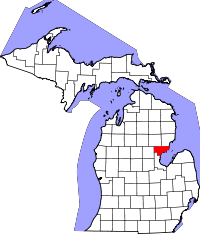 | |
| Villages | ||
| Townships | ||
| Unincorporated community | ||