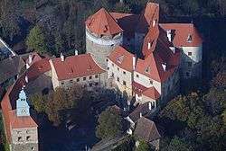
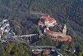
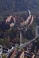
Stadtschlaining
| Stadtschlaining | ||
|---|---|---|
 | ||
| ||
 Stadtschlaining Location within Austria | ||
| Coordinates: 47°19′N 16°16′E / 47.317°N 16.267°ECoordinates: 47°19′N 16°16′E / 47.317°N 16.267°E | ||
| Country | Austria | |
| State | Burgenland | |
| District | Oberwart | |
| Government | ||
| • Mayor | Herbert Dienstl | |
| Area | ||
| • Total | 42.1 km2 (16.3 sq mi) | |
| Elevation | 409 m (1,342 ft) | |
| Population (1 January 2016)[1] | ||
| • Total | 2,004 | |
| • Density | 48/km2 (120/sq mi) | |
| Time zone | CET (UTC+1) | |
| • Summer (DST) | CEST (UTC+2) | |
| Postal code | 7461 | |
| Website | www.stadtschlaining.co.at | |

Stadtschlaining (Hungarian: Városszalónak, Város-Szalónak; Southern Bavarian: Stodschlaining) is a town in the district of Oberwart in the Austrian state of Burgenland. The European University Center for Peace Studies is in Stadtschlaining.
Population
| Historical population | ||
|---|---|---|
| Year | Pop. | ±% |
| 1869 | 3,586 | — |
| 1880 | 3,633 | +1.3% |
| 1890 | 3,675 | +1.2% |
| 1900 | 3,566 | −3.0% |
| 1910 | 3,121 | −12.5% |
| 1923 | 2,795 | −10.4% |
| 1934 | 2,695 | −3.6% |
| 1939 | 2,567 | −4.7% |
| 1951 | 2,424 | −5.6% |
| 1961 | 2,255 | −7.0% |
| 1971 | 2,273 | +0.8% |
| 1981 | 2,203 | −3.1% |
| 1991 | 2,284 | +3.7% |
| 2001 | 2,093 | −8.4% |
| 2011 | 2,064 | −1.4% |
References
Gallery
This article is issued from Wikipedia - version of the 9/28/2016. The text is available under the Creative Commons Attribution/Share Alike but additional terms may apply for the media files.