St Martin in the Fields (parish)
| St Martin in the Fields | |
|---|---|
| Civil parish | |
 | |
| Area | |
| • 1881/1921 | 286 acres (1.16 km2) |
| Population | |
| • 1881 | 17,508 |
| • 1901 | 12,980 |
| • 1921 | 10,666 |
| History | |
| • Origin | Ancient parish |
| • Abolished | 1922 |
| • Succeeded by | City of Westminster (parish) |
| Status | Civil parish |
| Government |
St Martin in the Fields Vestry |
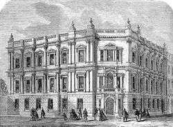
| • HQ | Vestry Hall, St Martin's Place |
| Contained within | |
| • Poor Law Union |
Strand (1868–1913) City of Westminster (1913–1922) |
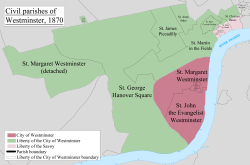
St Martin in the Fields was a civil parish in the metropolitan area of London, England. It took its name from the church of St Martin-in-the-Fields and was within the Liberty of Westminster. It included within its boundaries the former extra-parochial areas of Buckingham Palace and St. James's Palace.[1]
Adjustments
It was an ancient parish. In 1542 it gained the territory between the church of St Clement Danes and the Palace of Westminster from the parish of St Margaret.[2]
It originally included the following, which were carved out as new parishes:[3]
- St Paul Covent Garden (1645)
- Westminster St James (1685)
- St Anne Within the Liberty of Westminster (1687)
- St George Hanover Square (1724)
Poor law
It was a single parish for poor law following the Poor Law Amendment Act 1834 until 1868 when it became part of the Strand Poor Law Union.
Reform
In 1855 the parish vestry became a local authority within the area of responsibility of the Metropolitan Board of Works.
Under the Metropolis Management Act 1855 any parish that exceeded 2,000 ratepayers was to be divided into wards; as such the incorporated vestry of St Martin in the Fields was divided into three wards (electing vestrymen): No. 1 (12), No. 2 (12) and No. 3 (12).[4][5]
In 1896 as its population had increased the incorporated vestry was re-divided into three new wards (electing vestrymen): Park (15), Long Acre (12) and Embankment (9).[6]
In 1889 the parish became part of the County of London and in 1900 it became part of the Metropolitan Borough of Westminster. The St Martin in the Fields Vestry was replaced by Westminster City Council and the vestry hall became Westminster City Hall.
The civil parish was abolished in 1922.
References
- ↑
- Sir Walter Besant and Geraldine Edith Mitton (1903). The Strand District, The Fascination of London. Adam and Charles Black at Project Gutenberg
- ↑ http://www.british-history.ac.uk/report.aspx?compid=41023
- ↑ Youngs, Frederic (1979). Guide to the Local Administrative Units of England. I: Southern England. London: Royal Historical Society. ISBN 0-901050-67-9.
- ↑ The London Gazette Issue: 21802. 20 October 1855. pp. 3896–3898. Retrieved 9 April 2015.
- ↑ "H.M.S.O. Boundary Commission Report 1885 Westminster Map". Vision of Britain. Retrieved 9 April 2015.
- ↑ The London Gazette Issue: 26709. 14 February 1896. pp. 860–861. Retrieved 8 April 2015.
| Districts |
|  Headquarters at Spring Gardens |
|---|---|---|
| Incorporated vestries | Original vestries (1855)
Later vestries
| |
| Undertakings | ||
| Major works | ||
| Legislation | ||
| People | ||
History of the formation of the City of Westminster | ||
|---|---|---|
| Metropolitan boroughs |  | |
| District boards | ||
| Parishes | ||
| Liberties | ||