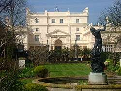
St John's Lodge, London

St. John's Lodge' is a private residence. Since 1994, it has been leased by the Kuwaiti royal family and the royal family of Brunei.[1] It was for a time the London home of Prince Jefri Bolkiah of Brunei.[2]
It is located on the Inner Circle of Regent's Park, London, which until 1965 was in the Metropolitan Borough of St Marylebone and is now part of the City of Westminster.[3]
It was built in 1812[4] and designed by the architect John Raffield, for Charles Augustus Tulk. The lodge was the first house to be built in Regents Park. The Royal Parks service describes it and The Holme as the only two villas remaining from John Nash's original conception of Regents Park.,[5] which would have included a royal palace, as well as many large villas; a scheme which was soon abandoned. Other owners of the lodge have included Lord Wellesley, Sir Isaac Goldsmid and a Marquess of Bute
The building was occupied by the University of London's Institute of Archaeology, from 1937 to 1959, and by the history and classics departments of Bedford College, from 1959 to 1983. The adjoining gardens have been open to the public since 1928.[6]
References
- ↑ http://www.londongardensonline.org.uk,
- ↑ Is the party over for runaway billionaire Prince Jefri of Brunei?". The Daily Telegraph. June 14, 2008.
- ↑ Westminster Boundary (Map). City of Westminster. 2008. LA 100019597 2008. Retrieved 2009-04-14.
- ↑ Regent's Park, from London Footprints
- ↑ The Regent's Park, Royal Park Service
- ↑ http://www.londongardensonline.org.uk
Bibliography
- Stourton, James (2012). Great Houses of London (Hardback). London: Frances Lincoln. ISBN 978-0-7112-3366-9.
Coordinates: 51°31′46″N 0°09′09″W / 51.52957°N 0.15250°W