St. Thomas Municipal Airport (Ontario)
| St. Thomas Municipal Airport | |||||||||||||||||||
|---|---|---|---|---|---|---|---|---|---|---|---|---|---|---|---|---|---|---|---|
| IATA: YQS – ICAO: CYQS | |||||||||||||||||||
| Summary | |||||||||||||||||||
| Airport type | Public | ||||||||||||||||||
| Operator | Municipality of St. Thomas | ||||||||||||||||||
| Location | St. Thomas, Ontario | ||||||||||||||||||
| Time zone | EST (UTC−05:00) | ||||||||||||||||||
| • Summer (DST) | EDT (UTC−04:00) | ||||||||||||||||||
| Elevation AMSL | 779 ft / 237 m | ||||||||||||||||||
| Coordinates | 42°46′12″N 081°06′35″W / 42.77000°N 81.10972°WCoordinates: 42°46′12″N 081°06′35″W / 42.77000°N 81.10972°W | ||||||||||||||||||
| Map | |||||||||||||||||||
 CYQS Location in Ontario | |||||||||||||||||||
| Runways | |||||||||||||||||||
| |||||||||||||||||||
| Statistics (2006) | |||||||||||||||||||
| |||||||||||||||||||
St. Thomas Municipal Airport, (IATA: YQS, ICAO: CYQS), located 3.5 nautical miles (6.5 km; 4.0 mi) east of St. Thomas, Ontario, Canada is a small airport serving the general aviation needs of the area. The airport was established in 1941 as an air training base for the British Commonwealth Air Training Program. The base was operated by the Department of National Defence until the late 1940s as a relief field for No. 14 Service Flying Training School Aylmer, Ontario and No. 4 Bombing & Gunnery School Fingal, Ontario. It has a six runways, and four IFR approaches.[3]

The airport is classified as an airport of entry by Nav Canada and is staffed by the Canada Border Services Agency (CBSA). CBSA officers at this airport can handle general aviation aircraft only, with no more than 15 passengers.[1]
The airport was purchased by the City of St. Thomas in 1970. The runways were built approximately 2,640 ft (805 m) long, but the main east west runway (09/27) was expanded to 5,050 ft (1,539 m) in 1982.
The airport is in uncontrolled airspace but has a UNICOM operating during working hours on 122.70 MHz.
There is one flight training school operating out of the airport, and many agricultural aircraft in the summer.
In 2002 St. Thomas reported 27,456 aircraft movements, however over the following years the numbers dropped. In 2003 there were 17,371, followed by 13,720 in 2004 and 12,575 in 2005. In 2006 there were 944 movements reported during a 24-day period in January and no more reports were made for the rest of the year.[4]
BCATP buildings from 1941
 Pumphouse
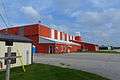 Hangar, Apron side
 Hangar, Furnace End
 Hangar, Doors
References
- 1 2 Canada Flight Supplement. Effective 0901Z 15 September 2016 to 0901Z 10 November 2016
- ↑ "Total aircraft movements by class of operation". Statcan.gc.ca. 2012-12-19. Retrieved 2013-10-02.
- ↑ McGrath, T.M. (1992). History of Canadian Airports (2nd ed.). Ottawa: Lugus Publications in co-operation with Transport Canada. ISBN 0-921633-11-4.
- ↑ Transport Canada TP 577 - Aircraft Movement Statistics Annual Report 2006 Archived August 9, 2007, at the Wayback Machine.
| By name | |
|---|---|
| By location indicator | |
| By province/territory | |
| By region | |
| National Airports System | |
| Related | |
| |