St. Pauli
| St. Pauli | |
|---|---|
| Quarter of Hamburg | |
|
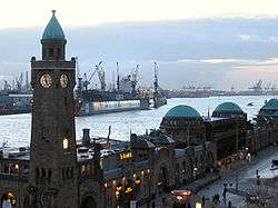
St. Pauli Piers and the port of Hamburg | |
 St. Pauli | |
| Coordinates: 53°33′25″N 9°57′50″E / 53.55694°N 9.96389°ECoordinates: 53°33′25″N 9°57′50″E / 53.55694°N 9.96389°E | |
| Country | Germany |
| State | Hamburg |
| City | Hamburg |
| Area | |
| • Total | 2.6 km2 (1.0 sq mi) |
| Population (31 December 2005) | |
| • Total | 27,612 |
| • Density | 11,000/km2 (28,000/sq mi) |
| Time zone | CET/CEST (UTC+1/+2) |
| Dialling codes | 040 |
| Vehicle registration | HH |
St. Pauli (Sankt Pauli; German pronunciation: [ˌzaŋkt ˈpaʊli]; Northern Low Saxon: Sünn Paul), located in the Hamburg-Mitte borough, is one of the 105 quarters of the city of Hamburg, Germany. Situated on the right bank of the Elbe river, the Landungsbrücken are a northern part of the port of Hamburg. St. Pauli contains a world-famous red light district around the street Reeperbahn. In 2006 the population was 27,612.
History
At the beginning of the 17th century it developed as a suburb called 'Hamburger Berg' (Hamburg mountain) outside the gates of the nearby city of Hamburg and close to the city of Altona. The name comes from a hill in that area that was planned by Hamburg in 1620 for defence reasons (free field of fire for the artillery). Therefore, settlement was initially allowed there, but soon businesses, which were desired inside neither Hamburg nor Altona, e.g. for their smell or noise, were relegated to 'Hamburger Berg'. Also the rope makers (or 'Reeper' in Low German) went here because in the city it was hard to find enough space for their work. The name of St. Pauli's most famous street Reeperbahn, or "Rope Walk," harkens back to its rope making past. When people were officially allowed to live in St. Pauli at the end of the 17th century the city government moved workhouses and (pestilence) hospitals out of the city to 'Hamburger Berg,' which later was named after its still existing church, 'St. Pauli' (Saint Paul). St. Pauli was mainly used by sailors for entertainment during their stay in Hamburg and Altona. To this day it is known as the sinful mile, combining the upper and common standards of entertainment, from musicals, theatres, to bars and clubs, as well as the most known red light district.
There have been various social issues and conflicts during the last decades, including the Hafenstraße, Rote Flora and Bambule.

Chinatown
Hamburg has very close ties to China and Asia in general. Since around 1890, it was home to the Chinesenviertel chinatown within its St. Pauli district (around Schmuckstrasse), which was disintegrated by the National Socialists in the 1930s. The St. Pauli chinatown is re-establishing since the 2010s. The city of Hamburg also hosts the biennial high-level conference Hamburg Summit: China meets Europe, has a major Chinese consulate at Elbchaussee 268 in Othmarschen since 1921, and has Shanghai as a sister city. A large contingent of Chinese and other Asian immigrants continue to live in the St. Pauli and Altona districts until today, while new arrivals gravitate to this part of the city.
Geography
It is situated directly on the north bank of the Elbe river close to the port of Hamburg. It is located south of Eimsbüttel, west of Hamburg-Neustadt and east of Altona. According to the statistical office of Hamburg and Schleswig-Holstein, the quarter has a total area of 2.6 km2 (1 sq mi).
Demographics
St. Pauli has 27,612 inhabitants in more than 17,000 households.[1] Immigrants were 27.9% of the population.[2] There were 11.9% with children under the age of 18 and 9.3% of the inhabitants were 65 years of age or older.[2] 63.4% of all households were made up of individuals.[1]

Education
The Bernhard Nocht Institute for Tropical Medicine (BNI) is located in the Bernhard Nocht Straße 7. It is a research center for tropical and infectious diseases and provides an information center about health risks, vaccinations and medical data about other countries for tourism and travel advice. The research facility formerly located in the Bernhard Nocht Straße hospital is now in the University Medical Center Hamburg-Eppendorf (UKE), Martinistraße 52. BNI website
In 2006 there were two elementary schools and a secondary school in St. Pauli.[3]
Culture and recreation

A prominent symbol is its football club, FC St. Pauli and the Millerntor-Stadion. The club played host to the inaugural FIFI Wild Cup in May–June 2006.
In 2010 the FC St. Pauli was one hundred years old. For the jubilee the Fan club 18auf12 recorded a song: One Hundred Beers (Words and music by Henning Knorr & Christoph Brüx).[4]
St. Pauli has a long tradition as a recreation and amusement centre. The big port of Hamburg led many sailors to Hamburg who preferred to spend their spare time (while their ships were unloaded and loaded again) in this area. Since then there has been prostitution in St. Pauli, and it is still best known as Hamburg's red-light district. The red-light district is an area of a few streets around the street Reeperbahn, often referred to as the Kiez.
Bars and music clubs have a tradition in the Kiez St. Pauli. The Beatles lived in St. Pauli and played at the Star-Club before becoming famous. They were honoured by the naming of Beatles-Platz square. Singer and actor Hans Albers is strongly associated with St. Pauli, providing the neighbourhood's unofficial anthem, with "Auf der Reeperbahn Nachts um Halb Eins" (On the Reeperbahn at Half Past Midnight) from the movie Große Freiheit Nr. 7. The square of Hans-Albers-Platz near Reeperbahn was named after him.
The district is referenced in the song "St Pauli" by Art Brut, which also contains the lyrics "Punk rock ist nicht tot" ("punk rock is not dead").
The Swedish post-industrial rock band Sällskapet's song Nordlicht talks about a pub in the area. The song contains detailed instructions supposedly leading to the location of the pub.
The Guardian counted St. Pauli to the five best places to live in the world.[5]
Voluntary associations
Important voluntary/cultural organisations in St. Pauli are:
- Parkhaus e.V. (an integrative living project) [6]
- Kunst- und Kulturverein (culture association) LINDA e.V. [7]
- Buddhistisches Zentrum Hamburg e.V.
- IG St. Pauli und Hafenmeile e.V.
- FC St. Pauli von 1910 e.V.
- CAFE mit Herz e.V. [8]
- Lions-Club Hamburg-St. Pauli
- JUGEND UND SPORT e.V. (Youth and Sport) (social pedagogy projects)[9]
- Viva con Agua de St. Pauli e.V..,[10] a charity-based organisation located in St. Pauli/Hamburg campaigning for clean drinking water worldwide

Infrastructure
The Federal Maritime and Hydrographic Agency Bundesamt für Seeschiffahrt und Hydrographie (BSH) is located in Bernhard Nocht Str. 78. The BSH is a federal authority coming under the jurisdiction of the Federal Ministry of Transport, Building and Urban Affairs. Among other things, it provides information of all matters of maritime shipping, to special funding programmes, law of flag, certification of mariners and informations of the coasts and coastal waters of Germany. Official website BSH
The head office of Federal Bureau for Maritime Casualty Investigation is in the BSH facility.[11][12]
Transportation

The rapid transit system serves St. Pauli with the city train stations Landungsbrücken and Reeperbahn and the underground railway stations Landungsbrücken, St. Pauli and Feldstrasse. Public transport is also provided by busses and ferries to the other bank of the Elbe river.
As of 2006, according to the Department of Motor Vehicles (Kraftfahrt-Bundesamt), 5487 private cars were registered in St. Pauli.[13]
Notes
- 1 2 residents registration office (1999) (Source: statistical office Nord of Hamburg and Schleswig-Holstein)
- 1 2 residents registration office (31 December 2005) (Source: statistical office Nord of Hamburg and Schleswig-Holstein)
- ↑ Source: statistical office Nord of Hamburg and Schleswig-Holstein (2006)
- ↑ One Hundred Beers website of the fan club 18auf12 14.11.2010
- ↑ http://www.guardian.co.uk/money/2012/jan/20/five-best-places-to-live-in-world?INTCMP=SRCH
- ↑ integrative living project 15.11.2010
- ↑ Website of the culture association LINDA e.V am 15.11.2010
- ↑ website of the IG St. Pauli, Voluntary associations 15.11.2010
- ↑ website of Jugend und Sport 15.11.2010
- ↑ viva con agua 15.11.2010
- ↑ "Imprint." Federal Bureau for Maritime Casualty Investigation. Retrieved on 16 January 2012. "Bundesstelle für Seeunfalluntersuchung (BSU) Bernhard-Nocht-Strasse 78 20359 Hamburg " - Map
- ↑ "Impressum." Federal Maritime and Hydrographic Agency of Germany. Retrieved on April 19, 2014. "Bundesamt für Seeschifffahrt und Hydrographie (BSH) Bernhard-Nocht-Straße 78 20359 Hamburg Postfach 30 12 20 20305 Hamburg"
- ↑ Source: statistical office Nord of Hamburg and Schleswig-Holstein
See also
- Reeperbahn, a street in the quarter St. Pauli (the so-called red-light district).
References
- Statistical office Hamburg and Schleswig-Holstein Statistisches Amt für Hamburg und Schleswig-Holstein, official website (German)
External links
| Wikimedia Commons has media related to St. Pauli. |
-
 Altona-St. Pauli travel guide from Wikivoyage
 - Hamburg's tourism pages
Freie und Hansestadt Hamburg | |
| Government and Symbols | |
| History and Culture | |
| Economy and Transport | |