Saint Joe River
| Saint Joe River | |
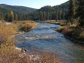 Saint Joe River in the St. Joe National Forest | |
| Country | United States |
|---|---|
| State | Idaho |
| Counties | Shoshone County, Benewah County, Kootenai County |
| Source | Northern Bitterroot Range |
| - location | southwest of Superior, Montana, Shoshone County, Idaho |
| - elevation | 6,487 ft (1,977 m) [1] |
| - coordinates | 47°01′07″N 115°04′58″W / 47.01861°N 115.08278°W [2] |
| Mouth | Coeur d'Alene Lake |
| - location | north of Heyburn State Park, Kootenai County, Idaho |
| - elevation | 2,129 ft (649 m) [2] |
| - coordinates | 47°23′35″N 116°45′15″W / 47.39306°N 116.75417°WCoordinates: 47°23′35″N 116°45′15″W / 47.39306°N 116.75417°W [2] |
| Length | 140 mi (225 km) [3] |
| Basin | 1,850 sq mi (4,791 km2) [4] |
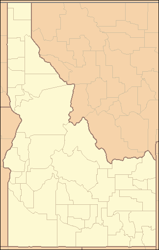 Location of the mouth of the Saint Joe River in Idaho | |
The Saint Joe River (sometimes abbreviated St. Joe River) is a 140-mile (225 km) long[3] tributary of Coeur d'Alene Lake in northern Idaho. Beginning at an elevation of 6,487 feet (1,977 m)[1] in the Northern Bitterroot Range of eastern Shoshone County, it flows generally west through the Saint Joe River Valley and the communities of Avery and Calder. Past Calder, it flows into Benewah County and through the town of St. Maries, where it receives its largest tributary, the Saint Maries River. It then turns northwest, passing through Heyburn State Park before reaching its mouth just north of the Kootenai County line.[5] Much of the river's route through Heyburn State Park is partially flooded due to raised water levels from Post Falls Dam on the Spokane River below Coeur d'Alene Lake.[6] With a mouth elevation of 2,129 feet (648.9 m),[2] it has been described as the highest navigable river in the world.[7][8][9]
In 1978, 66.3 miles (107 km) of the river were protected by the National Wild and Scenic Rivers System, with 26.6 miles (42.8 km) designated as wild and another 39.7 miles (63.9 km) designated as recreational.[10]
The Saint Joe River drains 1,850 square miles (4,791 km2) of the Idaho Panhandle.[4] It is part of the Spokane River watershed, which in turn is part of the Columbia River basin. About 68 percent is owned by the United States Forest Service (the St. Joe National Forest), 4 percent is owned by the Bureau of Land Management, 2 percent is owned by the State of Idaho, and the rest is privately owned.[6]
The Saint Joe River watershed is covered primarily by mixed coniferous forest, which includes species such as Douglas fir, true fir, larch, and pine. Alder is common in the riparian zones of high altitude river valleys, while cottonwood dominates the lower altitude riparian zones, much of which have been converted to agricultural land. Rush, sedge, and cattails are common in the river's floodplains, which are also used to grow wild rice.[6]
The river is home to many species of fish, including native westslope cutthroat trout, mountain whitefish, cedar sculpin and other cottids, shiners, and nonnative rainbow and brook trout, chinook and Kokanee Salmon. The upper Saint Joe River is also home to the last self-sustaining population of vulnerable bull trout in the Coeur d'Alene Lake watershed.[6]
See also
- List of rivers of Idaho
- List of longest streams of Idaho
- List of National Wild and Scenic Rivers
- Tributaries of the Columbia River
References
- 1 2 Source elevation derived from Google Earth search using GNIS source coordinates.
- 1 2 3 4 "Saint Joe River". Geographic Names Information System. United States Geological Survey. June 21, 1979. Retrieved July 18, 2013.
- 1 2 "National Hydrography Dataset". United States Geological Survey. Retrieved July 18, 2013.
- 1 2 "St. Joe and St. Maries Rivers Watershed Advisory Group". Idaho Department of Environmental Quality. Retrieved July 18, 2013.
- ↑ Idaho Road and Recreation Atlas (Map) (2nd ed.). 1:250,000. Benchmark Maps. 2010. pp. 32–34. ISBN 978-0-929591-06-3. OCLC 567571371.
- 1 2 3 4 "St. Joe River Subbasin Assessment and Total Maximum Daily Loads" (PDF). Idaho Department of Environmental Quality. July 2003. Retrieved July 18, 2013.
- ↑ "About the Area". United States Forest Service. Retrieved July 18, 2013.
- ↑ Gottberg, John (2009). Idaho. New York, New York: Fodor's Travel. p. 224. ISBN 9781400007417. OCLC 261939615.
- ↑ Boone, Mary (2004). Uniquely Idaho. Chicago, Illinois: Heinemann Library. p. 11. ISBN 9781403446466. OCLC 54407745.
- ↑ "St. Joe River, Idaho". National Wild and Scenic Rivers System. Retrieved July 18, 2013.
External links
- St. Joe River Country Documentary produced by Idaho Public Television