St. David's Island, Bermuda
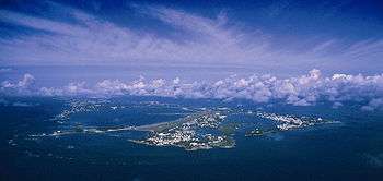
St. David's Island is one of the main islands of Bermuda. It is located in the far north of the territory, one of the two similarly sized islands that makeup the majority of St. George's Parish.
The island was originally 503 acres (2.04 square kilometres) in size, but was enlarged by reclamation, and by absorbing Long Bird Island and Cooper's Island, in 1942 to 650 acres (263.0 hectares) to allow room for a US military base (originally the US Army's Fort Bell/Kindley Field, later Kindley Air Force Base, and then USNAS Bermuda) which occupied over half the island. The base was closed in 1995, but much of its facilities are still used as part of L.F. Wade International Airport. Cooper's Island is now attached to the southeast St. David's, although the two islands are still widely regarded as if they were separate entities.
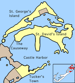
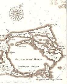
The island was named in honour of Saint David, the patron saint of Wales, as the similarly sized St. George's Island, to the north, had been named for the patron saint of England. The two islands are separated by two bodies of water - Ferry Reach in the south-west and St. George's Harbor in the north-east. St. David's is separated from the Bermudian mainland by the waters of Castle Harbor in the south, but is joined to it by road via The Causeway.
Notable features of the island include St. David's Head, Bermuda's easternmost point, and the nearby St. David's Battery, on Great Head (Great Head is the more prominent of two headland which comprise St. David's Head); L.F. Wade International Airport; St. David's Lighthouse; and Annie's Bay on Cooper's Island.
St. David's Island is connected to the United States by an Atlantic fiber Optic cable known as 360 Americas.
As with the rest of Bermuda, the St. David's islanders were established from a diverse group of immigrants, beginning in the 17th Century. These included indentured servants from England, Spanish-speaking Blacks from the West Indies, and Black, Native American, Irish, and Scottish slaves. The last three groups were largely composed of prisoners-of-war and others ethnically-cleansed from their homelands following English wars of conquest. Although hundreds of Native American slaves were absorbed into the population of all of Bermuda, other Bermudians have long distinguished St. David's islanders (disparagingly) as 'Mohawks'. Only two Mohawk boys were recorded as having been imported to Bermuda following Dutch-Mohawk wars, but to many English in the 17th Century, the Mohawks were the best known Native American people, and any Native American was likely to be described as a Mohawk. Today, many St. David's islanders are proud to be called Mohawks, and are actively re-establishing links to Wampanoag, Pequot and other Algonquian nations that contributed to Bermuda's settlement. Since the joining of the Island to the rest of Bermuda by the US Army in the 1940s, the former relative isolation of St. David's has ended. The subsequent influx of other Bermudians to what is seen as a more affordable part of Bermuda to buy property, which increased dramatically after the closure of NAS Bermuda in 1995, has eroded the unique character of the islands population, who were once distinguishable by accent and appearance.
Education
St. David's Preschool is on the island.[1]
St. David's Primary School is on the island.[2]
Clearwater Middle School is located on St. David's. It opened on September 6, 1997 in the former Roger B. Chaffee High School with 155 students originating from the former St. George's Secondary School.[3]
References
External links
- Bermuda Online
- Google Maps satellite photos of Bermunda
- Cape Cod Online: Worlds Rejoined.
- Genealogy.com: Massasoit
Coordinates: 32°22′03″N 64°40′47″W / 32.36750°N 64.67972°W