St. Clair-Superior
| St. Clair-Superior | |
|---|---|
| Neighborhoods of Cleveland | |
|
North Presbyterian Church, Superior Ave | |
| Country | United States |
| State | Ohio |
| County | Cuyahoga |
| City | Cleveland |
| Population (2010) | |
| • Total | 7,199 |
| 36.9% decrease from 2000 Census | |
| Demographics | |
| • White | 17.7% |
| • Black | 76% |
| • Hispanic | 5.6% |
| • Asian | >1% |
| • Other | 2.7% |
| Time zone | EST (UTC-5) |
| • Summer (DST) | EDT (UTC-4) |
| ZIP Codes | 44103 |
| Area code(s) | 216 |
| Median income | $18,636 |
| Source: 2010 U.S. Census, City Planning Commission of Cleveland[1] | |

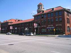

St. Clair-Superior is a near east side neighborhood of Cleveland, Ohio. St. Clair-Superior is one of the oldest and most culturally diverse neighborhoods in Cleveland, and is the location of Cleveland's original Chinatown neighborhood. Due to an influx of non-Chinese Asian Americans opening businesses in the area towards the latter decades of the 20th Century, city planners have since renamed the district Asiatown.[2] The district acts as a unifying factor for the Chinese, Taiwanese, Korean, Japanese, Filipino, Indian, Vietnamese, Cambodian, Laotian, Nepalese and Thai communities of Cleveland.[3] The neighborhood is bordered by Interstate 90 to the North, Payne Avenue to the South, and East 27th Street to the west. The eastern border is Rockefeller Park and its main street, Martin Luther King Jr. Drive.[4] The Catholic St. Martin de Porres High School and a branch of Horizon Science Academy (a charter school) are both located in St.Clair-Superior.
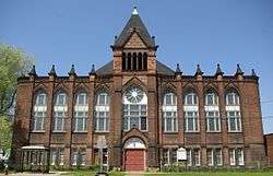
The historic St. Vitus's Church, at E.61st and Lausche Avenue, was the first Slovenian Catholic church built in Cleveland, and at one time was among the largest Slovenian congregations in the United States.[5]
References
- ↑ planning.city.cleveland.oh.us/2010census/downloads/2010SPA_Data.pdf
- ↑ http://ech.case.edu/cgi/article.pl?id=A21
- ↑ [http://www.unmiserable.com/cleveland/archive/?p=713
- ↑ Neighborhood Link: St. Clair - Superior. Accessed 2007-07-26.
- ↑ "Encyclopedia of Cleveland History:ST. VITUS CHURCH". Ech.cwru.edu. Retrieved 2012-11-08.
External links
Coordinates: 41°31′N 81°40′W / 41.517°N 81.667°W