Sri Ganganagar
| Sri Ganganagar Ramu Jat ki Dhani | |
|---|---|
| City | |
 Sri Ganganagar  Sri Ganganagar Location in Rajasthan, India | |
| Coordinates: 29°55′N 73°53′E / 29.92°N 73.88°ECoordinates: 29°55′N 73°53′E / 29.92°N 73.88°E | |
| Country |
|
| State | Rajasthan |
| District | Sri Ganganagar |
| Founded by | Maharaja Ganga Singh |
| Named for | Gang Canal |
| Government | |
| • Type | State Government |
| • Body | Government of India |
| Area | |
| • Total | 225 km2 (87 sq mi) |
| Elevation | 178 m (584 ft) |
| Population (2011) | |
| • Total | 254,760 |
| • Density | 1,100/km2 (2,900/sq mi) |
| Languages | |
| • Official | Hindi |
| • Regional | Rajasthani and Punjabi |
| Time zone | IST (UTC+5:30) |
| PIN | 335001 |
| Telephone code | 0154 |
| Vehicle registration | RJ 13 |
| Sex ratio | 873 ♂/♀ |
| Website | http://ganganagar.rajasthan.gov.in/ |
Sri Ganganagar (SGNR) is a planned city and the northern-most city of the Indian state of Rajasthan, situated near borders of Rajasthan and Punjab states and the international border of India and Pakistan. It is the administrative headquarters of Sri Ganganagar district. It is named after Maharaja Shri Ganga Singh Bahadur, Maharaja of Bikaner, it is also known as "the food basket of Rajasthan" and "Green district of Rajasthan".
History

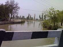
Sri Ganganagar was established by Maharaja Ganga Singh, near Ramnagar which was named after Ram Singh Ji Saharan and now known as 'Purani aabadi' and 'Ramu Jaat ki Dhaani'. Sri Ganganagar is one of the first well planned modern cities of India; it is said to be influenced by the town planning of Paris. It is divided into residential blocks and a commercial area which includes Dhan Mandi (Agricultural Crop Market Place). It is situated at the point where the Sutlej waters enter Rajasthan or the erstwhile Bikaner State. It is said by the elders that this area first came under the erstwhile Bahawalpur state but due to the large open area this was unguarded and Hindu Mal one of the companions of Maharaja Ganga Singh took advantage of this opportunity and changed the boundaries or the posts along the boundary. He started his journey to change posts from Suratgarh in south till Hindumalkot City in north of this district. He informed the Maharaja about his successful sneaky invasion of the area when he reached the northern part and thereafter died giving name to the city Hindumalkot.
In 1899-1900, the Bikaner State was affected by the worst famine. In order to resolve this issue permanently, Maharaja Ganga Singh obtained the services of AWE Standley, Chief Engineer, who demonstrated the feasibility of the western area of the Bikaner State being brought under irrigation from the Sutlej waters. The plan of the Sutlej Valley Project was drawn by then Chief Engineer of Punjab, RG Kennedy, according to which the vast area of erstwhile Bikaner State could be brought under irrigation. However, the project got delayed due to objections by the erstwhile State of Bahawalpur.
Finally, with intervention of then Viceroy of India, Lord Curzon, in 1906, a Tripartite Conference was held and an agreement was reached and signed on 4 September 1920. The foundation stone of the Canal Head Works at Ferozepur was laid on 5 December 1925 and the work completed in 1927 by constructing 143 km (89 mi) of lined canal. The opening ceremony was performed on 26 October 1927 by Lord Irwin, the then Viceroy of India. The plan for the city of Sri Ganganagar was drawn at this time. Irrigated parts of Bikaner State were brought under Sri Ganganagar district and later sub-divided into Hanumangarh district.
Location and area
Sri Ganganagar District is located between Latitude 28.4 to 30.6 and Longitude 72.2 to 75.3[1] The total area of Sri Ganganagar is 11,154.66 km² or 1,115,466 hectares. It is surrounded on the east by Hanumangarh District, (Hanumangarh district was carved out of it on 12 July 1994) on the south by Bikaner District, and on the west by Bahawalnagar district of the Pakistani Punjab and on the north by the Punjab.
Political Representation
Member of Parliament Ganganagar (Lok Sabha constituency) - Nihalchand, Bhartiya Janata Party
Member of Legislative Assembly (Rajasthan) - Kamini Jindal, National Unionist Zamindara Party
Topography
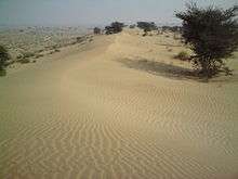
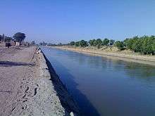
Although Ganganagar District lies in the great Thar desert, irrigation via the Gang canal and Indira Gandhi Nehar Priyojna has changed the flora and fauna. The district can be classified into five geographical regions:
- The region irrigated by the Gang canal and the Bhakhra canal tributaries: the northern region, which is 3/4 of the district, resembles the fertile plains of Punjab, but some areas, like the area between the towns of Raisinghnagar and Vijaynagar, have desert like conditions.
- Area irrigated by the Suratgarh branch of the IGNP canal
- Area irrigated by Anupgarh branch of IGNP canal: it comprises Anupgarh and Gharsana tehsils. It is the southernmost region of the district, of which much has been converted into plains, but sandy dunes can still be seen.
- The Naali belt: this is a narrow basin of the Ghaggar river. It is the only major river of the district. It is a seasonal river, which flows in the rainy season. It enters the district near Suratgarh and then flows in areas of Jaitsar, Vijaynagar, Anoopgarh and then crosses the Indo-Pakistan border.
- The 'Uncha Tibba' (high sandy dunes) area of Suratgarh tehsil: large sandy dunes and lack of water predominate here. This area can be said to be a 'real desert'. People of this area face harsh conditions in the desert.
Climate
The climate of Sri Ganganagar varies to extreme limits. Summer temperature reaches 50° Celsius and winter temperature dips just around 0° Celsius.[2] The average annual rainfall is only 200 mm (7.9 in).[3] Average maximum temperature in summer is 41.2 °C and average minimum temperature in winter is 6 °C.
| Climate data for Sri Ganganagar | |||||||||||||
|---|---|---|---|---|---|---|---|---|---|---|---|---|---|
| Month | Jan | Feb | Mar | Apr | May | Jun | Jul | Aug | Sep | Oct | Nov | Dec | Year |
| Record high °C (°F) | 36.1 (97) |
35.0 (95) |
41.6 (106.9) |
47.0 (116.6) |
50.0 (122) |
50.0 (122) |
46.8 (116.2) |
43.4 (110.1) |
43.8 (110.8) |
41.1 (106) |
39.0 (102.2) |
31.5 (88.7) |
50 (122) |
| Average high °C (°F) | 20.9 (69.6) |
23.5 (74.3) |
28.9 (84) |
36.5 (97.7) |
41.0 (105.8) |
41.5 (106.7) |
38.0 (100.4) |
37.1 (98.8) |
36.8 (98.2) |
34.9 (94.8) |
29.4 (84.9) |
23.1 (73.6) |
32.63 (90.73) |
| Average low °C (°F) | 5.8 (42.4) |
8.1 (46.6) |
13.0 (55.4) |
18.9 (66) |
24.3 (75.7) |
27.8 (82) |
27.5 (81.5) |
26.7 (80.1) |
23.9 (75) |
17.3 (63.1) |
11.2 (52.2) |
6.7 (44.1) |
17.6 (63.68) |
| Record low °C (°F) | −2.2 (28) |
−2.8 (27) |
0.6 (33.1) |
6.9 (44.4) |
11.7 (53.1) |
15.8 (60.4) |
14.5 (58.1) |
16.2 (61.2) |
14.0 (57.2) |
6.7 (44.1) |
1.7 (35.1) |
−1.7 (28.9) |
−2.8 (27) |
| Average precipitation mm (inches) | 10.3 (0.406) |
13.6 (0.535) |
8.2 (0.323) |
14.8 (0.583) |
14.6 (0.575) |
36.2 (1.425) |
99.2 (3.906) |
71.5 (2.815) |
38.2 (1.504) |
2.4 (0.094) |
3.6 (0.142) |
3.9 (0.154) |
316.5 (12.462) |
| Source: IMD (extreme high and lows up to 2010) | |||||||||||||
Demographics
According to the 2011 census Sri Ganganagar district has a population of 1,969,520,[5] roughly equal to the nation of Slovenia[6] or the US state of New Mexico.[7] This gives it a ranking of 235th in India (out of a total of 640).[5] The district has a population density of 179 inhabitants per square kilometre (460/sq mi) .[5] Its population growth rate over the decade 2001-2011 was 10.06%.[5] Ganganagar has a sex ratio of 873 females for every 1000 males,.[5][5] Males constitute 52.99% of the population and females 47.01%. Ganganagar has an average literacy rate of 70.25%, higher than the national average of 59.8%: male literacy is 79.33%, and female literacy is 60.07%. In Ganganagar, 13% of the population is under 6 years of age. Majority of the population is Hindu, Jain and Sikh.
Economy
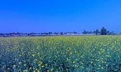
Desert land was converted to a green town by the efforts of Maharaja Ganga Singh, who brought the Gang canal. which carries the excess waters of Punjab and Himachal Pradesh to the region, making Ganganagar district known as "the food basket of Rajasthan".[8] The economy of the city is based on agriculture, its main crops are wheat, mustard and cotton. Other crops are guar, bajra, sugar cane and grams. In recent years, farmers are also diverting towards horticulture. Kinnow (a citrus family fruit or a hybrid citrus fruit from "orange") is a popular horticultural product; other fruits of the citrus family are also grown.
Industries in Sri Ganganagar District are based on agriculture. Major industries are cotton ginning and pressing factories, mustard oil mills, wheat flour mills, Rajasthan State Ganganagar Sugar Mills, which is known for its Royal Heritage Liqueurs.[9][10] 20 top renowned industries are Vikas WSP (P)Limited, T.C. Fresh Kinnow Waxing, Kanda Edible Oil Unit, Ruchi Soya Indusjtries etc. It also has cotton spinning and textile factories such as JCT Mills (now closed). Most of the factories are located in and around Sri Ganganagar City.
Education
Sri Ganganagar has many education institutes including Tantia University, Nosegay Public School.
Notable personalities
- Jagjit Singh: Famous Ghazal singer, was born in Sri Ganganagar.
- Col Avtar Singh Cheema (1933–1989): An Arjuna Awardee who was the first Indian to climb Mount Everest.
- Shahid Mallya: Bollywood singer.
- Ravinder Kaushik: Former Research and Analysis Wing agent.
Culture
Majority of people in the district speak Bagri. Punjabi, too is popular. A number of writers of the district have made contributions to Rajasthani literature, through Bagri.[11]
Bagri culture dominates the district, while Punjabi culture also has certain influence in some areas.
The embroidered Odhni (mostly red in colour) is a symbol of Bagri women. A long shirt and ghaghro (long frock type clothes) and borlo (a head ornament) is the traditional dress of Bagri women.
The Purdah (or veil) is mainly in vogue among Bagri women. Men mainly wear a pant-shirt, kurta-payjama and dhoti.
Traditional Hindi music and Rajasthani devotional music is popular. Bollywood songs are listened to with same enthusiasm as in other northern Indian regions.
Religion
Majorly followed religion here is Hinduism followed by Sikhism due to its vicinity with Punjab. Major gods and goddesses of Hinduism have their shrines here. Apart from it, locals also worship some regional gods such as Baba Ramdev ji, Bhomiya ji and Goga ji. Several sects of Sikhism such as Dera Sachha Sauda, Radha Soami, Nirankari etc. are revered here in good faith and numbers. Islam and Christianity also has their presence here with few Mosques and Churches in place. Migrants from other states are major followers of minority religions.
Tourist attractions

Tourist attractions include
- Historical Gurudwara Buddha Johad. A large gurudwara, which is 55 km from Ganganagar in the south-west. This is a place where Bhai Sukha Singh and Mehtab Singh brought the head of Massa Rangarh (guilty of sacrilege of the Amritsar Golden Temple) and hung it on a tree on 11 August 1740.
- Bror Village. The ruins of the Indus valley civilisation are found here. It is located on Anoopgarh-Ramsinghpur road.
- Dada Pamparam's Dera is at Vijayanagar town, and is the samadhi (tomb) of Baba Pamparam.
- Laila-Majnu ki Mazar (tomb), Binjaur village.Laila Majnu Ki Mazar is 11 km (6.6 mi) far from Anoopgarh on the western side. Here is the so-called mazar of Laila-Majnu, actually this was built in remembrance of mutual devotion and love between a teacher and a student. A fair is held in June.
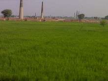
%2CAnupgarh_Sivender.jpg) Laila-Majnun ki Mazar near Anupgarh city
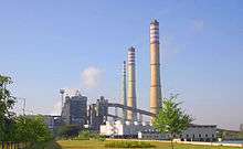
Laila-Majnun ki Mazar near Anupgarh city - The Suratgarh Super Critical Thermal Power Station is an electricity production project that is maintained by the Rajasthan Rajya Vidhyut Utpadan Nigam Limited. It is Rajasthan’s foremost super thermal power station. This station has been successful in controlling pollution and maintaining balance of atmospheric emissions in the environment. The Union Ministry of Power has awarded this power station with the Golden Shield Award. Village 3C Chhoti 12 km north-west from district headquarters. This village is first planned village in India. This village is designed by architect Le Corbusier with the help of Bhagh singh sandhu and mayer singh sekhon.
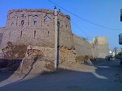
- Anoopgarh Fort is a ruin in the city of Anoopgarh. It was built by Anoop Singh Rathore.
- Suratgarh-Jaitsar state agriculture farm.
- The Hindumalkot Border, the Indo-Pak Border, derives its name from Hindumal, the Diwan of Bikaner. Pakistan’s Observation Post can be seen from this site.
- H.H. Gardens,[12] now known as Surendera Group of Institutions,[12] surendera dental college[13] is famous for best BDS, MDS, M.Tech, B.Tech, MBA diploma GNM courses[14] in Rajasthan & northern India.

Temples and places for worship


The landscape of Sri Ganganagar is dotted with numerous temples and religious places. The famous temples in Sri Ganganagar include
- Gayatri shaktipeeth dedicated to maa gayatri the goddess of vedas the temple is located at g-1-a hanuman nagar
- Ram Mandir
- The Gauri Shankar Temple is dedicated to Lord Shiva. There is a Shivalinga in the sanctum of this temple. This temple is built using sandstone and has two cone shaped turrets.,
- Siddhi Jhaanki Wale Hanumaan Ji Ka Mandir,
- Hanumaan Mandir dedicated to Hanuman located in the heart of the city, in L-Block.
- Balaji Dhaam is situated on Hanumangarh Road, near the Ridhi Sidhi Enclave. This temple is devoted to Sri Balaji and is surrounded by numerous other temples,
- Durga Mandir dedicated to goddess Durga, surrounded by a crowded market, the area in the evening is crowded by youth.
- Rojhri Dham is a complex of religious sites dedicated to the worship of the Hindu deity Hanuman. Dham attracts many local worshippers throughout the year. On Chaitra Purnima and Ashvin Purnima every year, large jagrans are organized, where thousands of people assemble to pay their homage to the deity. Hanuman Sewa Samiti manages the Temple and Jagarans. The temple of Hanuman is situated on right side of Anupgarh-Bikaner road, about one kilometre from Rojhri Village.
- Chanana-Dham(Chanana shrine)A great temple of Lord Hanumanji is here, built in 1971. It is 36 km from district headquarters on the way to Padampur (Tehsil) on bifurcating road at Chunawad town along with GG canal.
In addition to this, religious centres such as Gurudwara Shri Budha Johar Shaheb and Shivpuri Kagad are common tourist destinations. Shri Jagadamba Andh-vidhyalaya, one of the largest institutes of India for the education of visually, hearing and speech impaired people is also a place worth visiting. It is situated within Sri Ganganagar city.
Tehsils and other towns
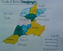
Ganganagar tehsils
There are following nine tehsils in Ganganagar district.
Other major towns and villages
Kesrisinghpur, Gajsinghpur, Suratgarh, Ramsinghpur, Jaitsar, Rawla Mandi are major towns, whereas Lalgarh Jatan, Ridmalsar, Kikarwalee, Budhajor, Binjhbayla, Rajiasar, Patroda, Sameja Kothi, Chunawadh, Birmana, Hindumalkot, Zorawar singh pur, Banda colony, Bajuwala, Birmana Khat, Sajwar, Mirjawala, Netewala are small towns and villages.
Many towns and cities in Sri Ganganagar District are named after members of the royal family of the former Bikaner State.
References
- ↑ http://ganganagar.nic.in/
- ↑ "Temperature Regimes". Water Resource Department - Government Of Rajasthan. Retrieved 2008-12-06.
- ↑ INDIA METEOROLOGICAL DEPT
- ↑ http://www.census2011.co.in/census/city/64-ganganagar.html
- 1 2 3 4 5 6 "District Census 2011". Census2011.co.in. 2011. Retrieved 2011-09-30.
- ↑ US Directorate of Intelligence. "Country Comparison: Population". Retrieved 2011-10-01.
Slovenia 2,000,092 July 2011 est.
- ↑ "2010 Resident Population Data". U. S. Census Bureau. Retrieved 2011-09-30.
New Mexico - 2,059,179
- ↑ Garg, Balwant (2003-07-27). "Suicide woes fill the 'food basket'". The Times of India. Retrieved 2008-12-06.
- ↑ http://www.royalheritageliqueur.com/
- ↑ http://www.rsgsm.net/default.asp
- ↑ M. Paul Lewis, ed. (2009). "Bagri: A language of India". Ethnologue: Languages of the World (16th ed.). Dallas, Texas: SIL International. Retrieved 2011-09-28.
- 1 2 "Home". Surendera Group of Institutions. Retrieved 2015-11-18.
- ↑ "Welcome - Surendera Dental College". SDC & RI. Retrieved 2015-11-18.
- ↑ "Welcome - Surendera Dental College". SNC. Retrieved 2015-11-18.
External links
| Outline | 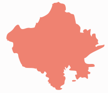 | ||||||||||||||||||||||||||
|---|---|---|---|---|---|---|---|---|---|---|---|---|---|---|---|---|---|---|---|---|---|---|---|---|---|---|---|
| Governance | |||||||||||||||||||||||||||
| Divisions and Districts |
| ||||||||||||||||||||||||||
| Major cities | |||||||||||||||||||||||||||
| Related templates |
| ||||||||||||||||||||||||||