Squares of Savannah, Georgia
The city of Savannah, Georgia, United States, was laid out in 1733 around four open squares, each surrounded by four residential ("tything") blocks and four civic ("trust") blocks. Once the four wards were developed in the mid-1730s, two additional wards were laid out. The layout of a square and eight surrounding blocks was known as a "ward." The original plan (now known as the Oglethorpe Plan) was part of a larger regional plan that included gardens, farms, and "out-lying villages." While some authorities believe that the original plan allowed for growth of the city and thus expansion of the grid, the regional plan suggests otherwise: the ratio of town lots to country lots was in balance and growth of the urban grid would have destroyed that balance.[1]
Oglethorpe's agrarian balance was abandoned after the Georgia Trustee period. Additional squares were added during the late-18th and 19th centuries, and by 1851 there were 24 squares in the city (The names of all but the two "lost" squares in Savannah are: Franklin, Ellis, Johnson, Reynolds, Warren, Washington, Liberty, Green, Telfair, Wright, Oglethorpe, Colombia, Green, Elbert, Orleans, Chippewe, Craford, Pulaski, Madison, Lafayette, Troup, Chatham, Monteroy, Calhound, and Whitefield.) In the 20th century, three of the squares were demolished or altered beyond recognition, leaving 21. In 2010, one of the three "lost" squares, Ellis, was reclaimed. Most of Savannah's squares are named in honor or in memory of a person, persons or historical event, and many contain monuments, markers, memorials, statues, plaques, and other tributes.
Overview

The city of Savannah was founded in 1733 by General James Oglethorpe. Although cherished by many today for their aesthetic beauty, the first squares were originally intended to provide colonists space for practical reasons such as militia training exercises.[2][3][4] The original plan resembles the layout of contemporary military camps, which were likely quite familiar to General Oglethorpe. The layout was also a reaction against the cramped conditions that fueled the Great Fire of London in 1666, and there is speculation that Oglethorpe's military studies had made him familiar with the similar layout of Beijing (or "Peking," as it was formerly spelled).[5] A square was established for each ward of the new city. The first four were Johnson, Percival (now Wright), Ellis, and St. James (now Telfair) Squares, and themselves formed a larger square on the bluff overlooking the Savannah River. The original plan actually called for six squares, and as the city grew the grid of wards and squares was extended so that 33 squares were eventually created on a five-by-two-hundred grid. (Two points on this grid were occupied by Colonial Park Cemetery, established in 1750, and four others—in the southern corners of the downtown area—were never developed with squares.) When the city began to expand south of Gaston Street, the grid of squares was abandoned and Forsyth Park was allowed to serve as a single, centralized park for that area.[6]
All of the squares measure approximately 200 feet (61 m) from east to west, but they vary north to south from approximately 100 to 300 feet (91 m). Typically, each square is intersected north-south and east-west by wide, two-way streets. They are bounded to the west and east by the south- and north-bound lanes of the intersecting north-south street, and to the north and south by smaller one-way streets running east-to-west and west-to-east, respectively. As a result, traffic flows one way—counterclockwise—around the squares, which thus function much like traffic circles.[7]
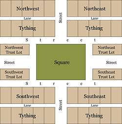
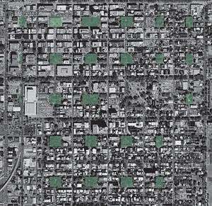
Each square sits (or, in some cases, sat) at the center of a ward, which often shares its name with its square. The lots to the east and west of the squares, flanking the major east-west axis, were considered "trust lots" in the original city plan and intended for large public buildings such as churches, schools, or markets. The remainder of the ward was divided into four areas, called tythings, each of which was further divided into ten residential lots.[5] This arrangement is illustrated in the 1770 Plan of Savannah, reproduced here, and remains readily visible in the modern aerial photograph above. The distinction between trust lot and residential lot has always been fluid. Some grand homes, such as the well-known Mercer House, stand on trust lots, while many of the residential lots have long hosted commercial properties.
All of the squares are a part of Savannah's historic district and fall within an area of less than one half square mile.[8] The five squares along Bull Street—Monterey, Madison, Chippewa, Wright, and Johnson—were intended to be grand monument spaces and have been called Savannah's "Crown Jewels." Many of the other squares were designed more simply as commons or parks, although most serve as memorials as well.[3]
Architect John Massengale has called Savannah's city plan "the most intelligent grid in America, perhaps the world", and Edmund Bacon wrote that "it remains as one of the finest diagrams for city organization and growth in existence." The American Society of Civil Engineers has honored Oglethorpe's plan for Savannah as a National Historic Civil Engineering Landmark, and in 1994 the plan was nominated for inclusion in the UNESCO World Heritage List. The squares are a major point of interest for millions of tourists visiting Savannah each year, and they have been credited with stabilizing once-deteriorating neighborhoods and revitalizing Savannah's downtown commercial district.[7]
First four squares, 1733
The first four squares were laid out by James Oglethorpe in 1733, the same year in which he founded the Georgia colony and the city of Savannah.
Johnson Square
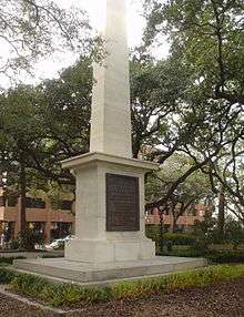

Johnson Square was the first of Savannah's squares and remains the largest of the 24. It was named for Robert Johnson, colonial governor of South Carolina and a friend of General Oglethorpe.[9][10] Interred in the square is Revolutionary War hero General Nathanael Greene, the namesake of nearby Greene Square. Greene died in 1786 and was buried in Savannah's Colonial Park Cemetery. His son, George Washington Greene, was buried beside him after drowning in the Savannah River in 1793. Following vandalism of the cemetery by occupying Union forces during the Civil War the location of Greene's burial was lost. After the remains were re-identified Greene and his son were moved to Johnson Square. An obelisk in the center of the square now serves as a memorial to Gen. Greene. The cornerstone of the monument was laid by the marquis de La Fayette in 1825. At that time the obelisk did not yet commemorate any specific individual or event. In fact, due to financial restrictions the unmarked obelisk served for several years as a joint monument to both Greene and Casimir Pulaski. Inscriptions honoring Greene were added in 1886, but the Greenes’ physical remains did not arrive until 1901, following their "rediscovery."[5][10][11]
Johnson Square contains two fountains, as well as a sundial dedicated to Colonel William Bull, the namesake of Savannah's Bull Street. Bull was a South Carolinian who assisted Oglethorpe with the establishment of Savannah and, as a surveyor, laid out the original street grid. The sundial has four panels, one on each side of its square granite base. The dial itself is bronze, set atop a marble shaft. One of the base panels reproduces a 1734 map of Savannah.[10]
Another landmark of Johnson Square includes the Johnson Square Business Center. This building, formerly known as the Savannah Bank Building, was the city's first "skyscraper", built in 1911. Johnson square is known as the financial district, or banking square, and many of the City's financial services companies are located here.[12] These companies include the Savannah Bancorp, Savannah Bank, Coastal Bank Headquarters, Bank of America branch, SunTrust branch, TitleMax Corporate Headquarters, and a Regions Bank building.
Johnson Square is located on Bull, between Bryan and Congress Streets.
Wright Square
The second square established in Savannah, Percival Square was named for Lord Percival, generally regarded as the man who gave the colony of Georgia its name (a tribute to Great Britain's King George II). It was renamed in 1763 to honor James Wright, the third, last and perhaps most notable of Georgia's royal governors. Throughout its history it has also been known as Court House Square and Post Office Square; the present Tomochichi Federal Building and U.S. Courthouse is adjacent to the west.[13]
The square is the burial site of Tomochichi, a leader of the Creek nation of Native Americans. Tomochichi was a trusted friend of James Oglethorpe and assisted him in the founding of his colony. When Tomochichi died in 1739 Oglethorpe ordered him buried with military honors in the center of Percival Square. In accordance with his people's customs the grave was marked by a pyramid of stones gathered from the surrounding area. In 1883, citizens wishing to honor William Washington Gordon replaced Tomochichi's monument with an elaborate and highly allegorical monument to Gordon.[10] William Gordon is thus the only native Savannahian honored with a monument in one of the city's squares.[13] Gordon's own widow objected strongly to this perceived insult to Tomochichi. She and other members of the Colonial Dames of the State of Georgia planned to erect a new monument to Tomochichi, made of granite from Stone Mountain. The Stone Mountain Monument Company offered the material at no cost. Mrs. Gordon felt that she was being condescended to and insisted on paying. The Monument Company sent her a bill—some sources say for 50 cents, others for one dollar—payable on Judgment Day. Mrs. Gordon paid the bill and attached a note explaining that on Judgment Day she would be occupied with her own affairs.[14] The new monument was erected in 1899. It stands in the southeast corner of the square and eulogizes Tomochichi as a great friend of James Oglethorpe and the people of Georgia.[5][10]
Wright Square is on Bull, between State and York Streets.
Ellis Square
Ellis Square is located on Barnard between Bryan and Congress Streets. The square was laid out in 1733 as part of Decker Ward, the third ward created in Savannah. The square was originally called Decker Square, named after Sir Matthew Decker, one of Trustees for the Establishment of the Colony of Georgia in America, Commissioner of funds collection for the Trust, director and governor of the East India Company, and member of Parliament. The square was renamed after Sir Henry Ellis, the second Royal Governor of the colony of Georgia.
It was also known as Marketplace Square, as from the 1730s through the 1950s it served as a center of commerce and was home to four successive market houses. Prior to Union General Sherman's arrival in December 1864, it was also the site of a slave market [3] with some indications of slave being held under the northwest corner of the square. A large brick building was built in the 1850s to house the market, facing south on Barnard St. In 1954 the city signed a 50-year lease with the Savannah Merchants Cooperative Parking Association, allowing the association to raze the existing structure and construct a parking garage to serve the City Market retail project. Anger over the demolition of the market house helped spur the historic preservation movement in Savannah.[7] The outer structure of this city market building influenced the design of the Kroger grocery store on Gwinnett St and the Publix grocery store in the Twelve Oaks shopping center on Abercorn Street.
When the garage's lease expired in 2004, the city began plans to restore Ellis Square. The old parking garage was demolished in 2006 to make way for a new public square (park) that features open spaces for public concerts, as well as an underground parking garage. The underground facility was completed and formally dedicated in January 2009. Meanwhile, hotel, residentialegun in the spring of 2008, was completed in February 2010. Ellis Square officially reopened at a dedication ceremony held on March 11, 2010.[15] A bronze statue, by Susie Chisholm, of songwriter-lyricist Johnny Mercer, a native Savannahian, was formally unveiled in Ellis Square on November 18, 2009.
Telfair Square
St. James Square was named in honor of a green space in London, England and marked one of the most fashionable neighborhoods in early Savannah.[13] It was renamed in 1883 to honor the Telfair family.[9] It is the only square honoring a family rather than an individual. The Telfairs included former Governor Edward Telfair, Congressman Thomas Telfair (Edward Telfair's son), and Mary Telfair (1791–1875), benefactor of Savannah's Telfair Museum of Art. The square also contains tributes to the Girl Scouts of the USA, founded by Savannahian Juliette Gordon Low, and to the chambered nautilus.[5] Telfair Square is located on Barnard, between State and York Streets.
Two new squares
Oglethorpe's plan called for six wards and squares. Lower New Square and Upper New Square—now Reynolds and Oglethorpe Squares—completed the founder's vision.
Reynolds Square
Lower New Square was laid out in 1734 and was later renamed for Capt. John Reynolds, governor of Georgia in the mid-1750s. Reynolds was in fact an unpopular governor and it is said that the celebration held upon his arrival in the colony was rivaled only by that held upon his departure.[13] The square contains a bronze statue by Marshall Daugherty honoring John Wesley, founder of Methodism. Wesley spent most of his life in England but undertook a mission to Savannah (1735–1738), during which time he founded the first Sunday school in America. The statue was installed in 1969 on the spot where Wesley's home is believed to have stood.[10][16] The statue is intended to show Wesley preaching out-of-doors as he did when leading services for Native Americans, a practice which angered church elders who believed that the Gospel should only be preached inside the church building.[3]
Reynolds Square was the site of the Filature, which housed silkworms as part of an early—and unsuccessful—attempt to establish a silk industry in the Georgia colony.[5][9] It is located on Abercorn, between Bryan and Congress Streets.
Oglethorpe Square
Upper New Square was laid out in 1742 and was later renamed in honor of Georgia founder General James Oglethorpe. The modest home of Georgia's first Royal Governor, John Reynolds, was located on the southeast Trust Lot (now a parking lot of The Presidents' Quarters Inn) overlooking Oglethorpe Square. Reynolds arrived in Savannah October 29, 1754. The residences of the Royal Surveyors of Georgia and South Carolina were located on the northeast Trust Lots, the site of today's Owens-Thomas House. The Presidents' Quarters Inn, a 16-room historic bed and breakfast, is located on the southeast Trust Lots. The square contains a pedestal honoring Moravian missionaries who arrived at the same time as John Wesley and settled in Savannah from 1735 to 1740, before resettling in Pennsylvania.[10][13][17] A Savannah veterans’ group had unsuccessfully proposed erecting a memorial to veterans of World War II in Oglethorpe Square.[5] (which was installed on River Street). Oglethorpe Square is located on Abercorn, between State and York Streets; President Street intersects east and west. After the American Revolutionary War, the British name of "Prince Street" was official renamed "State Street". "King Street" was renamed "President Street".
The 1790s
Savannah grew rapidly in the late 18th century and six new wards were established in the 1790s alone, including the four that now comprise the northeastern quadrant of the Historic District. The new wards expanded the grid by one unit to the west and by two to the east. Due to space restrictions these new wards are slightly narrower east-to-west than the original six.[13]
Washington Square
Built in 1790, Washington Square was named in 1791 for the first President of the United States, who visited Savannah in that year.[18] Washington Square had been the site of the Trustees' Garden.[9] Named for the trustees of Oglethorpe's colony, the garden was the testing ground for a variety of experimental crops – including mulberry (for silkworms), hemp, and indigo – viewed as potential cash crops. Most of these experiments proved unsuccessful.
Washington Square is on Houston, between Bryan and Congress Streets. It was one of only two squares named to honor a then-living person; Troup Square was the other. Washington Square was once the site of massive New Year's Eve bonfires; these were discontinued in the 1950s.[19]
Franklin Square
Franklin Square was designed and laid out in 1790. It is located on the western end of town at the intersection of Montgomery Street and W Julian Street, bordered on the north side by W Bryan St and on the south side by W Congress St.[20] It was named in 1791 for Benjamin Franklin who served as an agent for the colony of Georgia from 1768 to 1778 and who had died in 1790.[21]
The square held a forty foot tall water tower to distribute water to residents. It was built with after the previous system of public and private surface wells was overwhelmed by the rising population of the city. The water was taken out of the Savannah River west of the Ogelthorpe Canal Basin before being filtered and pumped up to the water tower.[22] Because of this the tower, Franklin Square was also known as Water Tank Square, Water Tower Square and Reservoir Square.[20]
The square was destroyed in 1935 with the routing of US Highway 17 on Montgomery Street but was restored in the mid 1980s.[20][23] The square now anchors the western end of the City Market retail area.[24] A memorial honoring Haitian volunteers who fought with Pulaski during the Siege of Savannah, created by sculptor James Mastin, was unveiled in Franklin Square on the 228th anniversary of the battle.[24]
Warren Square
Warren Square was laid out in 1791 and named for General Joseph Warren, a Revolutionary War hero killed at the Battle of Bunker Hill and who had served as President of the Provincial Government of Massachusetts.[5][6][18] British gunpowder seized by Savannahians had been sent to aid the Americans at Bunker Hill. The ‘’sister city’’ relationship between Savannah and Boston survived even the Civil War, and Bostonians sent shiploads of provisions to Savannah shortly after the city surrendered to General Sherman in 1864.[13] Warren Square is on Habersham, between Bryan and Congress Streets.
Columbia Square
Columbia Square was laid out in 1799 and is named for Columbia, the poetic personification of the United States. It is located on Habersham, between State and York Streets. In the center of the square is a fountain that formerly stood at Wormsloe, the estate of Noble Jones, one of Georgia's first settlers. It was moved to Columbia Square in 1970 to honor Augusta and Wymberly DeRenne, descendants of Jones. It is sometimes called the "rustic fountain," as it is decorated with vines, leaves, flowers, and other woodland motifs.[5][10]
Greene Square
Greene Square was laid out in 1799 and is named for Revolutionary War hero General Nathanael Greene, an aide to George Washington.[18] A native of Rhode Island, Greene commanded southern forces during the Revolution, and after the war settled at Mulberry Grove, an estate fourteen miles (21 km) above Savannah. Greene, along with his son, is actually buried in Savannah's Johnson Square. Greene Square was once the center of Savannah's African-American community.[5] On the northeast Trust Lot is Second African Baptist Church, the site where Union General William Sherman famously announced Special Field Orders 15, better known as "40 acres and a mule". Green Palm Inn (two seamen's cottages, ca. 1897) is on the square. The square is located on Houston, between State and York Streets. Before the American Revolutionary War, State Street was named Prince Street.
Liberty Square
Liberty Square was laid out in 1799 and named in honor of the Sons of Liberty and the victory over the British in the Revolutionary War. It was located on Montgomery between State and York Streets. It was paved over to make way for improvements to Montgomery Street. A small portion remains and is the site of the "Flame of Freedom" sculpture.[5]
19th-century squares
Expansion of Oglethorpe's grid of wards and squares continued through the first half of the 19th century, until a total of 24 squares stood in downtown Savannah.
Elbert Square
Elbert Square was laid out in 1801 and named for Samuel Elbert, a Revolutionary soldier, sheriff of Chatham County, and Governor of Georgia.[13] It was located on Montgomery between Hull and Perry streets. It was paved over to make way for improvements to Montgomery Street and today is represented by a small grassy area across Montgomery from the west entrance to the Civic Center.[5]
Chippewa Square

Chippewa Square was laid out in 1815 and named in honor of American soldiers killed in the Battle of Chippawa during the War of 1812. (The spelling "Chippewa" is correct in reference to this square.)
In the center of the square is as bronze statue of Georgia founder General James Oglethorpe created by sculptor Daniel Chester French and unveiled in 1910.[5] Oglethorpe faces south, toward Georgia's one-time enemy in Spanish Florida, and his sword is drawn.[17] Busts of Confederate figures Francis Stebbins Bartow and Lafayette McLaws were moved from Chippewa Square to Forsyth Park to make room for the Oglethorpe monument.[10] Due to the location of the monument, Savannahians sometimes refer to this as Oglethorpe Square, although the actual Oglethorpe Square sits just to the northeast.[13]
The "park bench" scene which opens the 1994 film Forrest Gump was filmed on the north side of Chippewa Square.[9] The bench was a fiberglass prop, rather than one of the park's actual benches.[5] A prop bench used in the film is on display at the Savannah Visitors Center. Chippewa Square is located on Bull, between Hull and Perry Streets.
Chippewa Square is also home to First Baptist Church (1833),[25] the Philbrick-Eastman House (1844),[26] and The Savannah Theatre (1818).
Orleans Square
Orleans Square was laid out in 1815, commemorating General Andrew Jackson's victory at the Battle of New Orleans in January of that year. In the center of the square the German Memorial Fountain honors early German immigrants to Savannah.[5] Installed in 1989 it commemorates the 250th anniversary of Georgia and of Savannah, as well as the 300th anniversary of the arrival in Philadelphia of 13 Rhenish families.[10] Orleans Square is located on Barnard, between Hull and Perry Streets, and is adjacent to the Savannah Civic Center.
Lafayette Square
Lafayette Square was laid out in 1837 and is named for Gilbert du Motier, marquis de La Fayette, the French hero of the American Revolution, who visited Savannah in 1825. The square contains a fountain commemorating the 250th anniversary of the founding of the Georgia colony, donated by the Colonial Dames of Georgia in 1984, as well as cobblestone sidewalks.[3][9][10] Lafayette Square is located on Abercorn, between Harris and Charlton Streets. Adjacent to the square is the Roman Catholic Cathedral of St. John the Baptist. Given this proximity Lafayette Square features prominently in Savannah's massive St. Patrick's Day celebrations. Water in the fountain is dyed green for the occasion.[13] In this area is the museum known as the Flannery O'Connor Childhood Home, which is open to the public.
Pulaski Square
Pulaski Square was laid out in 1837 and is named for General Casimir Pulaski, a Polish-born Revolutionary War hero who died of wounds received in the Siege of Savannah (1779).[18] It is one of the few squares without a monument—General Pulaski's statue is actually in nearby Monterey Square.[9] Prior to the birth of the historical preservation movement and the restoration of much of Savannah's downtown Pulaski sheltered a sizeable homeless population and was one of several squares that had been paved to allow traffic to drive straight through its center.[13]
Pulaski square is located on Barnard, between Harris and Charlton Streets and is known for its live oaks.
Madison Square
Madison Square was laid out in 1837 and named for James Madison, fourth President of the United States. In the center of the square is an 1888 statue by Alexander Doyle memorializing Sgt. William Jasper, a soldier in the Siege of Savannah who, though mortally wounded, heroically recovered his company's banner.[10] Savannahians sometimes refer to this as Jasper Square, in honor of Jasper's statue.[13] Madison Square features vintage cannon from the Savannah Armory.[9] These now mark the starting points of the first highways in Georgia, the Ogeechee Road leading to Darien and the Augusta Road to Augusta.[10][17] The square also includes a monument marking the center of the British resistance during the Siege.[3] Madison Square is located on Bull, between Harris and Charlton Streets.
Crawford Square
Crawford Square was laid out in 1841 and named in honor of Secretary of the Treasury William Harris Crawford, born in Amherst County Virginia in 1772.[18] Crawford ran for President in 1824 but came in third, after winner John Quincy Adams and runner-up Andrew Jackson.[6] Although Crawford is the smallest of the squares it anchors the largest ward, as Crawford Ward includes the territory of Colonial Park Cemetery.[5] It is located on Houston, between Hull and Perry Streets on the eastern edge of the historic district.[27] During the era of Jim Crow this was the only square in which African-Americans were permitted.[5] The square contains playground facilities, a basketball court, and a gazebo.[9] While all squares were once fenced it is the only one that remains so. Crawford Square has also retained its cistern, a holdover from early fire fighting practices.[5] After a major fire in 1820 firemen maintained duty stations in the squares, each of which was equipped with a storage cistern.[13]
Chatham Square
Chatham Square was laid out in 1847 and named in 1851 for William Pitt, 1st Earl of Chatham. Although Pitt never visited Savannah he was an early supporter of the Georgia colony and both Chatham Square and Chatham County are named in his honor. The square is located on Barnard, between Taylor and Gordon Streets. Chatham Square is sometimes known locally as Barnard Square, in reference to a city school that stood adjacent for many years.[13]
Monterey Square
Monterey Square was laid out in 1847 and commemorates the Battle of Monterrey (1846), in which American forces under General Zachary Taylor captured the city of Monterrey during the Mexican-American War. (The correct spelling in reference to the square is "Monterey", with a single r.) In the center of the square is an 1853 monument honoring General Casimir Pulaski. The cornerstone of the monument was laid by Lafayette—in Chippewa Square in 1825. Due to financial limitations an obelisk in Johnson Square served as a joint memorial to Nathanael Green and Pulaski for several years. By 1852 funds had been collected to give Pulaski his own monument. The sculptor was allowed to choose the site for the project and he had the cornerstone moved to Monterey Square.[10] Deterioration of the Pulaski monument was noted as early as 1912, and pieces began to fall in the 1990s. Restoration of the monument was completed in 2001. The body of an unknown Revolutionary soldier is said to be buried beneath Pulaski's monument, speculated by some to be Pulaski himself.[3][10]
Monterey Square is the site of Mercer House, built by Hugh Mercer and more recently the home of antiques dealer and restorationist Jim Williams. The house, and the square itself, were featured prominently in John Berendt's 1994 true crime novel Midnight in the Garden of Good and Evil. The square has been used as a setting for several motion pictures, including the 1997 film version of Berendt's novel.
The square also is home to Congregation Mickve Israel, which boasts one of the few Gothic-style synagogues in America, dating from 1878.
Monterey Square is located on Bull, between Taylor and Gordon Streets, and is widely considered to be the most picturesque of Savannah's squares. All of the surrounding buildings but one (the United Way Building) are original to the square.[19]
Troup Square
Troup Square was laid out in 1851 and named for former Georgia Governor, Congressman, and Senator, George Troup. It is one of only two squares named for a person living at the time (the other being Washington Square).[16] A large iron armillary sphere stands in the center of the square, supported by six small metal turtles.[10] The armillary has been the source of some controversy, as it is one of the few examples of modern sculpture in the squares.[13] Troup Square is located on Habersham, between Harris and Charlton Streets. A special dog fountain is located on the west side of the square. The Myers Drinking Fountain was a gift from Savannah mayor Herman Myers in 1897 and originally placed in Forsyth Park. When moved to Troup Square its height was adjusted for canine use and has become the site of an annual Blessing of the Animals.[5][10]
Calhoun Square
Calhoun Square was laid out in 1851 and is named for South Carolina statesman John C. Calhoun, who served as Secretary of War, Secretary of State, and as Vice President under John Quincy Adams and Andrew Jackson.[9] It is sometimes called Massie Square in reference to a neighborhood school.[13] It is the only square with all of its original buildings intact.[17] It is located on Abercorn, between Taylor and Gordon Streets.
Whitefield Square
Whitefield Square was laid out in 1851—the final square built. It is named for the Rev. George Whitefield, founder of Bethesda Home for Boys (a residential education program – formerly the Bethesda Orphanage) in the 18th century, and still in existence on the south side of the city. It has a gazebo in its center. A notable building facing the square is the First Congregational Church. Other prominent though 20th-century buildings are the Rose-of-Sharon Apartments and the Red Cross Building. It is on Habersham, between Taylor and Gordon Streets.
Forsyth Park
After 1851, as the city expanded south of Gaston Street, further extensions of Oglethorpe's grid of wards and squares were abandoned. Forsyth Park, located just south of Monterey Ward, was intended to be a single large park that would serve the growing southern portion of the city just as the squares had served their individual wards. The original northern portion of the park, surrounding the well-known fountain, occupied an area the size of an entire ward from the old city, and the park more than doubled in size during later years. Other, smaller neighborhood parks have been established in the southern portions of the city.
New squares
A huge section of land to the east of Broad Street is currently (May 2009) being developed along the lines of the grid plan of the Historic District, and is expected to contain several new squares.
Summary
| #[28] | Name | Name Origin | Year Established | Intersection | Monuments | Landmarks | Status |
|---|---|---|---|---|---|---|---|
| 1. | Franklin | Benjamin Franklin | 1790 | Montgomery Street and West St. Julian Street |
Chasseurs volontaires de Saint-Domingue[29] | First African Baptist Church | Nearly lost in the 1970s; restored |
| 2. | Ellis | Henry Ellis, Governor of Georgia |
1733 | Barnard Street and West St. Julian Street |
Johnny Mercer, songwriter, lyricist (sculpture by Susie Chisholm) |
City Market |
Lost in the 1950s; fully restored in 2010 |
| 3. | Johnson | Robert Johnson, Governor of South Carolina |
1733 | Bull Street and St. Julian Street |
Nathanael Greene, Major General |
Christ Church (Episcopal) | Preserved |
| 4. | Reynolds | John Reynolds, Governor of Georgia |
1734 | Abercorn Street and East St. Julian Street |
John Wesley, early leader of the Methodist movement |
Pink House Lucas Theater |
Preserved |
| 5. | Warren | Dr. Joseph Warren, Major General |
1791 | Habersham Street and East St. Julian Street |
John David Mongin House Spencer House |
Preserved | |
| 6. | Washington | George Washington, U.S. President |
1790 | Houston Street and East St. Julian Street |
Seaman's House | Preserved | |
| 7. | Liberty | Sons of Liberty | 1799 | 133 Montgomery Street | Flame of Freedom | County Courthouse | Lost |
| 8. | Telfair | Edward Telfair, Governor of Georgia[30] |
1733 | Barnard Street and West President Street |
Telfair Academy of Arts & Sciences Trinity Methodist Church |
Preserved | |
| 9. | Wright | James Wright, Governor of Georgia[31] |
1733 | Bull Street and President Street |
William Washington Gordon, Founder of the Central of Georgia Railway, Mayor of Savannah[32] Tomochichi, Creek Indian leader |
Lutheran Church of the Ascension Tomochichi Federal Building and U.S. Courthouse Old County Courthouse |
Preserved |
| 10. | Oglethorpe | James Oglethorpe, Founder of Savannah |
1742 | Abercorn Street and East President Street |
Owens-Thomas House, The Presidents' Quarters Inn, Moravian Monument |
Preserved | |
| 11. | Columbia | Columbia, American symbol |
1799 | Habersham Street and East President Street |
Wormsloe Fountain | Davenport House Kehoe House |
Preserved |
| 12. | Greene | Nathanael Greene, Major General |
1799 | Houston Street and East President Street |
Second African Baptist Church | Preserved | |
| 13. | Elbert | Samuel Elbert, Governor of Georgia |
1801 | 237 Montgomery Street | Savannah Civic Center | Lost | |
| 14. | Orleans | Battle of New Orleans | 1815 | Barnard Street and West McDonough Street |
German Societies Fountain | Champion-McAlpin House Savannah Civic Center |
Preserved |
| 15. | Chippewa | Battle of Chippawa | 1815 | Bull Street and McDonough Street |
James Oglethorpe, Founder of Savannah |
First Baptist Church Savannah Theatre |
Preserved |
| 16. | Crawford | William H. Crawford, U.S. Senator |
1841 | Houston Street and East McDonough Street |
Gazebo[33] | Preserved | |
| 17. | Pulaski | Casimir Pulaski, Brigadier General |
1837 | Barnard Street and West Macon Street |
Francis Bartow House | Preserved | |
| 18. | Madison | James Madison, U.S. President |
1837 | Bull Street and Macon Street |
William Jasper, Sergeant |
Green-Meldrim House St. John's Episcopal Church Scottish Rite Temple Old Savannah Volunteer Guards Armory Sorrel Weed House |
Preserved |
| 19. | Lafayette | Marquis de La Fayette, Lieutenant General |
1837 | Abercorn Street and East Macon Street |
Semiquincentenary Fountain | Cathedral of Saint John the Baptist Hamilton-Turner House Andrew Low House |
Preserved |
| 20. | Troup | George Troup, Governor of Georgia |
1851 | Habersham Street and East Macon Street |
Armillary sphere | McDonough Row Houses Kennedy Row Universalist Church |
Preserved |
| 21. | Chatham | William Pitt, 1st Earl of Chatham, U.K. Prime Minister |
1847 | Barnard Street and West Wayne Street |
Gordon Row | Preserved | |
| 22. | Monterey | Battle of Monterey | 1847 | Bull Street and Wayne Street |
Kazimierz Pułaski, Brigadier General |
Temple Mickve Israel Mercer House |
Preserved |
| 23. | Calhoun | John C. Calhoun, U.S. Senator and U.S. Vice President |
1851 | Abercorn Street and East Wayne Street |
Wesley Monumental Methodist Church Massie School |
Preserved | |
| 24. | Whitefield | George Whitefield, early leader of the Great Awakening |
1851 | Habersham Street and East Wayne Street |
Gazebo | First Congregational Church | Preserved |
See also
References
- City of Savannah's Savannah's Squares page, accessed June 13, 2007. This page contains links to individual pages on each of Savannah's 24 squares, many with photographs. These pages are referenced throughout this article.
- ↑ Wilson, Thomas D. The Oglethorpe Plan: Enlightenment Design in Savannah and Beyond. Charlottesville, VA: University of Virginia Press, 2012. Chapter 4.
- ↑ Roadside Georgia's Historic Squares of Savannah, accessed June 13, 2007
- 1 2 3 4 5 6 7 See Savannah by T.D. Conner (2001), accessed June 14, 2007
- ↑ Wilson, Thomas D. The Oglethorpe Plan: Enlightenment Design in Savannah and Beyond. Charlottesville, VA: University of Virginia Press, 2012. pp. 85-89
- 1 2 3 4 5 6 7 8 9 10 11 12 13 14 15 16 17 18 19 Tour Guide Manual for licensed tour guides in the City of Savannah, accessed June 16, 2007.
- 1 2 3 The Savannah Experience, Historic Savannah Squares, accessed June 16, 2007
- 1 2 3 Project for Public Spaces' Squares of Savannah, accessed June 13, 2007
- ↑ Savannah Metropolitan Planning District's map of the Historic District, accessed June 16, 2007
- 1 2 3 4 5 6 7 8 9 10 Savannah Scene magazine, May–June 2007, pp 10–11, accessed June 16, 2007.
- 1 2 3 4 5 6 7 8 9 10 11 12 13 14 15 16 17 City of Savannah's monuments page This page links directly to numerous short entries, many accompanied by photographs, discussing a variety of monuments, memorials, etc., in the squares and elsewhere. Accessed June 16, 2007.
- ↑ Mulberry Grove Plantation, accessed June 16, 2007.
- ↑
- 1 2 3 4 5 6 7 8 9 10 11 12 13 14 15 16 Chan Sieg (1984). The squares: an introduction to Savannah. Virginia Beach: Donning.
- ↑ An Introduction to Historic Savannah by John Duncan, February 23, 2004, accessed June 14, 2007.
- ↑ Savannah Morning News, March 3, 2010, from http://savannahnow.com/share/blog-post/lesley-conn/2010-03-03/ellis-square-grand-opening-schedule
- 1 2 Official Savannah Guide's Tour Savannah's Squares, accessed June 16, 2007.
- 1 2 3 4 Our Coast's guide to Savannah's Squares, accessed June 16, 2007. Site features an excellent interactive map of Savannah's squares and numerous photographs.
- 1 2 3 4 5 SavannahBest.com's ‘’Squares of Savannah’‘, accessed June 16, 2007
- 1 2 City of Savannah's Savannah's Squares page, accessed June 13, 2007.
- 1 2 3 "Franklin Square". Visit-Historic-Savannah.com. Visit-Historic-Savannah.com. Retrieved 21 February 2016.
- ↑ "Virtual Historic Savannah Project: Franklin Ward". Virtual Historic Savannah Project. Savannah College of Art and Design. Retrieved 21 February 2016.
- ↑ Fraser, Walter (2005). Savannah in the Old South. University of Georgia Press. p. 295. ISBN 082032776X. Retrieved 21 February 2016.
- ↑ "Squares of Savannah" (PDF). CityWalkingGuide.com. CityWalkingGuide.com. Retrieved 21 February 2016.
- 1 2 "Franklin Square - Savannah, GA". Savannah.com. Savannah.com. Retrieved 21 February 2016.
- ↑ Barry Sheehy; Cindy Wallace (1 February 2011). Savannah, Immortal City. Greenleaf Book Group. pp. 216–. ISBN 978-1-934572-70-2. Retrieved 17 August 2013.
- ↑ Whip Morrison Triplett (2006). Savannah. Arcadia Publishing. pp. 38–. ISBN 978-0-7385-4209-6. Retrieved 17 August 2013.
- ↑ Coastal Travel Guide's ‘’Savannah Squares’‘, accessed June 16, 2007.
- ↑ The squares of Savannah are not actually numbered. In this specific case, the squares are put in order primarily from the westernmost to the easternmost and also from the northernmost to the southernmost.
- ↑ The Chasseurs volontaires de Saint-Domingue monument is a tribute to the Haitian-American soldiers who helped the American troops during the Siege of Savannah in 1779. Four of the planned six figures were installed on October 8, 2007.
- ↑ Telfair Square was originally called St. James Square. The name was changed in 1883.
- ↑ Wright Square was originally called Percival Square. The name was changed in 1763.
- ↑ Another monument honors Native American Leader Tomochichi on the southeast side of the square. It was offered by the Colonial Dames in Georgia.
- ↑ Crawford Square has a playground and also is the only fenced square in Old Savannah's Historical District.
External links
- Downtown Savannah street map from Mapquest
- 32°04′30″N 81°05′23″W / 32.074938°N 81.089787°W Map and aerial views of the historic district from Visitor information from Savannah.com, accessed June 16, 2007.
- A street map of the historic district from Savannah.com, accessed June 14, 2007.
- Another street map of the historic district from Sherpa Guides, accessed June 16, 2007
- Savannah Squares book site, the popular tour book "Savannah Squares", accessed July 22, 2008.
- Haitian American Historical Society, organizers of the Haitian Volunteers monument, accessed June 16, 2007.
- A photo assay of all 24 squares in Savannah.