Springfield, Tennessee
| Springfield, Tennessee | |
|---|---|
| City | |
|
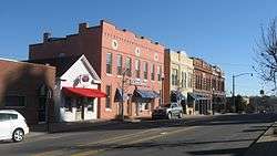
Fifth Avenue in Springfield | |
 Location of Springfield, Tennessee | |
| Coordinates: 36°29′58″N 86°52′43″W / 36.49944°N 86.87861°WCoordinates: 36°29′58″N 86°52′43″W / 36.49944°N 86.87861°W | |
| Country | United States |
| State | Tennessee |
| County | Robertson |
| Government | |
| • Type | Council/Manager |
| • Mayor | Billy-Paul Carneal |
| • City Manager | Paul Nutting |
| • Vice Mayor | Ann Scneider |
| Area | |
| • Total | 12.2 sq mi (31.6 km2) |
| • Land | 12.2 sq mi (31.6 km2) |
| • Water | 0.0 sq mi (0.0 km2) |
| Elevation | 660 ft (203 m) |
| Population (2013)Estimate | |
| • Total | 16,659 |
| • Density | 1,173.9/sq mi (453.3/km2) |
| Time zone | Central (CST) (UTC-6) |
| • Summer (DST) | CDT (UTC-5) |
| ZIP code | 37172 |
| Area code(s) | 615 |
| FIPS code | 47-70500[1] |
| GNIS feature ID | 1271139[2] |
| Website | http://www.springfield-tn.org |
Springfield is a city in and the county seat[3] of Robertson County, Tennessee. The population was 16,478 at the 2010 census and 16,659 in 2013.
Geography
Springfield is located at 36°29′58″N 86°52′43″W / 36.49944°N 86.87861°W (36.499508, -86.878717).[4]
According to the United States Census Bureau, the city has a total area of 12.2 square miles (32 km2), all land.
Demographics
| Historical population | |||
|---|---|---|---|
| Census | Pop. | %± | |
| 1890 | 1,372 | — | |
| 1900 | 1,732 | 26.2% | |
| 1910 | 2,085 | 20.4% | |
| 1920 | 3,860 | 85.1% | |
| 1930 | 5,577 | 44.5% | |
| 1940 | 6,668 | 19.6% | |
| 1950 | 6,506 | −2.4% | |
| 1960 | 9,221 | 41.7% | |
| 1970 | 9,720 | 5.4% | |
| 1980 | 10,814 | 11.3% | |
| 1990 | 11,227 | 3.8% | |
| 2000 | 14,329 | 27.6% | |
| 2010 | 16,440 | 14.7% | |
| Est. 2015 | 16,808 | [5] | 2.2% |
| Sources:[6][7] | |||
As of the census[1] of 2000, there were 14,329 people, 5,453 households, and 3,778 families residing in the city. The population density was 1,173.9 people per square mile (453.1/km²). There were 5,836 housing units at an average density of 478.1 per square mile (184.5/km²). The racial makeup of the city was 70.56% White, 25.91% African American, 0.37% Native American, 0.56% Asian, 0.03% Pacific Islander, 1.76% from other races, and 0.81% from two or more races. Hispanic or Latino of any race were 6.94% of the population.
There were 5,453 households out of which 31.8% had children under the age of 18 living with them, 45.7% were married couples living together, 18.4% had a female householder with no husband present, and 30.7% were non-families. 25.8% of all households were made up of individuals and 11.7% had someone living alone who was 65 years of age or older. The average household size was 2.55 and the average family size was 3.00.
In the city the population was spread out with 24.8% under the age of 18, 11.2% from 18 to 24, 29.1% from 25 to 44, 20.4% from 45 to 64, and 14.6% who were 65 years of age or older. The median age was 35 years. For every 100 females there were 92.9 males. For every 100 females age 18 and over, there were 89.1 males.
The median income for a household in the city was $33,379, and the median income for a family was $42,018. Males had a median income of $32,270 versus $22,765 for females. The per capita income for the city was $17,322. About 13.7% of families and 17.7% of the population were below the poverty line, including 22.7% of those under age 18 and 17.7% of those age 65 or over.
Medical
- NorthCrest Medical Center
Recreation
The City of Springfield Parks and Recreation maintains:
- American Legion Field
- Garner Street Park
- J. Travis Price Park
- Martin Luther King Jr. Park
- Springfield Greenway
Education
The city is served by Springfield High School.
The Highland Crest higher education facility is home to Volunteer State Community College and Austin Peay State University. Vol State offers dozens of courses each semester. Students can continue their education through Austin Peay in specific program areas.
References
- 1 2 "American FactFinder". United States Census Bureau. Retrieved 2008-01-31.
- ↑ "US Board on Geographic Names". United States Geological Survey. 2007-10-25. Retrieved 2008-01-31.
- ↑ "Find a County". National Association of Counties. Retrieved 2011-06-07.
- ↑ "US Gazetteer files: 2010, 2000, and 1990". United States Census Bureau. 2011-02-12. Retrieved 2011-04-23.
- ↑ "Annual Estimates of the Resident Population for Incorporated Places: April 1, 2010 to July 1, 2015". Retrieved July 2, 2016.
- ↑ "Census of Population and Housing: Decennial Censuses". United States Census Bureau. Retrieved 2012-03-04.
- ↑ "Incorporated Places and Minor Civil Divisions Datasets: Subcounty Resident Population Estimates: April 1, 2010 to July 1, 2012". Population Estimates. U.S. Census Bureau. Retrieved 11 December 2013.
External links
Municipalities and communities of Robertson County, Tennessee, United States | ||
|---|---|---|
| Cities | ||
| Towns | ||
| Unincorporated communities | ||
| Footnotes | ‡This populated place also has portions in an adjacent county or counties | |