Springe
| Springe | ||
|---|---|---|
| ||
 Springe | ||
Location of Springe within Hannover district 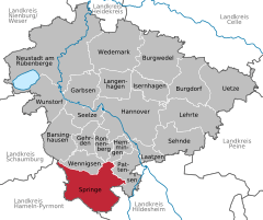
 | ||
| Coordinates: 52°13′N 9°33′E / 52.217°N 9.550°ECoordinates: 52°13′N 9°33′E / 52.217°N 9.550°E | ||
| Country | Germany | |
| State | Lower Saxony | |
| District | Hannover | |
| Government | ||
| • Mayor | Jörg-Roger Hische (CDU) | |
| Area | ||
| • Total | 159.78 km2 (61.69 sq mi) | |
| Population (2015-12-31)[1] | ||
| • Total | 28,682 | |
| • Density | 180/km2 (460/sq mi) | |
| Time zone | CET/CEST (UTC+1/+2) | |
| Postal codes | 31832 | |
| Dialling codes | 05041, 05044, 05045 | |
| Vehicle registration | H | |
| Website |
www | |

Springe is a town in the district of Hanover, in Lower Saxony, Germany. It is situated near the Deister hills, 22 kilometres (14 mi) southwest of Hanover.
Geography
City Structure
- Springe (core settlement, seat of the mayor), population 12,666
- Bennigsen, population 4,095
- Eldagsen, population 3,407
- Völksen, population 3,306
- Gestorf, population 1,870
- Altenhagen I, population 1,242
- Lüdersen, population 990
- Alferde, population 534
- Alvesrode, population 526
- Holtensen, population 471
- Mittelrode, population 315
- Boitzum, population 187
Current as of 1 March 2008.
History
Springe was first mentioned in 1013 as Hallerspringe. In a description of the borders of the Diocese of Hildesheim from an undated transcription, but which can be proven to be from the tenth century by its form and content, Springe was mentioned as Helereisprig. The Counts of Hallermund erected a fortress-like building on the land which is now Springe after the loss of Burg Hallermund on the Kleiner Deister to the House of Welf in 1282. They ruled their county from this new seat of power, which presumably resulted in the settlement of Springe. The creation of the Count's seat and the solidification of the location lead in the thirteenth century to the need for city laws. During the Middle Ages, Springe was the long-time seat of the Graves of Hallermund and their successors, a side lineage of the Grave of Käfernburg. From their area of rule, the office of Springe resulted and after different renamings and expansions, the Kreis Springe was formed in 1884.
By the end of the tenth century the first mentions of the names of the towns that today belong to Springe appear, and by the year 1300 all of the existing villages have been named.
The founding and growth of the area is connected with its location at the Deister Gate, a border between prairie and mountains, which is convenient for transportation in the middle of the route between Hanover and Hamelin. Further development resulted from the building of the "causeway" of what is today the B217 Highway in the 18th century and with the completion of the railroad line between Hanover and Altenbeken in 1872.
There was steady development towards a mid-sized city after the end of the First World War and even more so after the end of the Second World War ensued (in 1933 the population was 3,912). Up until the geographical reforms of 1974, Springe was the seat of the county of Springe. After that, Springe belonged to the county of Hanover, which became today's Region of Hanover on 1 November 2001. Today 13,000 residents live the core city of Springe. Because of reforms in the 13th century Eldagsen lost its rights as a city and is now a part of the City of Springe. After the inhabitants of Eldagsen protested, the town got its title of "city" back, and now bears the official title "City of Eldagsen, Part of the City of Springe".
Coat of Arms
The coat of arms of the city of Springe, according to a recent interpretation, represents the three sources of the Haller river, which begins close to the town at the foot of the Small Deister. The three corners of the shield each contain a five-petaled rose, which is the shield and seal symbol of the Shire of Hallermund, which existed from the twelfth century on.
International relations
Springe is twinned with:
- the city of Niort in France
- the city of Waren (Müritz) in Mecklenburg-Vorpommern.
Economy and Infrastructure
Transport
Springe lies on the Bundesstraße 217. Springe train station is on the Hannover–Altenbeken train line and is served by line 5 (Paderborn–Hamelin–Hannover Central Station–Hannover Airport) of the Hanover S-Bahn. RegioBus Hannover operates bus services in the city and to neighbouring locales.
Public Works
- Bison Nature Preserve (Wisentgehege)
- Klinikum Region Hannover GmbH, Springe Hospital
- Seat of the German Red Cross, Springe Chapter
- Seat of the German Red Cross, Region of Hanover
- Seat of the German Red Cross Emergency Service and both of its daughter companies.
- Seat of the German Red Cross Blood Donation, NSTOB.
- Indoor City Pool
- Burghof Museum, Springe
- Outdoor municipal pools in Altenhagen I, Bennigsen und Eldagsen
- Public sport clubs in all divisions of the city
- Tennis facilities, mini golf, bowling, beach volleyball, and skating facilities
Public Figures
Famous Persons from Springe
- Johann Heinrich Schröder, * 1646 in Springe, † 1699 in Meseberg bei Magdeburg, hymn writer and theologian (Lutheran hymnal)
- Heinrich Göbel, * 20 April 1818 in Springe; † 4 December 1893 in New York, United States; also known after 1849 as Henry Goebel; claimed he was the inventor of the lightbulb prior to Thomas Alva Edison's patent in 1880.
- Carl Dopmeyer, * 24 October 1824 in Springe, † 9. November 1899 in Hannover, Hanoverian sculptor of the Luther Memorial and the Gänseliesel.
- Herbert Ihering, * 29 February 1888 in Springe, † 15. January 1977 in Berlin, aka Herbert Jhering, was a German playwright, movie director, journalist, and theatre critic.
- Heinrich Hüper (1898–1983) was a teacher and author, who wrote in high German as well as in the Eastphalian dialect.
- Olivia Jones, born Oliver Knöbel on 21 November 1970, artist.
- Andi Slawinski (* 1976), actor.
References
- ↑ Landesbetrieb für Statistik und Kommunikationstechnologie Niedersachsen, 102 Bevölkerung - Basis Zensus 2011, Stand 31. Dezember 2015 (Tabelle K1020014)
External links
| Wikimedia Commons has media related to Springe. |
Towns and municipalities in Hanover Region | ||
|---|---|---|