Spondon
| Spondon | |
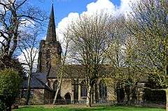 St Werburgh's Church |
|
 Spondon |
|
| Area | 7.97 km2 (3.08 sq mi) [1] |
|---|---|
| Population | 12,377 (2011)[1] |
| – density | 1,553/km2 (4,020/sq mi) |
| OS grid reference | SK403360 |
| District | Derby |
| Shire county | Derbyshire |
| Region | East Midlands |
| Country | England |
| Sovereign state | United Kingdom |
| Post town | DERBY |
| Postcode district | DE21 |
| Police | Derbyshire |
| Fire | Derbyshire |
| Ambulance | East Midlands |
| EU Parliament | East Midlands |
| UK Parliament | Mid Derbyshire |
|
|
Coordinates: 52°55′12″N 1°24′04″W / 52.92°N 1.401°W


Spondon is a village in the east of the city of Derby. The original village dates back to the Domesday Book but the area became heavily industrialised in the 19th and early 20th centuries, with companies such as British Celanese (now Celanese Corporation) who made cellulose acetate in World War I and later artificial fibres.
History
The name Spondon is Anglo-Saxon and describes a gravelly hill. The village is mentioned in the Domesday Book of 1086.[2] In about 1333,[3] a great fire, starting at The Malt Shovel, a local pub, and aided by an easterly wind, swept through the village destroying the church and all but a few houses, with just one casualty, the mayor. The damage was so great that a judge, Roger de Bankwell, was sent to hear pleas for relief from taxes.[3] The Great Fire of Spondon is still commemorated and taught as part of the curriculum in local schools. A village fair was held on its 650th anniversary (circa.1990).
Government
Spondon is part of the Mid Derbyshire constituency for Westminster elections.
Geography
The community lies on the north slope of the valley of the River Derwent east of Derby and is divided by the A52, which separates the residential Spondon village area at the top of the hill from the heavily industrialised area at the bottom.
Demography
At the census in 2011 Spondon had a population of 12,377 of which 94.6% were White British, compared to 75.3% for Derby as a whole.[1]
Economy
The industrial belt lies to the south of the Nottingham Road (an old Roman road) as does the canal and the railway. These barriers separate the residential three quarters of the village from its industrial quarter. The various industries have included a dye works, electricity generating station, two scrapyards, sewerage works, British Celanese synthetic fibres works and a tannery.
Spondon holds a small number of chain shops but continues to support the business of many independent tradespeople too, including a men's barbers, a gift shop and a bakery. Chapel Street and Sitwell Street (in the centre) are the main areas of this retail activity. Dale Road (north-east) and Nottingham Road (south) also have a row of shops. Superstores (Asda off Nottingham Road (south-west) are also in Spondon.
Culture and community
There are many clubs/groups/societies serving Spondon. The Spondon Village Festival (Carnival) was first held in 2010 and is hoped that it will become an annual event combining carnival and fair. Spondon won the Urban Community award from Britain in Bloom in 2005.
Facilities - one library, two social clubs, six public houses (the names and numbers have not changed since 1961).
Parks - Brunswood (playground + playing field), Dale Road (field + landscaping), South Avenue Rec (playground + field), Gravel Pit Lane (playing field), Locko Park (country park), Spondon Woods (woods + scrub), Stony Cross (woods + scrub), Willowcroft (playing field) .
Venues - Asterdale Club (formerly the Celanese Workers' Club), club grounds, village parks, village hall, old school hall.
Landmarks
The historic centre of the village is designated as a conservation area. Locko Park is a Grade II*-listed mansion dating from 1669. The Homestead is a large detached Georgian mansion on Sitwell Street. The Stone Archways in Park Road mark the entrance to the now demolished Spondon House. The Enoch Stone Memorial marks the spot on Nottingham Road where a notorious murder took place in 1856.[4]
Transport
Derby Canal (Derby - Sandiacre) opened in 1795, and enabled other industries. The canal closed in 1964. There was talk of reopening for leisure purposes, but without progress (in 2010).[5]
The Midland Counties Railway opened a line from Derby to Nottingham in 1839.[6] This line became part of the Midland Main Line to London St Pancras railway station. Spondon railway station has a rather limited service to both Derby and Nottingham.
The A52, 'Borrowash by-pass' named Brian Clough Way, cuts through the village and provides express road (dual-carriageway) links to the west (Derby) and the east (M1 and Nottingham). Regional Cycle Route 66 links Spondon to Chaddesden and Alvaston.
Education
There are five state schools located in the village. Primary Schools - Asterdale (south-east), Borrowood (north-east), St.Werburgh's C of E and Springfield.
Secondary Schools - West Park School.
West Park School represents the merger by default (fire/arson, 28/01/2002) of the former Spondon School (seniors) (State Comprehensive) which was located on two adjoining sites. These sites being the 'upper school' (1960s, grey brick, concrete and glass) at the top of the hillside, the current site, and the 'lower school' (1970s, grey brick, brown tile, timber and glass) at the foot of the hillside, which burned down. The new name comes from the two roads which lead to it.
Religious sites
St. Werburgh's Church dates from around 1390, replacing an earlier church destroyed by fire in 1340.[7] In the churchyard is an Anglo-Saxon cross dating from c.870.
Sport
Spondon Cricket Club,[8] Spondon Dynamos Football Club,[9] Bowls club, Snooker club.
Notable people
Born in Spondon -
- Anthony Borrington, cricketer.
- Rowena Cade, founder Minack Theatre.
- Donna Kellogg, Badminton Player.
- Michael Knowles, actor.
- James Herbert Matthews, member of Canadian parliament.
- Robert Priseman, artist.[10][11]
- William Thompson, cricketer.
- Ashley Clarke
Links to Spondon -
- Ray Colledge, mountaineer who made the third British ascent of the North Face of the Eiger in 1969.
- Graham Coxon, guitarist with Blur.
- Drury Curzon Drury-Lowe, lieutenant-general and knight of the realm.
- Henry Evans, cricketer.
- Sir Henry Fowler,[12] Chief Engineer for the London Midland and Scottish Railway.
- Richard William Hunt, Keeper of the Western Manuscripts, Bodleian Library.
- George Porter, cricketer.
See also
References
- 1 2 3 "Spondon Profile 2011/12" (PDF). Derby council. p. 17.
- ↑ Domesday Book: A Complete Translation. London: Penguin, 2003. ISBN 0-14-143994-7 p.748
- 1 2 Roger de Bankwell at Dictionary of National Biography now in the public domain
- ↑ http://www.spondononline.co.uk/murder-enoch-stone
- ↑ Derby Canal
- ↑ Midland Counties Railway
- ↑ St Werburghs church site
- ↑ http://www.spondoncricketclub.co.uk
- ↑ http://www.spondondynamosfc.co.uk/
- ↑ Peppiatt, M. & Priseman, R. (2011). The Francis Bacon Interiors. Seabrook Press. ISBN 978-0956208224.
- ↑ Priseman, R. et. al. (2009). No Human Way To Kill. Seabrook Press. ISBN 978-0956208248.
- ↑ "Spondon, Derby". Derbyshire Life. Retrieved 24 January 2012.
| Wikimedia Commons has media related to Spondon. |
External links
- Spondon Online
- Spondon Community Association
- A Village Remembered
- Spondon Community Walk map
- Spondon Village Festival
- Spondon Historical Society
- Derby Guide - Spondon