Spodnje Loke
| Spodnje Loke | |
|---|---|
|
Postcard of Spodnje Loke | |
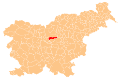
 Spodnje Loke Location in Slovenia | |
| Coordinates: 46°10′1.93″N 14°45′51.99″E / 46.1672028°N 14.7644417°ECoordinates: 46°10′1.93″N 14°45′51.99″E / 46.1672028°N 14.7644417°E | |
| Country |
|
| Traditional region | Upper Carniola |
| Statistical region | Central Slovenia |
| Municipality | Lukovica |
| Area | |
| • Total | 1.09 km2 (0.42 sq mi) |
| Elevation | 380.5 m (1,248.4 ft) |
| Population (2002) | |
| • Total | 106 |
| [1] | |

Spodnje Loke (pronounced [ˈspoːdnjɛ ˈloːkɛ] or [ˈspoːdnjɛ ˈlɔːkɛ]) is a settlement east of Krašnja on the main road from Ljubljana to Celje in the eastern part of the Upper Carniola region of Slovenia. It is in the municipality of Lukovica.[2]
References
External links
This article is issued from Wikipedia - version of the 6/28/2015. The text is available under the Creative Commons Attribution/Share Alike but additional terms may apply for the media files.