Spitzingsee
| Spitzingsee | |
|---|---|
 | |
| Location | Schliersee Mountains, Bavaria |
| Coordinates | 47°39′58″N 11°53′12″E / 47.66611°N 11.88667°ECoordinates: 47°39′58″N 11°53′12″E / 47.66611°N 11.88667°E |
| Primary inflows | Lochgraben, Firstgraben |
| Primary outflows | Rote Valepp |
| Basin countries | Germany |
| Max. length | 950 m (3,120 ft) |
| Max. width | 300 m (980 ft) |
| Surface area | 28.3 ha (70 acres) |
| Average depth | 7.24 m (23.8 ft) |
| Max. depth | 16.30 m (53.5 ft) |
| Water volume | 2,049,000 m3 (72,400,000 cu ft) |
| Shore length1 | 2.9 km (1.8 mi) |
| Surface elevation | 1,084 m (3,556 ft) |
| 1 Shore length is not a well-defined measure. | |
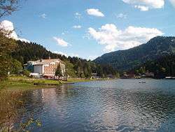
Spitzingsee is a lake in Bavaria, Germany. At an elevation of 1084 m, its surface area is 28.3 ha.
It is also the name for a settlement within Marktgemeinde Schliersee which is part of Landkreis Miesbach.
![]() Media related to Spitzingsee at Wikimedia Commons
Media related to Spitzingsee at Wikimedia Commons
| Wikivoyage has a travel guide for Spitzingsee. |
This article is issued from Wikipedia - version of the 9/4/2015. The text is available under the Creative Commons Attribution/Share Alike but additional terms may apply for the media files.