Speicherstadt
| Speicherstadt | |
|---|---|
|
View of Wandrahmsfleet at night | |
| General information | |
| Type | warehouse district |
| Architectural style | Gothic Revival |
| Location | Hamburg, Germany |
| Construction started | 1883 |
| Completed | 1927 |
| Opened | 1888 |
| Owner | Free and Hanseatic City of Hamburg |
| Dimensions | |
| Other dimensions | 1,500 m × 250 m |
| Technical details | |
| Material | red brick |
| Size | 26 hectares (0.26 km2) |
| Floor area | 630,000 m2 (6,800,000 sq ft) |
| Design and construction | |
| Architect | Carl Johann Christian Zimmermann |
| Engineer | Franz Andreas Meyer |
| Official name | Speicherstadt |
| Type | cultural |
| Criteria | iv |
| Designated | 2015 |
| Part of | Speicherstadt and Kontorhaus District with Chilehaus |
| Reference no. | 1467 |

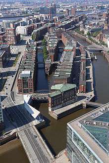
The Speicherstadt (German pronunciation: [ˈʃpaɪ̯çɐˌʃtat], literally: 'City of Warehouses', meaning warehouse district) in Hamburg, Germany is the largest warehouse district in the world where the buildings stand on timber-pile foundations, oak logs, in this particular case. It is located in the port of Hamburg—within the HafenCity quarter—and was built from 1883 to 1927.
The district was built as a free zone to transfer goods without paying customs. As of 2009 the district and the surrounding area is under redevelopment. As the first site in Hamburg, it has been awarded the status of UNESCO World Heritage Site on 5 July 2015.
Geography
The Speicherstadt is located in the port of Hamburg. It is 1.5 km (0.93 mi) long and interlaced by loading canals (Low German: Fleets).
History
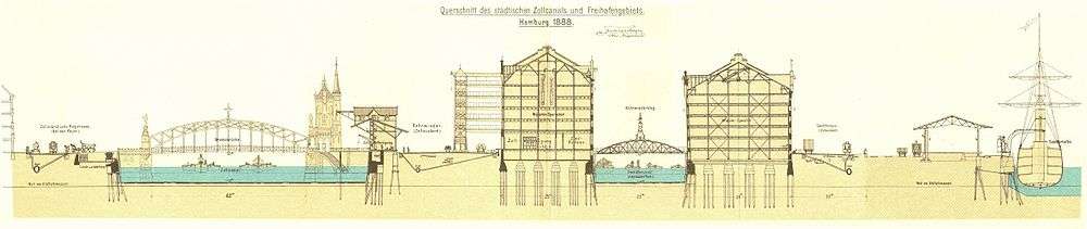
Since 1815, the independent and sovereign city of Hamburg was a member of the German Confederation—the association of Central European states created by the Congress of Vienna—but not member of the German Customs Union. With the establishment of the German Empire in 1871, Hamburg could not be a customs free zone and part of the German Empire. Due to treaties of 1888 Hamburg was part of the German customs zone and a free port was established.[1]
In 1883, the demolition of the Kehrwieder area began and more than 20,000 people needed to be relocated. From 1885 to 1888 the first part was built and managed by the Freihafen-Lagerhaus-Gesellschaft (the predecessor of the Hamburger Hafen und Logistik AG). In 1991 it was listed as a protected Hamburg heritage site,[2] and since 2008, it has been part of the HafenCity quarter.[3] In an attempt to revitalize the inner city area, the Hamburg government initiated the development of the HafenCity area, for example with the construction of the Elbe Philharmonic Hall.[4]
In World War II, Allied bombing destroyed around 50% of the Speicherstadt. Some of the structures completely destroyed were not rebuilt. They are now the location of the Hanseatic Trade Center.[5]:13
Architecture

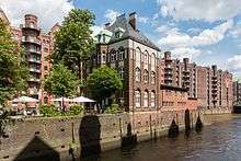
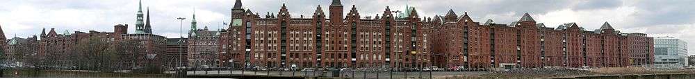
The warehouses were built with different support structures, but Andreas Meyer created a Neo-Gothic red-brick outer layer with little towers, alcoves, and glazed terra cotta ornaments. The warehouses are multi-storey buildings with entrances from water and land.[2] One of the oldest warehouses is the Kaispeicher B of the International Maritime Museum.

Use
The Speicherstadt is a tourist attraction in Hamburg. There are several museums like the Deutsches Zollmuseum (German Customs Museum), Miniatur Wunderland (a model railway) and the Hamburg Dungeon. The Afghan Museum was also located here, but closed in 2011.
The buildings are also used as warehouses. As of 2005, the companies in the Speicherstadt handled one-third of the world's carpet production, and other goods including cocoa, coffee, tea, spices, maritime equipment, and electronics.[2]
See also
References
- ↑ Prange, Carsten (2005). "Zollanschluß". In Franklin Koplitzsch and Daniel Tilgner. Hamburg Lexikon (in German) (3 ed.). Ellert&Richter. p. 538. ISBN 3-8319-0179-1.
- 1 2 3 Prange, Carsten (2005). "Speicherstadt". In Franklin Koplitzsch and Daniel Tilgner. Hamburg Lexikon (in German) (3 ed.). Ellert&Richter. pp. 444–445. ISBN 3-8319-0179-1.
- ↑ "Gesetz über die räumliche Gliederung der Freien und Hansestadt Hamburg (RäumGiG) [Act of the areal organisation]" (in German). 2006-07-06. Retrieved 2009-10-30.
- ↑ Jörn Weinhold (2008). Martina Heßler and Clemens Zimmermann, ed. Port Culture: Maritime Entertainment and Urban Revitalisation, 1950–2000. Frankfurt am Main: Campus Verlag. pp. 179–201. ISBN 978-3-593-38547-1.
- ↑ "Speicherstadt Hamburg Entwicklungskonzept (German)" (PDF). Hamburg Behörde für Stadtentwicklung und Umwelt. April 2012. Retrieved 5 July 2015.
Bibliography
- Batz, M. (2002). "Urbane Light Germany Speicherstadt, Hamburg, the largest historical warehouse complex in the world, has become a softly-glowing night-time panorama". International Lighting Review (12,): 14–19. OCLC 193350885.
- Lawrenz, Dierk; von Borstel, Christiane (2008). Die Hamburger Speicherstadt (in German). Freiburg, Br: EK-Verlag. ISBN 978-3-88255-893-7.
- Meyn, Boris (2003). Die rote Stadt: ein historischer Kriminalroman (in German). Reinbek: Rowohlt. ISBN 978-3-499-23407-1. A historical detective story.
- Lange, Ralf; Hampel, Thomas (2004). Speicherstadt und HafenCity: zwischen Tradition und Vision (in German). Hamburg: Elbe-und-Flut-Ed., Hampel und Hettchen. ISBN 978-3-7672-1440-8.
External links
![]() Media related to Speicherstadt at Wikimedia Commons
Media related to Speicherstadt at Wikimedia Commons
Freie und Hansestadt Hamburg | |
| Government and Symbols | |
| History and Culture | |
| Economy and Transport | |
Coordinates: 53°32′36″N 9°59′31″E / 53.54333°N 9.99194°E