Southampton, Massachusetts
| Southampton, Massachusetts | ||
|---|---|---|
| Town | ||
|
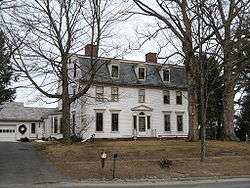
Woodbridge Hall | ||
| ||
 Location in Hampshire County in Massachusetts | ||
| Coordinates: 42°13′45″N 72°43′50″W / 42.22917°N 72.73056°WCoordinates: 42°13′45″N 72°43′50″W / 42.22917°N 72.73056°W | ||
| Country | United States | |
| State | Massachusetts | |
| County | Hampshire | |
| Settled | 1732 | |
| Incorporated | 1775 | |
| Government | ||
| • Type | Open town meeting | |
| Area | ||
| • Total | 29.1 sq mi (75.3 km2) | |
| • Land | 28.2 sq mi (72.9 km2) | |
| • Water | 0.9 sq mi (2.4 km2) | |
| Elevation | 230 ft (70 m) | |
| Population (2010) | ||
| • Total | 5,792 | |
| • Density | 191.4/sq mi (73.9/km2) | |
| Time zone | Eastern (UTC-5) | |
| • Summer (DST) | Eastern (UTC-4) | |
| ZIP code | 01073 | |
| Area code(s) | 413 | |
| FIPS code | 25-62745 | |
| GNIS feature ID | 0618207 | |
| Website | ||

Southampton (![]() i/saʊθˈhæmptən/)[1] is a town in Hampshire County, Massachusetts, United States. It was established first as a district of Northampton in 1753. It was incorporated in 1753. The name Southampton was given to it during its first town meeting in 1773. Its ZIP code is 01073. Southampton is part of the Springfield, Massachusetts Metropolitan Statistical Area. The town had a population of 5,792 at the 2010 census.
i/saʊθˈhæmptən/)[1] is a town in Hampshire County, Massachusetts, United States. It was established first as a district of Northampton in 1753. It was incorporated in 1753. The name Southampton was given to it during its first town meeting in 1773. Its ZIP code is 01073. Southampton is part of the Springfield, Massachusetts Metropolitan Statistical Area. The town had a population of 5,792 at the 2010 census.
Southampton was rated having the best tasting tap water in the country in 2008 by the National Rural Water Association.[2]
U.S. Senator Ted Kennedy was involved in a plane crash there in 1964.[3]
Lewis Strong Clarke, a Louisiana sugarcane planter and 19th century Republican politician, was born there in 1837.[4]
Geography
According to the United States Census Bureau, the town has a total area of 29.1 square miles (75 km2), of which 28.1 square miles (73 km2) is land and 0.9 square miles (2.3 km2) (3.20%) is water. Southampton is bordered by Easthampton to the northeast, Holyoke to the southeast, Westfield to the south, Montgomery to the southwest, Huntington for a very short length on the west, and Westhampton to the northwest. Southampton is located 17 miles northwest of Springfield and 100 miles to the west of Boston.
Demographics
| Historical population | ||
|---|---|---|
| Year | Pop. | ±% |
| 1850 | 1,060 | — |
| 1860 | 1,130 | +6.6% |
| 1870 | 1,159 | +2.6% |
| 1880 | 1,046 | −9.7% |
| 1890 | 1,017 | −2.8% |
| 1900 | 1,012 | −0.5% |
| 1910 | 870 | −14.0% |
| 1920 | 814 | −6.4% |
| 1930 | 931 | +14.4% |
| 1940 | 950 | +2.0% |
| 1950 | 1,387 | +46.0% |
| 1960 | 2,192 | +58.0% |
| 1970 | 3,069 | +40.0% |
| 1980 | 4,137 | +34.8% |
| 1990 | 4,478 | +8.2% |
| 2000 | 5,387 | +20.3% |
| 2010 | 5,792 | +7.5% |
As of the census of 2000, there were 5,387 people, 1,985 households, and 1,556 families residing in the town. The population density was 191.4 people per square mile (73.9/km²). There were 2,025 housing units at an average density of 71.9 per square mile (27.8/km²). The racial makeup of the town was 98.29% White, 0.20% African American, 0.13% Native American, 0.63% Asian, 0.20% from other races, and 0.54% from two or more races. Hispanic or Latino of any race were 0.87% of the population.
There were 1,985 households out of which 36.6% had children under the age of 18 living with them, 66.9% were married couples living together, 8.4% had a female householder with no husband present, and 21.6% were non-families. 16.8% of all households were made up of individuals and 6.8% had someone living alone who was 65 years of age or older. The average household size was 2.71 and the average family size was 3.07.
In the town the population was spread out with 25.5% under the age of 18, 6.3% from 18 to 24, 29.1% from 25 to 44, 29.2% from 45 to 64, and 9.9% who were 65 years of age or older. The median age was 39 years. For every 100 females there were 94.3 males. For every 100 females age 18 and over, there were 95.0 males.
The median income for a household in the town was $61,831, and the median income for a family was $64,960. Males had a median income of $41,544 versus $31,250 for females. The per capita income for the town was $26,205. About 1.8% of families and 2.4% of the population were below the poverty line, including 2.8% of those under age 18 and 6.5% of those age 65 or over.
References
- ↑ "Southampton". Dictionary.com Unabridged. Random House. Retrieved 15 November 2014.
- ↑ "Massachusetts town tapped for nation's best water". CNN. April 22, 2008.
- ↑ http://www.masslive.com/news/index.ssf/2009/08/plane_crash_in_southampton_in.html
- ↑ "Clarke, Lewis Strong". Louisiana Historical Association, A Dictionary of Louisiana Biography (lahistory.com). Retrieved December 21, 2010.
External links
| Wikimedia Commons has media related to Southampton, Massachusetts. |
Municipalities and communities of Hampshire County, Massachusetts, United States | ||
|---|---|---|
| Cities | 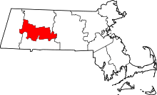 | |
| Towns | ||
| CDPs | ||
| Other villages | ||
| Footnotes | ‡This populated place also has portions in an adjacent county or counties | |