South Thanet (UK Parliament constituency)
| South Thanet | |
|---|---|
|
County constituency for the House of Commons | |
|
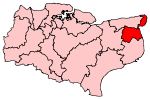
Boundary of South Thanet in Kent. | |
|
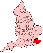
Location of Kent within England. | |
| County | Kent |
| Electorate | 67,970 (December 2010)[1] |
| Major settlements | Ramsgate, Broadstairs and Sandwich |
| Current constituency | |
| Created | 1983 |
| Member of parliament | Craig Mackinlay (Conservative) |
| Number of members | One |
| Created from | Thanet West, Dover & Deal and Thanet East[2] |
| Overlaps | |
| European Parliament constituency | South East England |
South Thanet is a constituency[n 1] represented in the House of Commons of the UK parliament since 2015 by Craig Mackinlay MP, a Conservative.[n 2]
Constituency profile
Tourism is an important economic activity with entertainment and beaches, particularly at Broadstairs. The constituency also includes part of the Stour Valley Walk, which passes through Sandwich on its way to Canterbury and beyond. There are picturesque villages with oast houses. The amount of fishing and coastal trade is much reduced relative to the 19th century, and is small compared to many other British ports. The seat has a higher proportion of retired people than the national average[3] and incomes tend to be clustered around the national mean.[4] Economic developments have included the nearby Thanet Offshore Wind Project as well as commercial, recreational and tourism activities. Farming, trades, and Ramsgate harbour provide much of the employment. Pharmaceuticals received a blow when Pfizer withdrew from the area. The unemployed claimant count, at 5.4%, was the highest of the South East's 84 constituencies at the end of 2010, and greater than the national average of 3.8%.[n 3][5] Since its creation in 1983 the seat has been a bellwether.
Boundaries
1983-2010: The District of Thanet wards of Beacon Road, Bradstowe, Central Eastcliff, Central Westcliff, Kingsgate, Minster Parish, Newington, Northwood, Pierremont, St Lawrence, St Peter's, Sir Moses Montefiore, Southwood, and Upton, and the District of Dover wards of Ash, Little Stour, Sandwich, Woodnesborough with Staple, and Worth.
2010-present: The District of Thanet wards of Beacon Road, Bradstowe, Central Harbour, Cliffsend and Pegwell, Cliftonville East, Cliftonville West, Eastcliff, Kingsgate, Nethercourt, Newington, Northwood, St Peter's, Sir Moses Montefiore, and Viking, and the District of Dover wards of Little Stour and Ashstone, and Sandwich.
South Thanet consists of the southern and eastern part of Thanet district (the towns of Ramsgate and Broadstairs, the Cliftonville area of Margate and the village of Cliffsend) together with the northern part of Dover district, comprising the ancient Cinque Port of Sandwich and surrounding villages.
Members of Parliament
| Election | Member[6] | Party | |
|---|---|---|---|
| 1983 | Jonathan Aitken | Conservative | |
| 1997 | Stephen Ladyman | Labour | |
| 2010 | Laura Sandys | Conservative | |
| 2015 | Craig Mackinlay | Conservative | |
Elections
Elections in the 2010s
| Party | Candidate | Votes | % | ± | |
|---|---|---|---|---|---|
| Conservative | Craig Mackinlay | 18,838 | 38.1 | −9.9 | |
| UKIP | Nigel Farage | 16,026 | 32.4 | +26.9 | |
| Labour | Will Scobie | 11,740 | 23.8 | −7.6 | |
| Green | Ian Driver | 1,076 | 2.2 | N/A | |
| Liberal Democrat | Russell Timpson | 932 | 1.9 | −13.2 | |
| No description1 | Al Murray | 318 | 0.6 | N/A | |
| Manston Airport Independent | Ruth Bailey | 191 | 0.4 | N/A | |
| We Are The Reality Party | Nigel Askew | 126 | 0.3 | N/A | |
| Party for a United Thanet | Grahame Birchall | 63 | 0.1 | N/A | |
| Independent | Dean McCastree | 61 | 0.1 | N/A | |
| Al-Zebabist Nation of Ooog | Robert George Zebadiah Abu-Obadiah | 30 | 0.05 | N/A | |
| Majority | 2,812 | 5.7 | −10.9 | ||
| Turnout | 49,401 | 70.4 | +5.1 | ||
| Conservative hold | Swing | −18.4 | |||
1: Murray appeared on the ballot paper without any description,[9] but campaigned under the label of the Free United Kingdom Party (FUKP).[10]
| Party | Candidate | Votes | % | ± | |
|---|---|---|---|---|---|
| Conservative | Laura Sandys | 22,043 | 48.0 | +6.8 | |
| Labour | Stephen Ladyman | 14,426 | 31.4 | −8.1 | |
| Liberal Democrat | Peter Bucklitsch | 6,935 | 15.1 | +2.9 | |
| UKIP | Trevor Shonk | 2,529 | 5.5 | +0.7 | |
| Majority | 7,617 | 16.6 | |||
| Turnout | 45,933 | 65.3 | 0.2 | ||
| Conservative gain from Labour | Swing | +7.4 | |||
Elections in the 2000s
| Party | Candidate | Votes | % | ± | |
|---|---|---|---|---|---|
| Labour | Stephen Ladyman | 16,660 | 40.4 | −5.3 | |
| Conservative | Mark MacGregor | 15,996 | 38.8 | −2.3 | |
| Liberal Democrat | Guy Voizey | 5,431 | 13.2 | +3.8 | |
| UKIP | Nigel Farage | 2,079 | 5.0 | +3.7 | |
| Green | Howard Green | 888 | 2.2 | +2.2 | |
| Independent | Maude Kinsella | 188 | 0.5 | +0.5 | |
| Majority | 664 | 1.6 | |||
| Turnout | 41,242 | 65 | 1.1 | ||
| Labour hold | Swing | −1.5 | |||
| Party | Candidate | Votes | % | ± | |
|---|---|---|---|---|---|
| Labour | Stephen Ladyman | 18,002 | 45.7 | −0.5 | |
| Conservative | Mark MacGregor | 16,210 | 41.1 | +1.3 | |
| Liberal Democrat | Guy Voizey | 3,706 | 9.4 | −2.3 | |
| Independent | William Baldwin | 770 | 2.0 | N/A | |
| UKIP | Terry Eccott | 502 | 1.3 | N/A | |
| National Front | Bernard Franklin | 242 | 0.6 | N/A | |
| Majority | 1,792 | 4.6 | |||
| Turnout | 39,432 | 63.9 | −7.7 | ||
| Labour hold | Swing | ||||
Elections in the 1990s
| Party | Candidate | Votes | % | ± | |
|---|---|---|---|---|---|
| Labour | Stephen Ladyman | 20,777 | 46.2 | +18.1 | |
| Conservative | Jonathan Aitken | 17,899 | 39.8 | −11.9 | |
| Liberal Democrat | Barbara Hewitt-Silk | 5,263 | 11.7 | −6.6 | |
| Independent | C Crook | 631 | 1.4 | N/A | |
| Green | David Wheatley | 418 | 0.9 | −0.9 | |
| Majority | 2,878 | 6.4 | |||
| Turnout | 44,488 | 71.6 | |||
| Labour gain from Conservative | Swing | ||||
| Party | Candidate | Votes | % | ± | |
|---|---|---|---|---|---|
| Conservative | Jonathan Aitken | 25,253 | 51.7 | −2.6 | |
| Labour | Mark Stephen James | 13,740 | 28.1 | +7.2 | |
| Liberal Democrat | Bill Pitt | 8,948 | 18.3 | −6.4 | |
| Green | Ms. Sue Peckham | 871 | 1.8 | N/A | |
| Majority | 11,513 | 23.6 | −6.0 | ||
| Turnout | 48,812 | 78.2 | +4.5 | ||
| Conservative hold | Swing | −4.9 | |||
Elections in the 1980s
| Party | Candidate | Votes | % | ± | |
|---|---|---|---|---|---|
| Conservative | Jonathan Aitken | 25,135 | 54.3 | −2.2 | |
| Liberal | Bill Pitt | 11,452 | 24.8 | +0.7 | |
| Labour | Chris Wright | 9,673 | 20.9 | +1.5 | |
| Majority | 13,683 | 29.6 | −2.8 | ||
| Turnout | 46,260 | 73.7 | +3.7 | ||
| Conservative hold | Swing | −1.4 | |||
| Party | Candidate | Votes | % | ± | |
|---|---|---|---|---|---|
| Conservative | Jonathan Aitken | 24,512 | 56.5 | N/A | |
| Liberal | Ian Richard Philip Josephs | 10,461 | 24.1 | N/A | |
| Labour | Martin Andrew Clark | 8,429 | 19.4 | N/A | |
| Majority | 14,051 | 32.4 | N/A | ||
| Turnout | 43,402 | 70.0 | N/A | ||
| Conservative win (new seat) | |||||
See also
Notes and references
- Notes
- ↑ A county constituency (for the purposes of election expenses and type of returning officer)
- ↑ As with all constituencies, the constituency elects one Member of Parliament (MP) by the first past the post system of election at least every five years.
- ↑ Third and second were North Thanet and Hastings and Rye
- References
- ↑ "Electorate Figures - Boundary Commission for England". 2011 Electorate Figures. Boundary Commission for England. 4 March 2011. Archived from the original on 6 November 2010. Retrieved 13 March 2011.
- ↑ "'Thanet South', June 1983 up to May 1997". ElectionWeb Project. Cognitive Computing Limited. Retrieved 14 March 2016.
- ↑ "2011 Census Interactive - ONS". Ons.gov.uk. Archived from the original on 29 January 2016. Retrieved 14 January 2015.
- ↑ "Check Browser Settings". Neighbourhood.statistics.gov.uk. Retrieved 14 January 2015.
- ↑ Unemployment claimants by constituency The Guardian
- ↑ Leigh Rayment's Historical List of MPs – Constituencies beginning with "T" (part 1)
- ↑ "Election Data 2015". Electoral Calculus. Archived from the original on 17 October 2015. Retrieved 17 October 2015.
- ↑ "Statement of the persons nominated for election as a Member of Parliament for South Thanet Constituency". Thanet District Council.
- ↑ "Archived copy". Archived from the original on 7 May 2015. Retrieved 2015-04-26.
- ↑ "Thanet South parliamentary constituency". BBC News. Retrieved 2016-10-25.
- ↑ "Election Data 2010". Electoral Calculus. Archived from the original on 26 July 2013. Retrieved 17 October 2015.
- ↑ "Election Data 2005". Electoral Calculus. Archived from the original on 15 October 2011. Retrieved 18 October 2015.
- ↑ "Election Data 2001". Electoral Calculus. Archived from the original on 15 October 2011. Retrieved 18 October 2015.
- ↑ "Election Data 1997". Electoral Calculus. Archived from the original on 15 October 2011. Retrieved 18 October 2015.
- ↑ "Election Data 1992". Electoral Calculus. Archived from the original on 15 October 2011. Retrieved 18 October 2015.
- ↑ "Politics Resources". Election 1992. Politics Resources. 9 April 1992. Retrieved 2010-12-06.
- ↑ "Election Data 1987". Electoral Calculus. Archived from the original on 15 October 2011. Retrieved 18 October 2015.
- ↑ "Election Data 1983". Electoral Calculus. Archived from the original on 15 October 2011. Retrieved 18 October 2015.
Coordinates: 51°18′N 1°22′E / 51.300°N 1.367°E