South Salt Lake, Utah
| South Salt Lake, Utah | |
|---|---|
| City | |
| City of South Salt Lake | |
|
South Salt Lake City Hall, South Salt Lake, Utah | |
| Motto: City on the Move | |
 Location in Salt Lake County and the state of Utah. | |
| Coordinates: 40°42′28″N 111°53′21″W / 40.70778°N 111.88917°WCoordinates: 40°42′28″N 111°53′21″W / 40.70778°N 111.88917°W | |
| Country | United States |
| State | Utah |
| County | Salt Lake |
| Settled | 1847 |
| Incorporated | 1938 |
| Named for | Great Salt Lake |
| Area | |
| • Total | 6.9 sq mi (17.9 km2) |
| • Land | 6.9 sq mi (17.9 km2) |
| • Water | 0.0 sq mi (0.0 km2) |
| Elevation | 4,255 ft (1,297 m) |
| Population (2012) | |
| • Total | 24,366 |
| • Density | 3,190.8/sq mi (1,232.0/km2) |
| Time zone | Mountain (MST) (UTC-7) |
| • Summer (DST) | MDT (UTC-6) |
| ZIP codes | 84106, 84115 |
| Area code(s) | 385, 801 |
| FIPS code | 49-71070[1] |
| GNIS feature ID | 1432753[2] |
| Website | http://southsaltlakecity.com |

South Salt Lake is a city in Salt Lake County, Utah, United States and is part of the Salt Lake City Metropolitan Statistical Area. The population was 23,617 at the 2010 census.
History
Incorporated in 1938, South Salt Lake celebrated its 75th-year Diamond Anniversary in 2013.[3] Nestled among and often confused for neighboring larger cities, it is close to everything from golf courses to a downtown night life while still maintaining its small town feel. Some of Utah's best ski resorts are about a 30-minute drive and downtown Salt Lake City is only several minutes away. South Salt Lake offers mass transportation, various housing types; parochial, charter, and public schools; city parks, and one of the most diverse populations in Utah.Originally, South Salt Lake was made up of three distinct unincorporated areas: Millcreek to the north, Central Park and Southgate to the south. In 1936 Central Park incorporated as its own town.
Jesse Fox Jr. developed the area South Salt Lake refers to as Central Park around 1890. It runs approximately from State Street to 300 East and 2500 South to 3000 South.
Mr. Fox chose the name after visiting New York and seeing Central Park there. He was impressed by the park, and the urban planning. He wanted his development to be related to the status of the Central Park in New York. South Salt Lake was a rural place at the time but he was so impressed at what he saw back east, he wanted to make a connection to the development here.
A few of the street names in the neighborhood have a connection to Mr. Fox. He had a daughter named Esther Vidas Fox, and another named Lucy Beryl Fox. There was no daughter named Leslie. However, there was a close relative, Lester Fox who went by Leslie and so Leslie Avenue is named after him.
In 1925 the LDS Central Park Ward was created and named after the development. On August 14, 1936 a resolution creating the Town of Central Park was approved by the Board of County Commissioners. There were 37 pages of signatures in favor of incorporating the town. "On or about July 15, 1937, one-fourth or more of the legal voters of said Town of Central Park, Utah" petitioned to disincorporate the town. On November 2, 1937, 1013 votes were cast, 731 were for the dis-incorporation. Almost a year later the Town of South Salt Lake was established in September 1938.
The property formerly known as Woodrow Wilson Elementary was renamed Central Park Community Center to reflect the history in the area. It boasts a ball diamond, a playground, a Head Start Pre-School, and the Pete Suazo Boxing Gym. Every day you can see kids playing soccer, or baseball, animal lovers with their dogs, joggers and families enjoying the open space.[4]
On Thursday, September 29, 1938 a meeting was called to order at 8:30 p.m. by Robert R. Fitts. Also in attendance at this meeting were Alma Kasteler, A.S. Dykman, Clyde H. Peck, and Ariel A. Jensen. The official resolution as passed by Salt Lake County creating the Town of South Salt Lake and appointing the first town board was read. Board members took their oath before Justice Herman Gygi. And so it began, The Town of South Salt Lake with Mr. Fitts as the first town president. The town was created because of a need for a sewer system. Salt Lake City was going to annex the area in 1936 but couldn't get a sewer system to the area for several years. According to Mr. Fitts the community needed other things as well, like a bank, post office and fire department. After a close vote, residents approved incorporation. The sewer system was a Works Project Administration project. The deadline to file the sewer system plans was two days after the city was incorporated. The project began in 1939 at a cost of $462,000.
The original boundary of South Salt Lake was from 5th East to 3rd West and 2100 South to the center of Millcreek stream. Over the years the population grew, businesses came, and schools were built. On August 1, 1950 the population was such that the Town of South Salt Lake became the City of South Salt Lake and declared a third class city by the county. This changed the form of government to a mayor and city council. During his administration, Marlow Callahan went from Town President to the first mayor of The City of South Salt Lake.[5]
In the 1990s, South Salt Lake annexed portions of an unincorporated portion of Salt Lake County to the south, and nearly doubled in land area, and, as a result, population.

The current mayor is Cherie Wood.[6]Mayor Wood is a lifelong resident of the City of South Salt Lake, and began her career with the city 17 years ago at the front counter processing utility payments. Previously Assistant Mayor to Mayor Robert Gray. Cherie graduated from the University of Phoenix with dual bachelor's degrees in Business Management and Business Administration. Wood became South Salt Lake's first female mayor on January 4, 2010. Mayor Wood was voted Best of State Elected Official in 2012 and 2013. She was featured in a commercial for the University of Phoenix as part of their Icon Campaign. She was featured in Yahoo's Shine channel and was Utah Business Magazine's one of 30 Women to Watch in 2008.[6]
In 2012, a Chinatown development started to open businesses on a lot in the city. It will be the only Chinatown in the Intermountain West. Currently there are three Chinese restaurants, a gift shop, a martial-arts facility, and an Asian convenience store operating, while construction has begun on a large Chinese supermarket on the property.[8]
Geography

According to the United States Census Bureau, the city has a total area of 6.9 square miles (18 km2), all of it land.
The city is bordered by the Jordan River on the west, 500 East and 700 East on the east, 2100 South on the north, and 3900 South on the south. West Valley City lies to the west, Salt Lake City to the north and northeast, and Millcreek to the east and south. Because of its location next to the Jordan River and well away from the mountains, it is mostly flat, only ranging in elevation from about 4,330 feet (1,320 m) to 4,380 feet (1,340 m).
Demographics
| Historical population | |||
|---|---|---|---|
| Census | Pop. | %± | |
| 1940 | 1,599 | — | |
| 1950 | 7,704 | 381.8% | |
| 1960 | 9,520 | 23.6% | |
| 1970 | 7,810 | −18.0% | |
| 1980 | 10,413 | 33.3% | |
| 1990 | 10,129 | −2.7% | |
| 2000 | 22,038 | 117.6% | |
| 2010 | 23,617 | 7.2% | |
| Est. 2015 | 24,788 | [7] | 5.0% |
As of the census[1] of 2010, there were 23,617 people, 9,160 housing units, with a total of 8,554 households . The population density was 3,401.1 people per square mile (1,231.4/km²)with a land area of 6.94 miles. The racial makeup of the city was 69.5% White, 4.4% African American, 2.6% Native American, 5.0% Asian, 1.0% Pacific Islander, and 4.1% from two or more races. Hispanic or Latino of any race was 29.1% of the population.
There were 8,554 households out of which 26.9% had children under the age of 18 living with them, 33% were married couples living together, 14.1% had a female householder with no husband present, and 46.2% were non-family house holds. 34% of all households were made up of individuals and 13.9% had someone living alone who was 65 years of age or older. The average household size was 2.46 and the average family size was 3.24.
In the city the population was spread out with 77.8% over the age of 18, 11.5% from 20 to 24, 12.5% from 25 to 29, 6.1% from 45 to 49, and 6.8% who were 65 years of age or older. The median age was 30.3 years. For every 100 females there were 121.0 males. For every 100 females age 18 and over, there were 127.1 males.
The median income for a household in the city was $35,547 and the median income for a family was $37,632. Males had a median income of $27,432 versus $22,275 for females. The per capita income for the city was $15,786.[9] According to US Census Bureau data, the number of persons below the poverty level in 2009-2013 was 29.7%, over twice the Utah average.[10]
Chinatown
According to the Deseret News, ground breaking on the new Chinatown occurred in 2011[11] for a Chinese-themed shopping mall with a "... 27,000 square foot Asian grocery store, 65,000 square foot indoor mall including 38 Asian-themed shops and 12,000 square feet Asian-themed strip mall". The strip mall is now open.[12] Margaret Yee, a 1962 graduate said that "... 10,000-plus Chinese nationals living in the area have wanted [a Chinatown] for a long time...."[13] By late 2012, the Chinatown has experienced an upsurge of Chinese immigrants and the businesses are now filling up the Chinatown.[14]
Crime

Since 2007, crime in South Salt Lake has been reduced by 30% Former SSL Police Chief Chris Snyder attributes the drop in crime to 4 factors: 1) Increased attention to code enforcement, 2) Crime Free Rental Housing program that results in greater landlord scrutiny of potential renters, 3) Partnerships, such as that with United Way of Salt Lake, combined with community organizing, such as the Promise South Salt Lake initiative, South Salt Lake Community Connection that address resident needs and improve neighborhoods, and 4) Extensive youth development efforts, such as Promise afterschool programs delivered in 9 Neighborhood Centers across the city, and urban/neighborhood revitalization projects. There is a new emphasis on redevelopment (including the Market Station development) and a reduction in the number of liquor licenses allowed to be issued is anticipated to reduce crime in the city.[15]
The Motovo Real Estate Blog ranked South Salt Lake as the "Most Dangerous Place in Utah" citing data from the 2012 FBI Uniform Crime Report. Their report found that South Salt Lake had the most violent crimes per capita in Utah, with the second highest non-violent crime rate as well.[16]
Transportation
I-15, I-80, and SR-201 intersect in the northwestern portion of the city. This interchange is known locally as the "Spaghetti Bowl" due to its complex array of on and off ramps, which extend to several other city roads in the area. US-89 runs north-to-south along State Street through the heart of South Salt Lake, serving as the primary commercial corridor and includes an interchange at I-80. SR-171 (3300 South) traverses the city east-to-west, with an interchange at I-15. SR-71 (South 700 East) runs along the southern part of the east border of the city and also has an interchange at I-80.

Utah Transit Authority's (UTA) TRAX light rail runs through the city at about 200 West, with 3 stations located within the city limits. All three of the TRAX lines (Blue, Red, and Green) enter the city from the north at Central Pointe station. (The UTA Police Department was located at the Central Pointe station until it moved to its new location at the Murray Central station in July 2016.) From Central Pointe station the Green Line heads west to West Valley City while both the Blue and Red lines continue south to stop at the Millcreek station before leaving the city just south of the Meadowbrook station. UTA also has several local bus routes that run through the city, many of which stop every fifteen minutes.[17]
In December 2013, the S Line streetcar (formerly known as Sugar House Streetcar) opened for service.[18] The S Line was built along an existing rail line just south of 2100 South (the northern border of the city) from the Central Pointe station to the Sugar House neighborhood in southeastern Salt Lake City.[19] In addition to Central Pointe station, the S Line will included stops at South Main Street (South Salt Lake City station), South 300 East (300 East station), and South 500 East (500 East station) before leaving the city. Although operated by UTA, the S Line is a joint project between South Salt Lake, Salt Lake City, and UTA.[20]
Sites
One of South Salt Lake's most notable and historic buildings is the Columbus Center. Originally a school around the turn of the 20th century, it was later used as a daycare center beginning in the 1950s. After being condemned in the late 1980s, it was renovated and expanded to include a branch of the Salt Lake County Library System as well as an auditorium, senior center and several other facilities.

Education
South Salt Lake lies within the Granite School District. The city is served by 3 public elementary schools (Lincoln, Woodrow Wilson, and Roosevelt) (pre K-6th grade), and 1 junior high school (Granite Park Junior High). With Mayor Wood's emphasis on education, two charter schools have located in South Salt Lake, Alianza (K-8) and the Utah International Charter School (7-12). The Salt Lake City campus of Broadview University is located next to the South Salt Lake city offices, and the city also has strong ties and partnerships with local institutions of higher education, Salt Lake Community College and Westminster College. Utah State University has a satellite campus located within the Granite District Offices at 2500 South State Street, also in South Salt Lake.
Trivia
- Edwin Catmull, President of Pixar, graduated from Granite High in South Salt Lake in 1963.
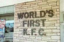
- The world's first Kentucky Fried Chicken (now KFC) franchise was established in 1952 by Harland Sanders and Pete Harman in what is now part of South Salt Lake.[21]
- Zagg, manufacturer and marketer of the popular invisibleSHIELD gadget protection film, is based in South Salt Lake.[22]
References
- 1 2 "American FactFinder". United States Census Bureau. Retrieved 2008-01-31.
- ↑ "US Board on Geographic Names". United States Geological Survey. 2007-10-25. Retrieved 2008-01-31.
- ↑ http://www.southsaltlakecity.com/uploads/documents/2013_July.pdf
- ↑ SSL History, Copyright 1997; Richard Fox, South Salt Lake City; Salt Lake County Records, Abstract of Title no. B-3735 prepared by Western States Title Insurance Company
- ↑ http://www.southsaltlakecity.com/department-listings/history
- ↑ http://www.southsaltlakecity.com/department-listings/mayors-office
- ↑ "Annual Estimates of the Resident Population for Incorporated Places: April 1, 2010 to July 1, 2015". Retrieved July 2, 2016.
- ↑ "Census of Population and Housing". Census.gov. Retrieved June 4, 2015.
- ↑ American Fact Finder
- ↑ "South Salt Lake (city) QuickFacts from the US Census Bureau". quickfacts.census.gov. Retrieved 2015-11-13.
- ↑ Wendy Leonard, "South Salt Lake breaks ground for Utah's first Chinatown", Deseret News, March 21, 2011
- ↑
- ↑ Wendy Leonard and Nkoyo Iyamba, "South Salt Lake breaks ground for Utah's Chinatown", ksl.com, March 21, 2011
- ↑ Heather L. King, "Diverse Asian options surround South Salt Lake's Chinatown", The Salt Lake Tribune, November 6, 2012
- ↑ Palmer, Rebecca (16 Feb 2008). "Bars to dwindle in South Salt Lake Aim is one permit per 3,000 residents: 8 establishments". Deseret News. Salt Lake City: Deseret Digital Media. Retrieved 12 May 2013.
- ↑ "These Are The 10 Most Dangerous Places in Utah". Movoto.com. Retrieved 2015-11-13.
- ↑ "Salt Lake County System Map" (JPG) (Map). rideuta.com. Utah Transit Authority. April 2013. Retrieved 12 May 2013.
- ↑ Vo-Duc, Viviane (5 Sep 2013). "New streetcar S-line set to open Dec. 8 in Sugar House". Deseret News. Salt Lake City: Deseret Digital Media. Retrieved 17 Sep 2013.
- ↑ "State Street Closed At Night Next Two Weekends for Streetcar Construction". Utah Transit Authority. 18 Apr 2013. Retrieved 12 May 2013.
- ↑ "Sugar House Street Car". rideuta.com. Utah Transit Authority. Retrieved 12 May 2013.
- ↑ Henetz, Patty; Nii, Jennifer (21 Apr 2004). "Colonel's landmark KFC is mashed". Deseret Morning News. Salt Lake City: Deseret Digital Media. Associated Press. Retrieved 12 May 2013.
- ↑ "Customer Service". Zagg. Retrieved 12 May 2013.
External links
 |
Glendale neighborhood of Salt Lake City | Peoples Freeway neighborhood of Salt Lake City | Liberty Wells neighborhood of Salt Lake City | |
| West Valley City | |
Sugar House neighborhood of Salt Lake City | ||
| ||||
| | ||||
| Taylorsville | Millcreek | Millcreek |
Municipalities and communities of Salt Lake County, Utah, United States | ||
|---|---|---|
| Cities | 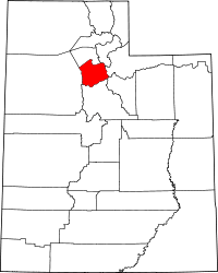 | |
| Town | ||
| Townships | ||
| CDPs | ||
| Unincorporated community | ||
| Ghost towns | ||
| Footnotes | ‡This populated place also has portions in an adjacent county or counties | |