South Mountain Reservation
| South Mountain Reservation | |
|---|---|
|
IUCN category V (protected landscape/seascape) | |
|
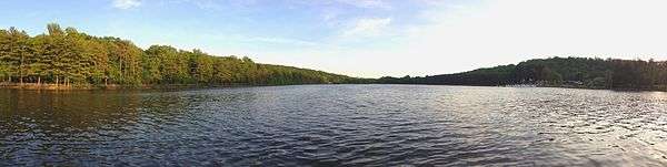
Crater View | |
 | |
| Nearest city | Newark, New Jersey |
| Coordinates | 40°45′00″N 74°17′34″W / 40.75000°N 74.29278°WCoordinates: 40°45′00″N 74°17′34″W / 40.75000°N 74.29278°W |
| Area | 2,047 acres (8 km2) |
| Established | 1895 |
| Governing body | Essex County |
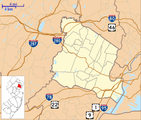
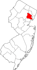
South Mountain Reservation, covering 2,110 acres (8 km2), is a nature reserve on the Rahway River that is part of the Essex County Park System in northeastern New Jersey, United States. It is located in central Essex County, New Jersey, within portions of Maplewood, Millburn and West Orange, and borders South Orange, between the first and second ridges of the Watchung Mountains.[1]
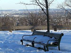
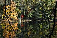
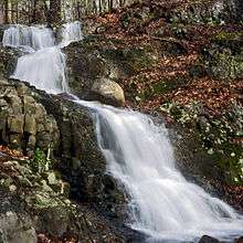
Carved from wilderness at the end of the 19th century, designed by Olmsted Brothers, and developed over a few decades, the reservation has changed only slightly through the years. Preserved primarily in its wild state, woodlands abound in a variety of hardwood trees, and tall hemlocks tower above streams, creeks and ponds, and waterfalls. Higher points, such as Crater View, offer vistas of the New York and Jersey City skylines, Elizabeth, Union Township, and Staten Island.[2]
Recreational Complex
Richard J. Codey Arena and Turtle Back Zoo are located within the reservation's boundaries.[3] The recreation area was expanded to include Safari Minigolf and the Treetop Adventure Ropes Course in 2010, and McCloone's Boathouse Restaurant abutting the Orange Reservoir was added in 2011.[3] In 2013, a paddleboat concession was added, accessible from Cherry Lane, across from the Oakdale Picnic Area, and paths from the restaurant and zoo.[4]
Orange Reservoir
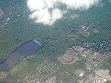
Orange Reservoir is a reservoir located in the reservation's northern tract. Within the borders of West Orange, it is owned by the City of Orange and operated and maintained under contract with United Water. It was originally developed during the intense urbanization of northeastern New Jersey in the late 19th century, drawing from the Rahway River.[5] The man-made lake is no longer part of the water-supply system and since the late 2000s (decade) various proposals have been made to allow its use as a recreational resource as part of the Recreational Complex. The complex abutting the reservoir includes a miniature golf course,[6] and a boathouse-restaurant opened in 2011.[4] Proposals were complicated by the fact that while owned by one municipality, it lies within the borders of another, and it is unclear whether it is taxable.[7] Offers by the Essex County Park System to buy or lease property were put in place as a possible resolution.[8] The county was able to reach an agreement to lease the reservoir from the City of Orange until 2032.[9] In November 2013 it was announced that bridges and other improvements for recreational use would be made.[10][11]
Dam proposal
In response to potential destructive rain events, several proposals for flood mitigation plans include damming the Rahway River, with headwaters in the reservation.[12]
History

Development
In 1860, wolves, bears and cougars were observed in the area, and there was a bounty on them. in 1896, John Durand, the son of Asher Brown Durand, described the mountain that includes South Mountain Reservation
- “a wilderness, as it probably existed at the time of Hendrick Hudson, a primitive forest abounding with deer and other wild animals, and traversed by streams alive with trout. Game was plentiful – partridges, quail, woodcock, rabbits, squirrels of every species, raccoons and foxes; while occasionally a hungry bear that had trespassed on the farmyards in the vicinity would be tracked to its den and shot.”
The reservation was built from land purchases begun in 1895. It took a decade to untangle the deeds and assemble all the lands at South Mountain. Before he delegated design of the Essex Parks to his stepson's firm, Frederick Law Olmsted visited the newly acquired reservation. He regarded it as some of the most beautiful and promising terrain he had ever seen anywhere. The design of South Mountain was finalized by the Olmsted Brothers in stages over the years. A good deal of construction work — trails, footbridges, shelters, etc. — was carried out by the Civilian Conservation Corps in the 1930s.
Revolutionary era
Washington Rock is a Revolutionary War historic site, dating back to the late 18th century when Beacon Signal Station 9 was located here—one of 23 beacons built by General Washington to observe British troop movements quartered on Staten Island and New York City.
It was from this outlook that, on June 23, 1780, Essex County and Newark Militia were first warned that the British had launched an attack westward toward "the Gap," (Hobart Gap), a natural pathway to Washington's troops encamped at Morris Town. In a pincer movement designed to gain access to the Gap, Hessian troops fought bitterly along Vaux Hall Road, while the British advanced along Galloping Hill Road, until they were repelled, the Hessians at the base of the mountain and the British in Springfield.[13]
References
- ↑ South Mountain Reservation, accessed April 7, 2007
- ↑ Kofsky, Jared (26 October 2009). "Walk in the Park: Scenic Reservation Overlooks". www.patch.com. South Orange Patch. Retrieved 17 March 2016.
Located on Crest Drive between Washington Rock and the dog park, Crater View is also about 500 feet above sea level. From Crater View...you can see New York, Newark and Jersey City. You can also see the Bayonne Bridge, and with binoculars, you can see cars traveling over it, as well as the Verrazano Bridge. You can see the Empire State Building, the world’s tallest water tower in Union...
- 1 2 "South Mountain Reservation". Essex County Department of Parks. Retrieved 2011-12-13.
- 1 2 Real, Philip (October 19, 2010), "County executive unveils plan for $4M restaurant near Essex redevelopment sites", The Star-Ledger, retrieved 2011-12-11
- ↑ "The Water Question at Orange", The New York Times, September 24, 1882, retrieved 2011-12-11
- ↑ Read, Philip (January 26, 2010), "Essex to develop miniature golf course along Orange Reservoir", The Star-Ledger, retrieved 2011-12-11
- ↑ Lee, Eunice (December 11, 2011), "Orange Reservoir remains mired in legal disputes over whether it is taxable", The Star-Ledger, retrieved 2011-12-11
- ↑ Khavkine, Richard (March 20, 2011), "Orange rejects Essex County's offer to buy city's reservoir for $700K", The Star-Ledger, retrieved 2011-12-11
- ↑ "Orange Reservoir Walkway and Pedestrian Bridges Installed by The Shauger Group". Patch. 9 May 2014. Retrieved 2 January 2015.
- ↑ http://www.nj.com/essex/index.ssf/2013/11/orange_reservoir_to_get_21m_in_upgrades_that_include_walkway_2_bridges.html#incart_river_default
- ↑ http://essexnewsdaily.com/news/westorange/walking-path-bridges-around-orange-reservoir-complete
- ↑ http://www.nj.com/news/index.ssf/2014/04/south_mountainside_reservation_plan.html#incart_river_default
- ↑ Thomas Fleming, The Forgotten Victory (New York: Reader's Digest Press, distributed by E. P. Dutton & Co., Inc, 1973)
External links
- Hike of the Week at South Mountain Reservation
- South Mountain Conservancy
- Weekly Trail Running in South Mountain Reservation
- Geology of South Mountain Reservation
- NJ.com News Article
- Essex County Parks System
- NY-NJTC: South Mountain Reservation Trail Details and Info
- Photographs
| County parks | 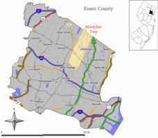 | |
|---|---|---|
| Town parks |
| |
| Reservations |
| |
| Other facilities | ||
| Parks |
|  |
|---|---|---|
| Reservations | ||
| Other facilities |
| |