South Glastonbury Historic District
|
South Glastonbury Historic District | |
|
The South Glastonbury Library, a former church building | |
  | |
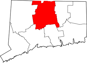
| Location | High, Hopewell, Main and Water Sts., Glastonbury, Connecticut |
|---|---|
| Coordinates | 41°39′59″N 72°36′15″W / 41.66639°N 72.60417°WCoordinates: 41°39′59″N 72°36′15″W / 41.66639°N 72.60417°W |
| Area | 75 acres (30 ha) (1984 size) |
| Architectural style | Greek Revival, Colonial, Queen Anne |
| NRHP Reference # |
84000250[1] (original) 09000343 (increase) |
| Significant dates | |
| Added to NRHP | November 23, 1984 |
| Boundary increase | September 24, 2009 |
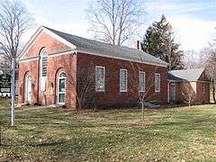
The South Glastonbury Historic District is a historic district in Glastonbury, Connecticut. It encompasses the historic village center of South Glastonbury, which was first settled in the 17th century. High Street is the oldest street in the district; it is part of the original east-west route from the Connecticut River ferry connecting Glastonbury and [Rocky Hill, Connecticut|Rocky Hill]]. The village center is a triangle made up of all or part of Main, High, and Water Streets, and includes 83 contributing resources, including the public library, located in a former Methodist Church built in 1828, a c. 1740 house at 120 High Street, and the c. 1878 Carpenter Gothic St. Augustine's Church.[2]
The district was listed on the National Register of Historic Places in 1984, and enlarged in 2009[1] to include properties further along Main Street as far as Chestnut Hill Road.
See also
References
- 1 2 National Park Service (2009-03-13). "National Register Information System". National Register of Historic Places. National Park Service.
- ↑ "NRHP nomination for South Glastonbury Historic District" (PDF). National Park Service. Retrieved 2014-12-19.
| Topics | |
|---|---|
| Lists by states |
|
| Lists by insular areas | |
| Lists by associated states | |
| Other areas | |
| |