South Dakota Highway 22
| ||||
|---|---|---|---|---|
|
Route of SD 22 (in red) | ||||
| Route information | ||||
| Defined by SDCL §31-4-147 | ||||
| Maintained by SDDOT | ||||
| Length: | 50.548 mi[1] (81.349 km) | |||
| Existed: | 1926 – present | |||
| Major junctions | ||||
| West end: | Hazel | |||
| East end: |
| |||
| Location | ||||
| Counties: | Hamlin, Deuel | |||
| Highway system | ||||
| ||||

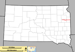
South Dakota Highway 22 is a state route in northeast South Dakota. It begins at the town of Hazel, and terminates at the Minnesota border west of Canby, Minnesota, where it becomes Minnesota State Highway 68. It is about 50.5 miles (81.3 km) in length.
Route description
SD 22 begins at an intersection with an unnumbered highway in the town of Hazel in Hamlin County. It heads about nine miles due east before curving southeast to bypass a lake. Two miles east of the lake, SD 22 turns south to begin a concurrency with US 81. Two miles south of here, SD 22 branches east from US 81 and continues east past Castlewood. The highway curves north for a mile, then turns east and heads for Deuel County. Just east of the county line, SD 22 shares an interchange with Interstate 29.[2]
The highway heads east for ten miles and enters Clear Lake. In Clear Lake, SD 22 intersects SD 15. About eleven miles east of the city, the route intersects the southern terminus of SD 101. After this intersection, SD 22 curves to the south for two miles and then turns to the east and enters Minnesota, becoming Minnesota State Highway 68.[2]
History
When designated in the 1920s, South Dakota 22 ran west to east across the entire width of the state, on what is currently U.S. Highway 212. When U.S. 212 was assigned in 1927, SD 22 was moved south onto a new alignment, beginning at South Dakota Highway 45 near Howell, and ending at what was then South Dakota Highway 41 (current U.S. Highway 281) south of Redfield. This route was truncated in the mid-1930s to the current alignment, although there was a north–south segment between Hazel and U.S. Highway 212. This portion of the segment was deleted in 1992.
Major intersections
| County | Location | mi[1] | km | Destinations | Notes |
|---|---|---|---|---|---|
| Hamlin | Hazel | 0.000 | 0.000 | Begin state maintenance | |
| | 13.492 | 21.713 | West end of US 81 concurrency | ||
| | 15.496 | 24.938 | East end of US 81 concurrency | ||
| Deuel | | 27.264 | 43.877 | I-29 exit 164. | |
| Clear Lake | 37.833 | 60.886 | |||
| | 48.205 | 77.578 | |||
| | 50.548 | 81.349 | Continuation into Minnesota | ||
1.000 mi = 1.609 km; 1.000 km = 0.621 mi
| |||||
References
- 1 2 "State Highway Log" (PDF). Aberdeen region: South Dakota Department of Transportation. January 2011. pp. 78–79. Retrieved December 22, 2011.
- 1 2 "Google Maps Overview of SD 22". Retrieved October 29, 2012.