South Beach Branch
| South Beach Branch | |
|---|---|
|
SIRT Employee Timetable 1921–1922 East Shore and Perth Amboy Sub-Divisions | |
| Overview | |
| Type | Rapid transit |
| System | Staten Island Railway |
| Status | Abandoned |
| Locale | Staten Island, New York, USA |
| Termini |
Clifton Wentworth Avenue |
| Stations | 8 |
| Operation | |
| Opened | March 8, 1886 |
| Closed | March 31, 1953 |
| Owner | Baltimore & Ohio Railroad |
| Operator(s) | Staten Island Railway |
| Technical | |
| Line length | 4.1 miles (6.6 km) |
| Number of tracks | 2 |
| Track gauge | 4 ft 8 1⁄2 in (1,435 mm) |
| Electrification | 1925 |

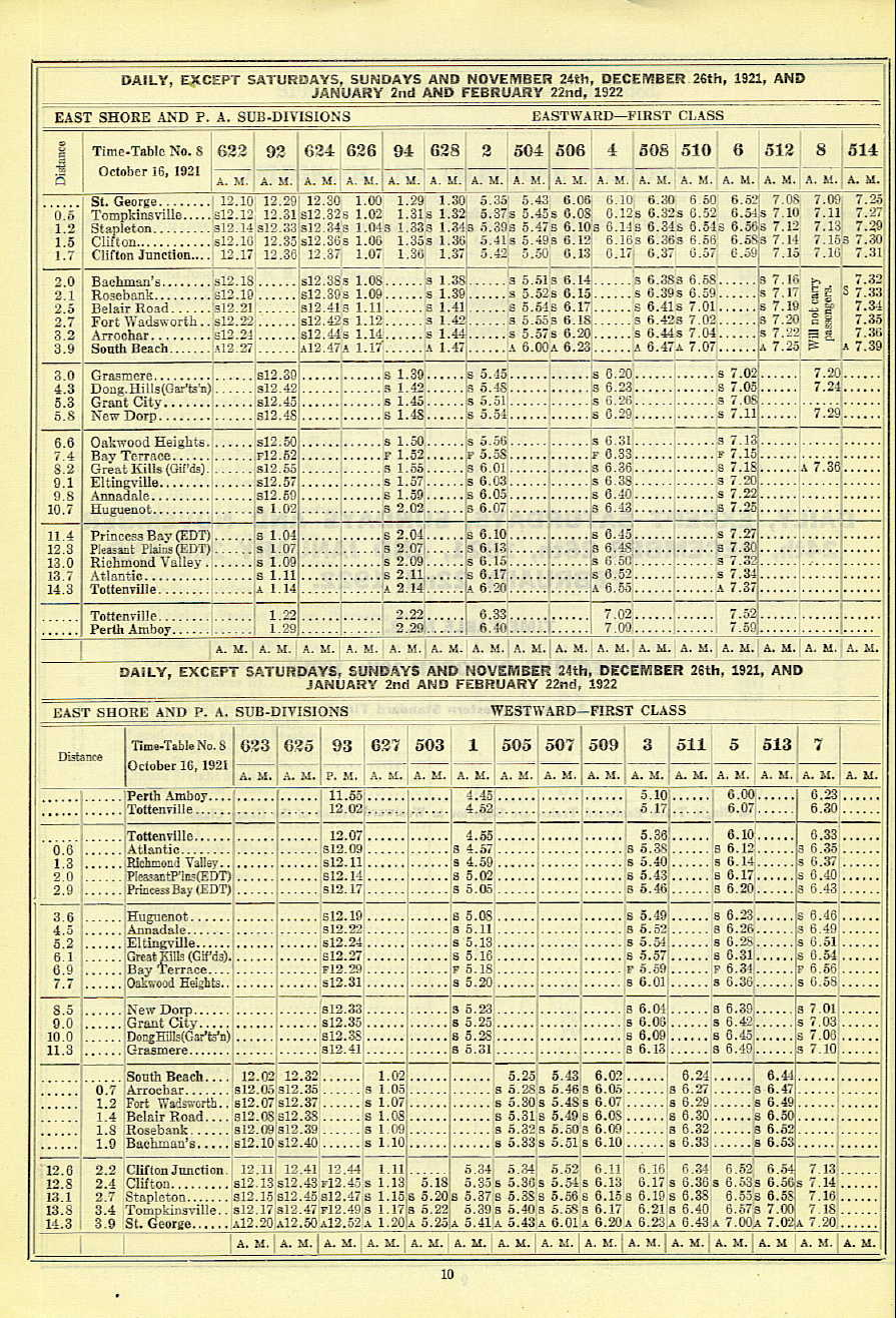
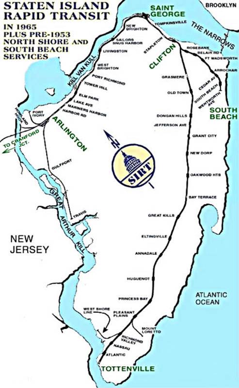
The South Beach Branch, also called the East Shore Sub-Division,[1] is an abandoned branch of the Staten Island Railway in New York City, which operated along Staten Island's East Shore from Clifton to Wentworth Avenue. This 4.1-mile (6.6 km) double-tracked branch left the Main Line at 40°37′08″N 74°04′18″W / 40.61889°N 74.07167°W, south of the Clifton station, and lay to the east of the Main Line.
Rapid transit service on the line ended on March 31, 1953, along with the North Shore Branch.
History
The East Shore branch opened on March 8, 1886 to Arrochar, and was extended to South Beach sometime after September 1888, when it was proposed to extend the line.[2] Trains on the branch typically consisted of one or two cars.[3]
In 1925, the branch was extended one stop to Wentworth Avenue, with a platform just long enough to accommodate one door of a single car.[3]
The first electric train was operated on the South Beach Branch between South Beach and Fort Wadsworth at 9:45 P. M. on May 30, 1925. This sub-division was put into regular operation at 12:01 A.M. June 5, 1925.[4]
In 1936–1937, the branch was elevated to remove several grade crossings.[3][5]
The New York City Board of Transportation gained almost complete control of the island’s bus lines in 1948 and cut fares to match the other city lines. The railroad could not match the fare cut and lost 60% of its business almost immediately. The railroad announced plans to terminate all passenger operations in 1953 but a threat from the city to relieve them of their still-profitable freight service along with a commitment for a sizeable city subsidy preserved the Main Line to Tottenville. The short South Beach and North Shore branches were agreed to be no longer viable and passenger service was terminated on both lines March 31, 1953.[6] The South Beach branch was abandoned shortly thereafter while the North Shore Branch continued to carry freight.[7][8][9] On both lines, the third rail was removed by 1955.[10]
The fares on the branch were collected by the conductor on the train, who had to pull a cord, similar to how it was done with trolleys. The Baltimore & Ohio Railroad, which owned the branch and eventually wanted to abandon the unprofitable service, purposely looked the other way when conductors skimmed something off the top. This allowed B&O to show a lower ridership to the Interstate Commerce Commission, thereby encouraging the abandonment of the branch.[11]

The South Beach Branch was abandoned and demolished except for three segments: a concrete embankment on Saint John's Avenue, a trestle spanning Robin Road in Arrochar, and a filled-in bridge which McClean Avenue crosses over.[3][7]
The original South Beach right-of-way stood in place well into the 1990s, and the former right-of-way is still traceable on maps. Today, houses stand on most of the line, and some of it was demolished in the early 1960s to make way for the Verrazano Bridge toll plaza. While that was being built, the Lily Pond Avenue overpass was built to align perfectly with the old railroad right-of-way, just in case the line was ever to be reactivated.[7]
The Robin Road Trestle is the only remaining intact trestle along the former line. In the early 2000s, developers purchased the property on either side of the trestle's abutments, but the developers, the New York City Department of Transportation, and the New York City Transit Authority all claimed ownership of it. Consequently, townhouses have built up against both sides of it.[3][5][12][13]
Railroad Avenue still exists alongside the line's right-of-way. In addition, the street grid is interrupted by the line's old right-of-way, and a few supporting structures still exist.[5]
Station list
| Miles | Name | Opened | Closed | Notes |
|---|---|---|---|---|
| 2.0 | Bachmann | March 8, 1886 | 1937 | Also called Bachmann's |
| 2.1 | Rosebank | March 8, 1886 | March 31, 1953[9] | |
| 2.5 | Belair Road | March 8, 1886 | March 31, 1953[9] | |
| 2.7 | Fort Wadsworth | March 8, 1886 | March 31, 1953[9] | |
| 3.2 | Arrochar | March 8, 1886 | March 31, 1953[9] | |
| 3.5 | Cedar Avenue | 1934 | March 31, 1953[9] | |
| 3.9 | South Beach | 1889 | March 31, 1953[9] | |
| 4.1 | Wentworth Avenue | 1925 | March 31, 1953[9] |
References
- ↑ Staten Island Rapid Transit 1921 Time Table
- ↑ "Staten Island Improvement". The New York Times. September 1, 1888. Retrieved July 3, 2015.
- 1 2 3 4 5 "Gary Owen's SIRT South Beach Line Page, Part Two".
- ↑ Official Proceedings of the New York Railroad Club, Volume 36. 1925.
- 1 2 3 "Staten Island Railway". Forgotten New York. 2012.
- ↑ Minn, Michael (2009). "History and Future of the North Shore Rail Line on Staten Island" (PDF).
- 1 2 3 "Gary Owen's SIRT South Beach Line Page".
- ↑ Drury, George H. (1985). The Historical Guide to North American Railroads: Histories, Figures, and Features of more than 160 Railroads Abandoned or Merged since 1930. Waukesha, Wisconsin: Kalmbach Publishing. pp. 312–314. ISBN 0-89024-072-8.
- 1 2 3 4 5 6 7 8 "Passenger Runs on Two Lines of SIRT Will End at Midnight". Staten Island Advance. March 31, 1953. Retrieved October 14, 2015.
- ↑ Pitanza, Marc (2015). Staten Island Rapid Transit Images of Rail. Arcadia Pubishing. ISBN 978-1-4671-2338-9.
- ↑ Henderson, John (1992). Gotham Turnstiles: A Visual Depiction of Rapid Transit in the New York Metropolitan Area from 1958–1968. H&M Productions. ISBN 9780962903786. Retrieved November 23, 2015.
- ↑ "Arrochar and South Beach: In the Shadow of the 'Zano". Forgotten New York. 2009.
- ↑ "Permission to dream". Staten Island Advance. December 7, 2008. Retrieved October 8, 2015.
| Lines |  | ||||||||||
|---|---|---|---|---|---|---|---|---|---|---|---|
| Stations |
| ||||||||||
| Infrastructure |
| ||||||||||
| Rolling Stock | |||||||||||
| Other | |||||||||||