South East Queensland
| South East Queensland Queensland | |||||||||||||
|---|---|---|---|---|---|---|---|---|---|---|---|---|---|
 Regions of Queensland with South East Queensland marked as Brisbane and Moreton | |||||||||||||
| Population | 3,400,000 (2014)[1] | ||||||||||||
| • Density | 151.7/km2 (393/sq mi) | ||||||||||||
| Established | 1824 | ||||||||||||
| Area | 22,420 km2 (8,656.4 sq mi) | ||||||||||||
| LGA(s) | City of Brisbane, Somerset Region, Sunshine Coast Region, Moreton Bay Region, Redland City, Logan City, Shire of Noosa, City of Gold Coast, Scenic Rim Region, City of Ipswich, Lockyer Valley Region | ||||||||||||
| |||||||||||||
South East Queensland (SEQ) is a bio-geographical, political, and administrative region of the state of Queensland in Australia, which contains 3.4 million people out of the state's population of 4.8 million.[1] The area covered by South East Queensland varies, depending on the definition of the region. Its most common use is for political purposes, and covers 22,420 square kilometres (8,660 sq mi) and incorporates 11 local government areas, extending 240 kilometres (150 mi) from Noosa in the north to the Gold Coast and New South Wales border in the south (some sources include Tweed Heads (NSW) which is contiguous as an urban area with Brisbane/Gold Coast), and 140 kilometres (87 mi) west to Toowoomba (which is simultaneously considered part of the Darling Downs region).
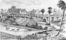
South East Queensland was the first part of Queensland to be settled and explored by Europeans. Settlements initially arose in the Brisbane and Ipswich areas with activity by European immigrants spreading in all directions from there. Various industries such as timber cutting and agriculture quickly developed at locations around the region from the 1840s onwards. Transport links have been shaped by the range of terrains found in South East Queensland.
The economy of South East Queensland supports and relies on a wide diversity of agricultural manufacturing industries, commerce and tourism. The region has an integrated public transport system, TransLink.
Definitions
South East Queensland, classified as an interim Australian bioregion, comprises 7,804,921 hectares (19,286,380 acres) and includes the Moreton Basin, South Burnett, and the Scenic Rim along with ten other biogeographic subregions.[2] The term South East Queensland has no equivalent political representation. The area covers many lower house seats at the federal and state levels. As Queensland has no upper house, there are no Legislative Council provinces or regions to bear the name either.
History
South East Queensland was home to around 20,000 Aboriginals prior to British occupation. The local tribes of the area were the Yuggurapul of the Central Brisbane area; the Yugumbeh people whose traditional lands ranged from South of the Logan River, down to the Tweed River and west to the McPherson Ranges; the Quandamooka people whose traditional lands encompassed the Moreton Bay Islands to the mouth of the Brisbane River to Tingalpa and south to the Logan River; and the Gubbi Gubbi people whose traditional lands were known to exist north of the Pine River, to Burrum River in the north, and west to the Conondale ranges. According to history researchers the Aboriginal population declined to around 10,000 over the next 60 years.[3]
Early explorers in the area including Matthew Flinders, Allan Cunningham, John Oxley and Patrick Logan. Around 1839, European settlers were able to move into the region. Logging was the first industry to develop. The first railway built in Queensland linked Grandchester to Ipswich in 1865 along a narrow 1067 mm gauge.[4]
Major floods were experienced in 1893, 1974 and 2011. In 2005, the region suffered its worst drought in recorded history.[5]
Geography
Queensland's third highest peak, Mount Barney, is located in the south of the region. The Cunningham Highway passes southwest to the Darling Downs via Cunninghams Gap. Several highways including the Bruce Highway, Warrego Highway and the Pacific Motorway link to the adjoining regions.

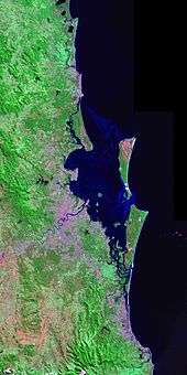
The region is mountainous. McPherson Range, Teviot Range, D'Aguilar Range, Little Liverpool Range, Blackall Range as well as the Springbrook Plateau and Tamborine Mountain Plateau. Isolated volcanic peaks are found at Moogerah Peaks and the Glass House Mountains. Along the coast are several large islands including Bribie Island, Moreton Island and North Stradbroke Island with many smaller islands in Moreton Bay. Several major water supply and flood mitigation dams have been constructed here. The Western Corridor Recycled Water Scheme and Gold Coast Desalination Plant were recently built to counter the effects of drought in South East Queensland.
Regions and local government areas
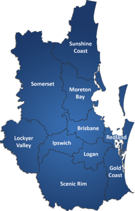
South East Queensland generally consists of the following regions, each of which is also a local government area (LGA):
- Brisbane - the capital and largest city of Queensland. The Brisbane metropolitan area consists of the City of Brisbane, as well as the following local governments:
- Ipswich City - an outer-suburban city with an industrial and mining heritage west of Brisbane.
- Logan City - a largely residential area between Brisbane and the Gold Coast.
- Moreton Bay Region - a largely residential area between Brisbane and the Sunshine Coast.
- Redland City - a residential and agricultural area on the shores of Moreton Bay to the south-east of Brisbane.
- City of Gold Coast - a major tourist and retirement destination to the south of Brisbane, and the largest non-capital city in Australia.
- Sunshine Coast Region - a coastal tourist and agricultural region to the north of Brisbane. The Glass House Mountains are a symbol of this region.
- West Moreton, a rural area in the Great Dividing Range consisting of:
- Toowoomba City - the Toowoomba city is included in both the South East Queensland region and within Western Downs (although the full Toowoomba region is only in western downs) region due to its importance to both regions as a gateway city providing access to the west of the state.
- Lockyer Valley Region - an agricultural area west of Ipswich, known for its fruit and vegetable production.
- Scenic Rim Region - a pastoral area inland from the Gold Coast known for its scenic mountains and villages.
- Somerset Region - a pastoral area north west of Brisbane and location of two major dams supplying South East Queensland with water. This area is also known as the Brisbane Valley.
The Tweed Shire is actually within NSW but is often included in planning processes for SEQ. While not officially part of the TransLink public transport network, Surfside Buses run a seamless service across the border that appears to passengers as though it is integrated.
A highly effective integrated ticketing system for public transport has averted transport gridlock in the region.[6]
Major cities
The region is a complex, regional hybrid linking Brisbane with several surrounding cities.[6] South East Queensland includes the following regional cities:
- Brisbane, Queensland's capital and largest city
- Gold Coast, Queensland's premier tourist destination and surfing mecca to the south of Brisbane.
- Sunshine Coast, another major tourist area to the north of Brisbane.
- Toowoomba, nicknamed 'The Garden City', the most populous inland city in the country after the national capital, Canberra.
- Ipswich, Queensland's oldest provincial city and industrial centre to Brisbane's south-west.
- Logan, a city between Brisbane and the Gold Coast, mostly residential with some light industry.
- The Redlands, a residential and agricultural bushland/coastal area south-east of Brisbane.
- Redcliffe, a seaside urban area between Brisbane and the Sunshine Coast.
New urban centres are currently being develop at Springfield, Ecco Ripley, Yarrabilba and Flagstone. Some geographers suggest several more master-planned communities will be needed to cater for the expected population growth rates.[7]
Airports
- Brisbane Airport - The major international gateway to the region offering services direct to California, Asia, Oceania and the Middle East.
- Gold Coast Airport - The second major gateway is one of Australia's fastest growing airport offering services to Japan, Malaysia, New Zealand and Singapore.
- Sunshine Coast Airport - A domestic airport offering services to Sydney and Melbourne.
- Brisbane West Wellcamp Airport - The first privately funded major airport in the country. Services the Toowoomba and surrounding Darling Downs region, with a view to becoming a major international freight hub.
- Archerfield Airport - a general aviation airport located approximately 11 km south of the Brisbane CBD.
- Redcliffe Airport - a general aviation airport located on the Redcliffe Peninsula approximately 28 km from the Brisbane CBD.
- RAAF Base Amberley - the largest operational base of the air force in Australia located in south-western Ipswich approximately 50 km from the Brisbane CBD.
Industry
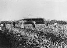
The region exports a number of crop products including broccoli, onion, Chinese cabbage, sweet corn and celery.[8] A sizable vegetable industry is established in the Lockyer Valley. Timber cutting, mining and a range of agricultural pursuits including dairying were once prominent in South East Queensland. Tourism, in part due to Brisbane serving as major transport and export hub and destinations such as the Gold Coast and the availability of land for industry, has grown in recent decades together with specialised skills in professional services and manufacturing.[9]
Demographics
As of 2014 the population of South East Queensland is estimated to be approximately 3.4 million, meaning that between one in six and one in seven Australians call the region home.[1] The regional population is heavily urbanised and concentrated along the coast. The three largest population centres of Brisbane, Gold Coast and the Sunshine Coast account for 90 per cent of the region's population.[10]
Immigration and population growth
South East Queensland is one of the fastest growing regions in Australia. Growth in the state is fueled principally by migration from the southern states and overseas.[11] In 2010, South East Queensland's population grew by an average of about 1,200 new residents each week.[12]
The region has experienced significant population growth over the last two decades, growing on average by 55,000 to 80,000 people a year since 1986. South East Queensland is expected to be home to 4.4 million by 2031.[13] A 2010 report concluded that the region will reach 5.5 million people by 2051.[14]
Regional planning
South East Queensland's future development will be heavily based on the South East Queensland Regional Plan, released by the Queensland state government in 2005.[15] The regional plan covers the period from 2009–2031 and focuses on slowing development along the coast, in order to prevent creating a 200 km city, and instead aim for growth in the west, in particular around Springfield and Beaudesert.[15] Infrastructure planning in South East Queensland is almost exclusively designed to facilitate trans-metropolitan travel and reduce traffic congestion.[6]
Environment
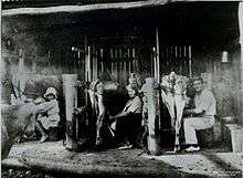
.jpg)
Predominantly rural landscapes lie to the west of the urbanised coastal centres. The Lockyer Valley, a major agricultural area referred to as "South East Queensland's Salad Bowl", lies outside Brisbane. Many World Heritage listed rainforests are located along the region's southern border ranges, an area known as the Scenic Rim, such as Lamington National Park and Main Range National Park.
Within the region, the koala is listed as vulnerable. The Australian Koala Foundation says the animal is threatened by mining and land development.[16] Numbers in Redland City have seen a dramatic decline in recent years.[17] The state government launched the Koala Conservation Plan in 2006. The plan involved the rehabilitation of cleared areas, domestic dogs containment and koala signage.[17] Another initiative was launched in 2010 to protect and rehabilitate koala habitats by tree planting and the construction of koala friendly fencing.[18]
After many years of water restrictions due to severe drought, the Government of Queensland lifted restrictions across the whole of South East Queensland on 1 January 2013.[19]
See also
- Daylight Saving for South East Queensland
- Rail network in South East Queensland
- Shopping Centres in South East Queensland
- The 200 Kilometre City
References
- 1 2 3 "3218.0 - Regional Population Growth, Australia, 2013-14". Australian Bureau of Statistics. ERP at 30 June 2014.
- ↑ "Australia's bioregions (IBRA)". Department of Sustainability, Environment, Water, Population and Communities. Commonwealth of Australia. 2012. Retrieved 13 January 2013.
- ↑ Tony Moore (19 May 2012). "Joh-era politics? Not yet, says Aboriginal historian". Brisbane Times. Fairfax Media. Retrieved 19 May 2012.
- ↑ "History of Rail in Australia". Department of Infrastructure and Transport. Retrieved 19 May 2012.
- ↑ "Construction of our projects". WaterSecure. Retrieved 19 May 2012.
- 1 2 3 Gleeson, Brian; Wendy Steele (2010). A climate for growth. St Lucia, Queensland: University of Queensland Press. p. 8. ISBN 9780702237768. Retrieved 23 October 2013.
- ↑ Tony Moore (27 June 2015). "SEQ population growth needs 12 Springfield-style mega cities to cope: planner". Brisbane Times. Fairfax Media. Retrieved 27 June 2015.
- ↑ "Vegetable production in South East Queensland". Department of Agriculture, Fisheries and Forestry. 15 April 2014. Retrieved 4 November 2014.
- ↑ "Business advantages in South East Queensland". The State of Queensland. Retrieved 24 June 2015.
- ↑ South East Queensland Regional Plan - Part B: Growth management. URL accessed on 21 January 2007.
- ↑ Peter Hutson, Mark Saunders, Phillip Kohn & John Merrick (13 February 2008). "Human settlements: Population and settlement patterns". Department of Environment and Resource Management. Retrieved 31 March 2012.
- ↑ "Population growth highlights and trends Queensland 2011" (PDF). Queensland Treasury. September 2011. Retrieved 31 March 2012.
- ↑ South East Queensland - Department of Infrastructure and Planning
- ↑ Marissa Calligeros (25 March 2010). "'Fortress Queensland': population cap blasted". Brisbane Times. Fairfax Media. Retrieved 31 March 2012.
- 1 2 (7 December 2011). South East Queensland Regional Plan. Department of Local Government and Planning. Retrieved on 31 March 2012.
- ↑ Darren Cartwright (11 March 2012). "Activists can't bear Newman's koala protection plan". Sydney Morning Herald. Fairfax Media. Retrieved 31 March 2012.
- 1 2 Nadine McGrath (9 September 2007). "Koalas 'in crisis' in South East QLD". Brisbane Times. Retrieved 31 March 2012.
- ↑ Tom Forbes & Nicole Jacobi (25 February 2010). "Koala habitat plan seen as good start". ABC News. Australian Broadcasting Corporation. Retrieved 31 March 2012.
- ↑ "No water restrictions as Wivenhoe runs at high capacity". Brisbane Times. Fairfax Media. 1 September 2013. Retrieved 1 September 2013.
External links
| Wikimedia Commons has media related to South East Queensland. |
- South East Queensland Wikibook
- SEQ History South East Queensland History
- South East Queensland Council of Mayors.
| Topics | ||
|---|---|---|
| Regions | ||
| Cities and towns | ||
| ||