Somerville, Alabama
| Somerville, Alabama | |
|---|---|
| Town | |
|
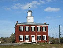
The Somerville Courthouse was built in 1837 in the Federal style. It served as the county courthouse for Morgan County until the county seat was moved from Somerville to Decatur in 1891. It was listed on the National Register of Historic Places on March 24, 1972. | |
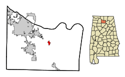 Location in Morgan County and the state of Alabama | |
| Coordinates: 34°28′12″N 86°47′56″W / 34.47000°N 86.79889°W | |
| Country | United States |
| State | Alabama |
| County | Morgan |
| Area | |
| • Total | 1 sq mi (2.6 km2) |
| • Land | 1 sq mi (2.6 km2) |
| • Water | 0 sq mi (0 km2) |
| Elevation | 656 ft (200 m) |
| Population (2010) | |
| • Total | 347 |
| • Density | 724/sq mi (133.5/km2) |
| Time zone | Central (CST) (UTC-6) |
| • Summer (DST) | CDT (UTC-5) |
| ZIP code | 35670 |
| Area code(s) | 256 |
| FIPS code | 01-71496 |
| GNIS feature ID | 0127103 |
Somerville is a town in Morgan County, Alabama, United States. It is included in the Decatur Metropolitan Area, as well as the Huntsville-Decatur Combined Statistical Area. As of the 2010 census, the population of the town was 724, up from 347.
Somerville was the county seat of Morgan County from 1818 to 1891, when the seat was moved to Decatur. The town was named for Robert M. Summerville, an officer killed in 1814 during the Creek Indian War. Initially incorporated on December 3, 1819,[1] it is a few days older than the state. After its loss of the county seat in the 1890s, its incorporation lapsed. It was reorganized (reincorporated) on December 1, 1955.[2]
Geography
Somerville is located at 34°28′12″N 86°47′56″W / 34.47000°N 86.79889°W (34.469961, -86.798782).[3]
According to the U.S. Census Bureau, the town has a total area of 1.0 square mile (2.6 km2), all land.
Demographics
| Historical population | |||
|---|---|---|---|
| Census | Pop. | %± | |
| 1850 | 217 | — | |
| 1870 | 115 | — | |
| 1880 | 209 | 81.7% | |
| 1960 | 166 | — | |
| 1970 | 185 | 11.4% | |
| 1980 | 140 | −24.3% | |
| 1990 | 211 | 50.7% | |
| 2000 | 347 | 64.5% | |
| 2010 | 724 | 108.6% | |
| Est. 2015 | 716 | [4] | −1.1% |
| U.S. Decennial Census[5] 2013 Estimate[6] | |||
As of the census[7] of 2000, there were 347 people, 148 households, and 97 families residing in the town. The population density was 339.9 people per square mile (131.4/km²). There were 160 housing units at an average density of 156.7 per square mile (60.6/km²). The racial makeup of the town was 91.35% White, 5.76% Black or African American, 1.73% Native American, 0.29% from other races, and 0.86% from two or more races. 0.58% of the population were Hispanic or Latino of any race.
There were 148 households out of which 28.4% had children under the age of 18 living with them, 51.4% were married couples living together, 11.5% had a female householder with no husband present, and 33.8% were non-families. 29.7% of all households were made up of individuals and 8.8% had someone living alone who was 65 years of age or older. The average household size was 2.34 and the average family size was 2.92.
In the town the population was spread out with 22.5% under the age of 18, 11.2% from 18 to 24, 33.1% from 25 to 44, 22.5% from 45 to 64, and 10.7% who were 65 years of age or older. The median age was 36 years. For every 100 females there were 94.9 males. For every 100 females age 18 and over, there were 103.8 males.
The median income for a household in the town was $26,250, and the median income for a family was $31,250. Males had a median income of $29,107 versus $18,958 for females. The per capita income for the town was $13,747. About 13.3% of families and 13.7% of the population were below the poverty line, including 11.0% of those under age 18 and 32.1% of those age 65 or over.
Mayor and City Council
Current Mayor: Darren Tucker
Current Council Members: Sheena Dugger, Carl Flemons, Ron Jones. Michael Rea, and Jackie Teague
Notable people
- Josiah Patterson, U.S. Representative from 1891 to 1897
- Malcolm R. Patterson, Governor of Tennessee from 1907 to 1911
- Joseph Humphrey Sloss, U.S. Representative from 1871 to 1875
- Gary Winton, former basketball player for the United States Military Academy
- Ryan Williams, theoretical computer scientist
References
- ↑ http://www.encyclopediaofalabama.org/article/h-3507
- ↑ http://alabamayesterdays.blogspot.com/2014/10/somervilles-historic-courthouse.html
- ↑ "US Gazetteer files: 2010, 2000, and 1990". United States Census Bureau. 2011-02-12. Retrieved 2011-04-23.
- ↑ "Annual Estimates of the Resident Population for Incorporated Places: April 1, 2010 to July 1, 2015". Retrieved July 2, 2016.
- ↑ "U.S. Decennial Census". Census.gov. Retrieved June 6, 2013.
- ↑ "Annual Estimates of the Resident Population: April 1, 2010 to July 1, 2013". Retrieved June 3, 2014.
- ↑ "American FactFinder". United States Census Bureau. Retrieved 2008-01-31.
http://www.townofsomerville.org/
Coordinates: 34°28′12″N 86°47′56″W / 34.469961°N 86.798782°W
Municipalities and communities of Morgan County, Alabama, United States | ||
|---|---|---|
| Cities | 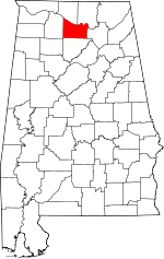 | |
| Towns | ||
| Unincorporated communities | ||
| Ghost town | ||
| Footnotes | ‡This populated place also has portions in an adjacent county or counties | |