Somerset East
| Somerset East Somerset-Oos | |
|---|---|
|
Dutch Reformed Church, Charles Street, Somerset East | |
 Somerset East  Somerset East  Somerset East
| |
| Coordinates: 32°43′S 25°35′E / 32.717°S 25.583°ECoordinates: 32°43′S 25°35′E / 32.717°S 25.583°E | |
| Country | South Africa |
| Province | Eastern Cape |
| District | Sarah Baartman |
| Municipality | Blue Crane Route |
| Established | 1825[1] |
| Area[2] | |
| • Total | 72.8 km2 (28.1 sq mi) |
| Elevation | 750 m (2,460 ft) |
| Population (2011)[2] | |
| • Total | 18,825 |
| • Density | 260/km2 (670/sq mi) |
| Racial makeup (2011)[2] | |
| • Black African | 59.8% |
| • Coloured | 32.2% |
| • Indian/Asian | 0.4% |
| • White | 7.2% |
| • Other | 0.5% |
| First languages (2011)[2] | |
| • Xhosa | 51.8% |
| • Afrikaans | 42.9% |
| • English | 3.7% |
| • Other | 1.6% |
| Postal code (street) | 5850 |
| PO box | 5850 |
Somerset East (Afrikaans: Somerset-Oos) is a town in the Blue Crane Route Local Municipality in the Eastern Cape, South Africa. It was founded by Lord Charles Somerset in 1825.
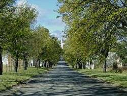
The Blue Crane Route follows the national road R63 from Pearston, via Somerset East, to Cookhouse. Somerset East, at the foot of the Boschberg Mountains, is a quaint, serene little town that's as famous for the natural beauty as it is for its many beautiful provincial heritage sites, all of them buildings.
The forested, mountainous backdrop creates a dramatic setting for the town (which is within sight of no less than 16 waterfalls). This is where you'll find the thickly wooded Boschberg Nature Reserve, with its popular hiking trails - including a 15 km circular route to an overnight hut at the summit of the mountain. As the Route's name suggest, Somerset East is an excellent bird-watching destination - other outdoor adventures include trout fishing on five local dams, as well as rainbow and brown trout fishing in the Glen Avon Waterfall pools, malaria free safari and hunting operations. The highly rated 9-hole golf course is said to be one of the most beautiful in the country.
Amongst the many noteworthy buildings in the town are the Old Wesleyan Chapel, which now houses the Somerset East Museum, and the officers' mess, which now houses the largest collection of paintings by the renowned South African artist Walter Battiss.
Annual events include the Biltong Festival, which was started in 1991, the Bruintjieshoogte Marathon, Bruintjieshoogte Cycle Tour (run between Pearston & Somerset East) and the Spring Rose & Flower show - Somerset East is known to produce some of the finest roses in the country.
History
The first settler in this area was Willem Prinsloo. He settled under the Boschberg, very close to where the Museum is today. Prinsloo was the unofficial field cornet of the district where at least 20 other families had settled by 1774. They send a petition to Cape Town asking for the establishment of a Drostdy and a church in the area, which led to the establishment of Graaff-Reinet.
At some stage Prinsloo gave up parts of his farm and a farmer named Jakobus Cornelius Ismael Safanya Otto moved into the corner now known as Bestershoek. He was followed by the Trichardt and Bester families.
Lord Charles Somerset, taking up the ideas promulgated by Cradock and Caledon that there should be a settlement on the Eastern Frontier, initiated a plan for an experimental farm in the area. American botanist, dr. Mackrill, was given orders to find a suitable farm, and was told to look at three places, the Gamtoos Valley, the Swartkops Valley and Boschberg. He chose the latter.
The farm was established in 1815, for the purpose of improving stockbreeding in the Cape Colony and providing produce for the soldiers at the Frontier. It was named "Somerset Farm".
In 1825 the project was cancelled, a new Drostdy was declared, and the town of Somerset was established. The "East" was only added on 30 years later.
Educational institutions
Gill College is one of the oldest colleges in the Eastern Cape, founded in 1869, after a generous donation from Dr. William Gill.
Aeroville School is a secondary school for grades 8 to 12, on the edge of Somerset East. It is twinned with Golden Hillock School in Birmingham, UK.
Provincial Hospital
Somerset East has a medium-sized government-funded hospital, the Andries Vosloo Hospital.
Coat of arms
Somerset East established a municipality in 1884. By 1931, the town council had assumed a coat of arms.
The shield was divided horizontally. The upper half depicted a bushbuck on a golden background. The lower half was divided vertically, depicting a swallow on a red background and a sunflower on a black background. The swallow was taken from the arms of Gill College and the sunflower from the badge of a local school.[3]
The crest was a phoenix issuing from a golden crown, the supporters were a goat and a ram, and the motto was Foy pour devoir.
References
- ↑ "Chronological order of town establishment in South Africa based on Floyd (1960:20-26)" (PDF). pp. xlv–lii.
- 1 2 3 4 Sum of the Main Places Somerset East and KwaNojoli from Census 2011.
- ↑ 'J.P.' 'Onze gemeentewapens' in NUZA (August 1971).
External links
| Wikimedia Commons has media related to Somerset East. |
- Official Somerset East Information Guide Information
- Tourism information site for Somerset East Information
- Gill College Information
- Timothy Training Institute Information
Municipalities and communities of Sarah Baartman District Municipality, Eastern Cape | ||
|---|---|---|
District seat: Port Elizabeth | ||
| Blue Crane Route | .svg.png) | |
| Dr Beyers Naudé | ||
| Kouga | ||
| Kou-Kamma | ||
| Makana | ||
| Ndlambe | ||
| Sunday's River Valley | ||