Sokol (Lusatian Mountains)
| Sokol | |
|---|---|
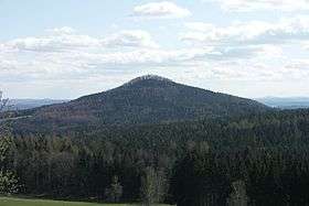 Sokol (Falkenberg) seen from Lückendorf | |
| Highest point | |
| Elevation | 592.5 m (1,944 ft) |
| Coordinates | 50°48′24.5″N 14°45′0″E / 50.806806°N 14.75000°ECoordinates: 50°48′24.5″N 14°45′0″E / 50.806806°N 14.75000°E |
| Geography | |
| Location | Czech Republic |
| Parent range | Lusatian Mountains |
Sokol (German Falkenberg) is a cone-shaped peak in the Lusatian Mountains, just south of the frontier between Germany and the Czech Republic. There are traces at the summit of a medieval castle—Starý Falkenburk (Alte Falkenburg).
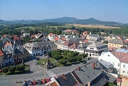
View northwards from Jablonné v Podještědí; Sokol is the peak furthest to the right.
References
Kühn, Jiří (2010). "Sokol - Starý Falkenburk" (in German). Retrieved 2011-06-23.
This article is issued from Wikipedia - version of the 2/28/2013. The text is available under the Creative Commons Attribution/Share Alike but additional terms may apply for the media files.