Sokho
.jpg)
Sokho, alternate spellings: Sokhoh, Sochoh, Soco, Sokoh, Hebrew: שוכה ,שוכו ,שכה, is the name given to two ancient towns in the territorial domain of Judah, both now in ruin.
Both towns were given the name Shuweikah in its Arabic form, although the town that lay to the south of Hebron has been identified with the twin ruins known as Khirbet Shuwaikah Fauka and Tahta (Upper and Lower Shuwaikah), 6 km southwest of Eshtamoa in the Hebron hill district (Joshua 15:48). The other ruin is the more popular of the two, situated on a hilltop overlooking the Elah Valley between Adullam and Azekah (Joshua 15:35). A third town by this name (Sokho = Ar. a-Shuweikeh) was located in the Hefer region (1 Kings 4:10), north of Tulkarm.[1]
History
Although listed in Joshua 15:35 as being a city in the plain, it is actually partly in the hill country, partly in the plain. The Philistines encamped between Sokho and Azekah in the Elah Valley before Goliath's historic encounter with David, the son of Jesse (1 Samuel 17:1). David slew the Philistine giant with a stone slung from a shepherd's sling. Rehoboam fortified the place (2 Chronicles 11:7). It was one of the cities occupied temporarily by the Philistines in the time of Ahaz (2 Chronicles 28:18).
The word "Sokho" appears on certain LMLK seals during the Judean monarchy, believed by many scholars to be one of four cities that acted in some administrative capacity.
The Mishnaic Rabbi Antigonus of Sokho, mentioned in Ethics of the Fathers (Pirkei Avot 1:3), likely came from the Hebron-region town. Rabbi Levi Sukia, of the first generation of Amoraim, also came from Sokho (Jerusalem Talmud, Eruvim).
In Byzantine times, Eusebius described Sokho (Σοκχωθ) as a double village at the ninth milestone between Eleutheropolis (Bet Guvrin) and Jerusalem (Eusebius, Onom. 156:18 ff.), which would correspond to the Elah Valley location. The Madaba Map also depicts Sokho (Σωκω).
Givat HaTurmusim
_-_2_Feb._2015.JPG)
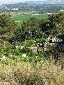
The hill of Tel Sokho is now known as "Givat HaTurmosim," or "Hill of the Lupines." In late March, the entire hill is covered with wild blue Mountain lupines (Lupinus pilosus) and becomes a popular outing destination for Israeli families. [2] The hill is surrounded by precipitous slopes on its north side, making it almost impassable. Trails ascend the mountain on its northwestern side and southeastern sides. The Elah Valley runs in a westerly-easterly direction on its north side, the hilltop affording a good view of the valley below. On the elevated plateau, one can see the foundations of ancient dwellings carved into the bedrock with individual chambers divided by broken stone protuberances. Caves and grottos dot the landscape, and cisterns are carved deep into the rock. Oak trees, fig trees and terebinths grow on the mountainside and piles of large ashlar boulders, covered with lichen, attest to the presence of a defensive wall around the city in antiquity. According to the biblical narrative, when Joshua captured the city from the Canaanites, the city and environs became the inheritance of Judah.
Archaeology
Excavations at the foot of the northern slope exposed a Byzantine building from the fifth–sixth centuries. Remains from Iron Age II were uncovered in another dig at the foot of the northern slope, and walls dating to the Middle Bronze Age were discovered in probe trenches. Potsherds dating to the Late Bronze Age and later periods were gathered, along with a terracotta figurine of reddish brown clay depicting a naked woman.[3]
See also
References
| Wikimedia Commons has media related to Tel Socho. |
- ↑ S. Klein, Qovetz: Journal of the Jewish Palestinian Exploration Society, 2nd year, volumes 1–4, article: On the Kings of Canaan (Heb. לפרשת מלכי כנען), Jerusalem 1934–1935, p. 41 (Hebrew).
- ↑ The Valley of Elah
- ↑ Israel Antiquities Authority