Sokal Raion
| Sokal Raion Сокальський район | |||
|---|---|---|---|
| Raion | |||
| |||
 Sokal Raion | |||
| Coordinates: 50°23′08″N 24°06′14″E / 50.38556°N 24.10389°ECoordinates: 50°23′08″N 24°06′14″E / 50.38556°N 24.10389°E | |||
| Country |
| ||
| Region | Lviv Oblast | ||
| Established | 1939 | ||
| Admin. center | Sokal | ||
| Subdivisions |
List
| ||
| Government | |||
| • Governor | Mykola Mysak[1] | ||
| Area | |||
| • Total | 1,573 km2 (607 sq mi) | ||
| Population (2016) | |||
| • Total | 92,801 | ||
| • Density | 59/km2 (150/sq mi) | ||
| Time zone | EET (UTC+2) | ||
| • Summer (DST) | EEST (UTC+3) | ||
| Postal index | 80000—80086 | ||
| Area code | 380-3257 | ||
| Website | www.sokal-rda.gov.ua | ||
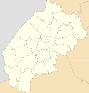
Sokal Raion (Ukrainian: Сокальський район, Sokal’s’kyi raion) is a raion (district) of Lviv Oblast (region) in western Ukraine. Its administrative center is the city of Sokal. It had a population of 98,123 in the 2001 Ukrainian Census.[2] Current population: 92,801 (2016 est.)[3].
The Sokal Raion has a total of 106 populated settlements: four are cities subordinate to the raion administration, including Belz, Velyki Mosty, Sokal, and Uhniv; one urban-type settlement, Zhvyrka; and 101 villages.[2]
The raion borders Poland to the west, Volyn Oblast to the north, and Lviv Oblast's Radekhiv Raion to the east, and the Kamianka-Buzka and Zhovkva Raions to the south.
The raion was established in 1939[2] with the annexation of Western Ukraine to the Ukrainian Soviet Socialist Republic. In 1951, the raion's administration was expanded to include territories ceded from the Lublin Voivodeship of the People's Republic of Poland during the 1951 Polish–Soviet territorial exchange. During the transfer, the cities of Bełz, Uhnów, Krystynopol, and Waręż were transferred to Ukraine.[4]
 St. Nicholas Greek Catholic Church in Belz.
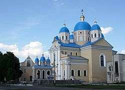 Holy Spirit Church in Chervonohrad, ca. 1750s.
 The city hall in Sokal.
 St. Mark's Church in Variazh.
See also
- Bieszczady County, Poland, which acquired the Ukrainian territories during the 1951 exchange
References
- ↑ "Leadership". Sokal Raion State Administration (in Ukrainian). Retrieved 16 February 2012.
- 1 2 3 "Sokal Raion, Lviv Oblast". Regions of Ukraine and their Structure (in Ukrainian). Verkhovna Rada of Ukraine. Retrieved 16 February 2012.
- ↑ "Чисельність наявного населення України (Actual population of Ukraine)" (PDF) (in Ukrainian). State Statistics Service of Ukraine. Retrieved 19 July 2016.
- ↑ Sylwester Fertacz, Krojenie mapy Polski: Bolesna granica. Alfa. Retrieved from the Internet Archive on 14 November 2011
External links
-
 Media related to Category:Sokal Raion at Wikimedia Commons
 - "Main". Sokal Raion State Administration (in Ukrainian). Retrieved 16 February 2012.