Sogndalsfjorden
| Sogndalsfjorden | |
|---|---|
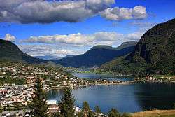 View of the fjord at Sogndalsfjorden | |
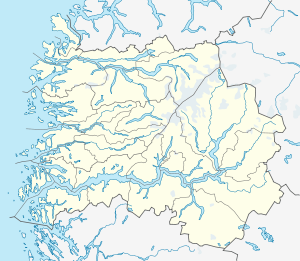 Sogndalsfjorden Location in Sogn og Fjordane county | |
| Location | Sogn og Fjordane county, Norway |
| Coordinates | 61°10′00″N 7°00′13″E / 61.1667°N 7.0035°ECoordinates: 61°10′00″N 7°00′13″E / 61.1667°N 7.0035°E |
| Primary outflows | Sognefjorden |
| Basin countries | Norway |
| Max. length | 20 kilometres (12 mi) |
| Max. width | 1.2 kilometres (0.75 mi) |
| Settlements | Sogndalsfjøra |
Sogndalsfjorden is a fjord in Sogndal Municipality in Sogn og Fjordane county, Norway. The 20-kilometre (12 mi) long fjord begins at the mouth of the river Arøyelvi, which flows out of the lake Hafslovatnet. It then flows to the southwest before emptying into the large Sognefjorden at its mouth between the villages of Nornes and Fimreite.

View of the fjord from the mouth looking east
The Norwegian National Road 5 highway crosses the fjord between the villages of Sogndalsfjøra and Kjørnes. The Norwegian County Road 55 runs along the northern shore of the fjord, the entire length of the fjord. The innermost part of the fjord is also known as the Barsnesfjorden.[1]
See also
References
- ↑ Store norske leksikon. "Sogndalsfjorden" (in Norwegian). Retrieved 2014-02-10.
This article is issued from Wikipedia - version of the 2/11/2014. The text is available under the Creative Commons Attribution/Share Alike but additional terms may apply for the media files.