Sobornyi District, Dnipro
| Sobornyi District Соборний район | ||
|---|---|---|
| Urban district | ||
| ||
 Map of the urban districts of Dnipropetrovsk. | ||
| Coordinates: 48°27′00″N 35°04′00″E / 48.45000°N 35.06667°ECoordinates: 48°27′00″N 35°04′00″E / 48.45000°N 35.06667°E | ||
| Country |
| |
| Municipality | Dnipropetrovsk Municipality | |
| Established | 16 March 1936[1] | |
| Government | ||
| • Chairman of District Council | Anton Zhosul | |
| Area | ||
| • Total | 44.093 km2 (17.024 sq mi) | |
| Population (2001 census) | ||
| • Total | 167,645 | |
| • Density | 3,800/km2 (9,800/sq mi) | |
| Time zone | EET (UTC+2) | |
| • Summer (DST) | EEST (UTC+3) | |
| Area code | +380 562 | |
| KOATUU | 1210136900[2] | |
| Website |
www | |
Sobornyi District (Ukrainian: Соборний район) is an urban district of the city of Dnipropetrovsk, in southern Ukraine.[3] It is located in the city's center on the right-bank of the Dnieper River.
It was created on 16 March 1936 out of the Kirovskyi and Fabrychno-Chechelivskyi districts.[1] In 1973, a portion of its territory was annexed to the newly created Babushkinskyi District. Before 26 November 2015 it was named Zhovtnevyi; on that day the district was renamed to comply with decommunization laws.[4]
Gallery
 View of a part of Sobornyi District
.jpg) Peremoha microdistrict is a part of Sobornyi District
Peremoha microdistrict is a part of Sobornyi District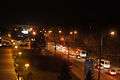 Sicheslav Embankment in Sobornyi district, Dnipropetrovsk
References
- 1 2 "History of the Zhovtnevyi Raion". Official site (in Ukrainian). Council of the Zhovtnevyi Raion of the city of Dnipropetrovsk. Retrieved 4 February 2015.
- ↑ "Zhovtnevyi District Council". Informational portal of the self-government in Ukraine (in Ukrainian). Rada.info. Retrieved 5 February 2015.
- ↑ "Zhovtnevyi Raion, Dnipropetrovsk Oblast, City of Dnipropetrovsk". Regions of Ukraine and their Structure (in Ukrainian). Verkhovna Rada of Ukraine. Retrieved 4 February 2015.
- ↑ (Ukrainian) Street signs were Dnipropetrovsk nedekomunizovanymy, Radio Svoboda (2 December 2015)
External links
| Raions | |||||||
|---|---|---|---|---|---|---|---|
| Cities | |||||||
| Urban-type settlements | |||||||
| Neighborhoods |
| ||||||
| |||||||
This article is issued from Wikipedia - version of the 6/30/2016. The text is available under the Creative Commons Attribution/Share Alike but additional terms may apply for the media files.