Snoqualmie Pass
| Snoqualmie Pass | |
|---|---|
|
I-90 through Snoqualmie Pass | |
| Elevation | 3,015 ft (919 m)[1] |
| Traversed by |
|
| Location | King / Kittitas counties, Washington, US[1] |
| Range | Cascade Range |
| Coordinates | 47°24′36″N 121°24′21″W / 47.41000°N 121.40583°WCoordinates: 47°24′36″N 121°24′21″W / 47.41000°N 121.40583°W[1] |
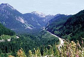
Snoqualmie Pass is a mountain pass that carries Interstate 90 through the Cascade Range in the U.S. State of Washington. The pass summit at an elevation of 3,015 feet (919 m) is on the county line between Kittitas County and King County.[1] Snoqualmie Pass has the smallest elevation of the three east-west mountain routes across Washington State that are kept open year-round, along with Stevens Pass (US 2) to the north, and White Pass (US 12) to the south. I-90 is the primary commercial artery between Seattle and points east, carrying an average of 29,000 vehicles through the pass per day.[3] The pass is also the only divided highway crossing East-West through Washington State.
The pass lends its name to a census-designated place (CDP) located at the summit (see: Snoqualmie Pass, Washington). Both the CDP and Snoqualmie Pass are named after the Snoqualmie people of the valley to the west.
Climate
Snoqualmie Pass as it climbs into the Cascades passes through a micro-climate characterized by considerable precipitation, and at times hazardous conditions for travelers. The average annual precipitation is over 100 inches; snowfall averages over 400 inches. The average annual number of days with measurable precipitation is over 170.
| Climate data for Snoqualmie Pass | |||||||||||||
|---|---|---|---|---|---|---|---|---|---|---|---|---|---|
| Month | Jan | Feb | Mar | Apr | May | Jun | Jul | Aug | Sep | Oct | Nov | Dec | Year |
| Record high °F (°C) | 56 (13) |
61 (16) |
67 (19) |
81 (27) |
84 (29) |
94 (34) |
101 (38) |
101 (38) |
101 (38) |
88 (31) |
65 (18) |
53 (12) |
98 (37) |
| Average high °F (°C) | 32.4 (0.2) |
37.1 (2.8) |
42.1 (5.6) |
48.9 (9.4) |
56.3 (13.5) |
62.9 (17.2) |
70.3 (21.3) |
69.3 (20.7) |
63.9 (17.7) |
53.8 (12.1) |
39.9 (4.4) |
33.7 (0.9) |
50.88 (10.48) |
| Average low °F (°C) | 20.9 (−6.2) |
23.3 (−4.8) |
26.0 (−3.3) |
30.0 (−1.1) |
34.2 (1.2) |
40.0 (4.4) |
45.6 (7.6) |
45.7 (7.6) |
41.1 (5.1) |
35.0 (1.7) |
28.2 (−2.1) |
23.5 (−4.7) |
32.79 (0.45) |
| Record low °F (°C) | −17 (−27) |
−15 (−26) |
0 (−18) |
7 (−14) |
21 (−6) |
27 (−3) |
31 (−1) |
27 (−3) |
22 (−6) |
11 (−12) |
0 (−18) |
−19 (−28) |
−19 (−28) |
| Average precipitation inches (mm) | 15.69 (398.5) |
11.89 (302) |
10.65 (270.5) |
5.99 (152.1) |
3.87 (98.3) |
3.74 (95) |
1.38 (35.1) |
2.23 (56.6) |
4.51 (114.6) |
9.32 (236.7) |
13.59 (345.2) |
17.17 (436.1) |
100.05 (2,541.3) |
| Average snowfall inches (cm) | 104.4 (265.2) |
75.3 (191.3) |
69.6 (176.8) |
25.8 (65.5) |
5.5 (14) |
0.3 (0.8) |
0.1 (0.3) |
0.0 (0) |
0.2 (0.5) |
7.4 (18.8) |
44.6 (113.3) |
86.9 (220.7) |
420.1 (1,067.2) |
| Source: [5] | |||||||||||||
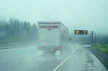
The rapidly changing conditions require special cautions, relayed to motorists via variable message displays along I-90.[6] Depending on traction they may call for tire chains to be installed, usually on large trucks but occasionally on smaller vehicles as well. Chain-up areas are provided along the side of the Interstate to facilitate the placement of chains. The pass has been subjected to closures when weather conditions become extreme.[7]
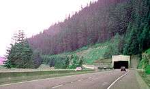
A snow shed, constructed in 1950 when the road was known as US-10, formerly covered the westbound lanes, but it has been replaced by 'avalanche bridges', as of April 2014.[8] The use of sheds (very rare on Interstates) is an admission that plowing cannot keep up with snowfall and avalanches.
WSDOT maintains cameras at selected locations along the pass to monitor weather conditions. Some of these cameras can be viewed via the internet.[9]
Recreation
The area around Snoqualmie Pass consists of mountain chalets that are mainly seasonally occupied by residents of the Seattle metropolitan area, with approximately 150 year-round residents. Winter sports are the main draw, but outdoor recreation is available year round.
The Pacific Crest Trail crosses through Snoqualmie Pass and a variety of other trails are also available for hiking and climbing in the summer, cross-country skiing and snowshoeing during the winter months.
Snoqualmie Pass is also the site of the Summit at Snoqualmie, a group of alpine ski areas managed by Boyne USA Resorts. The Summit consists of four ski areas: Alpental, Summit West (formerly named Snoqualmie Summit), Summit Central (formerly Ski Acres), and Summit East (formerly Hyak).[10] The Summit at Snoqualmie is the closest ski area to Seattle.
Snowmobiling just east of the pass is also popular during the winter months. Also in the summer and fall, paragliders and hang gliders may be seen flying above the valley, along the ridge and landing at Lake Keechelus.
History
Snoqualmie Pass was well known to the Native Americans of the region. Hudson's Bay Company trappers and traders were active in the Snoqualmie and Yakima valleys during the early 19th century. They knew about Snoqualmie Pass but information about their use of it is vague. A possible early use of the pass was that of A.C. Anderson, who drove cattle across the Cascades in 1841, via a pass he called "Sinahomish Pass".[11]
George B. McClellan and his lieutenant Abiel W. Tinkham explored the Snoqualmie Pass region in 1853 and 1854. Their goal was to find a pass better suited for a railroad than Naches Pass, where the Naches Trail crossed the Cascade Mountains. They explored from the east side of the mountains, reaching the vicinity of Yakima Pass. Tinkham continued down the west side via the Cedar River. McClellan decided not to examine Snoqualmie Pass itself because of unfavorable reports from Natives.[11]
In 1856 Major J.H.H. Van Bokkelen, then of the Washington Territory Volunteers (militia), crossed Snoqualmie Pass on a scouting mission. In 1858 several large pack trains bound for mines east of the Cascades crossed the pass. In 1865 a number of Seattle citizens, including Arthur A. Denny, explored the Cedar River, Snoqualmie Pass, and Naches Pass. They reported that Snoqualmie Pass route was a better choice for a road than the old Indian trail over Yakima Pass. By 1867 a toll road had been built over Snoqualmie Pass. Intended to be suitable for wagons, for years the road was only usable by pack trains and for cattle drives.[11]
The Chicago, Milwaukee and St. Paul Railway (the "Milwaukee Road") completed a line through Snoqualmie Pass in 1909, traveling under the summit via the 2.3 mile Snoqualmie Tunnel, which is now used as a multi-use trail for bicyclists and hikers.[12] The same year, an improved wagon road was built over the pass. The Sunset Highway was opened through the pass in 1915.[13]
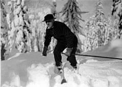
In 1927, the road over the pass became U.S. Route 10. It began to be plowed and kept open during winter in 1931.[14] By 1933, the first alpine ski hill was cleared at Snoqualmie Pass. In 1934, US 10 was finally paved.
In 1969, they began to build Interstate 90 across the pass.[15][16][17]
Since 1991, the Mountains to Sound Greenway Trust has acted to protect the scenic value of the I-90 corridor over Snoqualmie Pass.[18]
See also
References
- 1 2 3 4 "Snoqualmie Pass". Geographic Names Information System. United States Geological Survey. Retrieved 2015-08-31.
- ↑ Google Maps Accessed 2015-08-31
- ↑ WSDOT - Annual Traffic Report Accessed 2015-08-31
- ↑ https://www.youtube.com/watch?v=EFqeSFcPWZU
- ↑ "SNOQUALMIE PASS, WASHINGTON (457781)". Western Regional Climate Center. Retrieved July 11, 2016.
- ↑ Smarter Highways 102: Variable Speed Limits
- ↑ Snoqualmie Pass reopens after hours of closure - KOMO News
- ↑ http://www.wsdot.wa.gov/Projects/I90/SnoqualmiePassEast/HyaktoKeechelusDam/SnowshedRemoval.htm
- ↑ WSDOT - Snoqualmie Pass Road and Weather Conditions
- ↑ Summit at Snoqualmie
- 1 2 3 Beckey, Fred (2000). Cascade Alpine Guide: Climbing and High Routes: Columbia River to Stevens Pass (3rd ed.). The Mountaineers. p. 149. ISBN 978-0-89886-577-6.
- ↑ Snoqualmie Tunnel gives cyclists, riders cool new link - The Seattle Times Accessed 2015-08-31
- ↑ Washington State Legislature (1913). "An act relating to public highways, classifying the same and naming and fixing the routes of certain state roads.". Session Laws of the State of Washington. Olympia, WA: State of Washington. 1913 chapter 65, p. 221.: "A highway starting from the Pacific Highway at Renton, Washington; thence over the most feasible route by the way of Snoqualmie Pass into the Yakima River Valley; thence by way of Wenatchee, over the most feasible route, through Waterville and Spokane, to the state boundary, which shall be known as the Sunset Highway."
- ↑ Washington state department of transportation. (n.d.). Retrieved from http://www.wsdot.wa.gov/Projects/I90/SnoqualmiePassEast/History.htm
- ↑ Bureau of Public Roads & American Association of State Highway Officials (November 11, 1926). United States System of Highways Adopted for Uniform Marking by the American Association of State Highway Officials (Map). 1:7,000,000. Washington, DC: U.S. Geological Survey. OCLC 32889555. Retrieved November 7, 2013 – via University of North Texas Libraries.
- ↑ Department of Highways, Highway Map: State of Washington, Revised to April 1, 1933
- ↑ Department of Highways, Highways of the State of Washington (Rand McNally), 1939
- ↑ About Us - Mountains to Sound Greenway Accessed 2015-08-31
External links
| Wikimedia Commons has media related to Snoqualmie Pass. |