Smoky Hill River
| Smoky Hill River | |
| Aahkawirarahkata, Chetolah, Oke-see-sebo[1], River of the Padoucas[2] | |
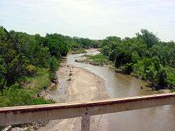 Smoky Hill River near Assaria, Kansas | |
| Country | United States |
|---|---|
| State | Colorado, Kansas |
| Tributaries | |
| - left | North Fork Smoky Hill River, Big Creek, Saline River, Solomon River |
| - right | Ladder Creek |
| Source | |
| - location | Cheyenne County, Colorado |
| - elevation | 4,640 ft (1,414 m) |
| - coordinates | 38°57′01″N 102°34′49″W / 38.95028°N 102.58028°W [1] |
| Mouth | Kansas River |
| - location | Junction City, Kansas |
| - elevation | 1,040 ft (317 m) |
| - coordinates | 39°03′36″N 98°46′04″W / 39.06000°N 98.76778°WCoordinates: 39°03′36″N 98°46′04″W / 39.06000°N 98.76778°W [1] |
| Length | 575 mi (925 km) |
| Basin | 19,260 sq mi (49,883 km2) |
| Discharge | for USGS 06877600 at Enterprise, KS[3] |
| - average | 1,540 cu ft/s (44 m3/s) |
| - max | 207,000 cu ft/s (5,862 m3/s) |
| - min | 38 cu ft/s (1 m3/s) |
| Watersheds | Smoky Hill-Kansas-Missouri-Mississippi |
| Reservoirs | Cedar Bluff Reservoir, Kanopolis Lake |
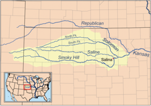 Map of the Smoky Hill drainage basin | |
The Smoky Hill River is a 575-mile (925 km)[4] river in the central Great Plains of North America, running through the U.S. states of Colorado and Kansas.[5]
Names
The Smoky Hill gets its name from the Smoky Hills region of north-central Kansas through which it flows. American Indians living along the Smoky Hill considered it and the Kansas River to be the same river, and their names for it included Chetolah and Okesee-sebo. Early maps of European explorers called the river (also in combination with the Kansas River) the River of the Padoucas as its source is located in what was then Padouca (Comanche) territory.[2]
The USGS lists a number of other variant names for the Smoky Hill River, including Chitolah River, Fork of the Hill Buckaneuse, La Fourche de la Cote Boucaniere, La Touche de la Cote Bucanieus, Manoiyohe, Pe P'a, Sand River, Shallow River, Smoky Creek, Branche de la Montagne a la Fumee, Ka-i-urs-kuta, Oke-see-sebo River, and Rahota katit hibaru, among others.[1]
Geography
The Smoky Hill River originates in the High Plains of eastern Colorado and flows east. Both the main course of the river and the North Fork Smoky Hill River rise in northern Cheyenne County, Colorado.[1][6] The two streams converge roughly 5 miles (8 km) west of Russell Springs in Logan County, Kansas.[6] From there, the river continues generally eastward through the Smoky Hills region. The Saline River joins the river in eastern Saline County.[7] The Solomon River, joins the Smoky Hill in western Dickinson County.[8] The Smoky Hill joins the Republican River at Junction City, Kansas to form the Kansas River.[1]
The Smoky Hill River directly drains an area of 8,810 square miles (22,800 km2). The combined Smoky Hill-Saline Basin drains 12,229 square miles (31,670 km2).[9] The entire Smoky Hill drainage basin covers approximately 20,000 square miles (52,000 km2), including most of north-central and northwestern Kansas.[10] Via the Kansas and Missouri Rivers, the Smoky Hill is part of the Mississippi River watershed.
The Smoky Hill feeds two reservoirs: Cedar Bluff Reservoir in Trego County and Kanopolis Lake in Ellsworth County.[9]
The largest city along the Smoky Hill River is Salina. Besides Junction City, other Kansas towns along the river include Ellsworth, Marquette, Lindsborg, and Abilene.[11]
History
The earliest known reference to the river was on a 1732 map by French cartographer Jean Baptiste Bourguignon d'Anville who labeled it the "River of the Padoucas". A 1758 map referred to it as the "Padoucas River". An early reference to the river as the Smoky Hill was by American explorer Zebulon Pike during his 1806 expedition to visit the Pawnee.[2] The Kansas-Nebraska Act of 1854 established Kansas Territory, which included the entire length of the Smoky Hill River.[12]
With the onset of the Pike's Peak Gold Rush in 1858, an ancient American Indian trail along the river known as the Smoky Hill Trail provided the shortest, fastest route west across Kansas.[13][14] Beginning in 1865, the trail served as the route for the short-lived Butterfield Overland Despatch.[2] To protect travelers, the U.S. Army established several forts along the trail, including Fort Downer, Fort Harker, Fort Hays, Fort Monument, and Fort Wallace.[15] Before American colonization, the land along the Smoky Hill River was favored hunting ground for the Plains Indians. In 1867, the Comanche and the Kiowa, and in 1868, the Sioux and the Arapaho signed treaties withdrawing their opposition to the construction of a railroad along the Smoky Hill River.[2] The Kansas Pacific Railway was completed in 1870, rendering the Smoky Hill Trail obsolete.[16]
In 1948, the U.S. Army Corps of Engineers finished construction of a dam on the Smoky Hill for flood control in southeastern Ellsworth County creating Kanopolis Lake.[17] In 1951, the United States Bureau of Reclamation completed another dam on the river, this one for irrigation as well as flood control, in southeastern Trego County, Kansas creating Cedar Bluff Reservoir.[18]
See also
References
- 1 2 3 4 5 6 U.S. Geological Survey Geographic Names Information System: Smoky Hill River
- 1 2 3 4 5 Root, George A. (February 1935). "Ferries in Kansas, Part VI -- Smoky Hill River". Kansas Historical Quarterly. 4 (1): 3–22.
- ↑ "Water resources data for the United States, Water Year 2009; gage 06877600, Smoky Hill River at Enterprise, KS" (PDF). USGS. Retrieved 1 August 2010.
- ↑ "National Hydrography Dataset". National Hydrography Dataset. United States Geological Survey. Retrieved 14 June 2011.
- ↑ Smoky Hill River. (2009). In Encyclopædia Britannica. Retrieved July 22, 2009, from Encyclopædia Britannica Online: http://www.britannica.com/EBchecked/topic/550068/Smoky-Hill-River
- 1 2 U.S. Geological Survey Geographic Names Information System: North Fork Smoky Hill River
- ↑ U.S. Geological Survey Geographic Names Information System: Saline River
- ↑ U.S. Geological Survey Geographic Names Information System: Solomon River
- 1 2 "Smoky Hill-Saline Basin". Kansas Water Office.
- ↑ Blackmar, Frank W., ed. (1912). "Smoky Hill River". Kansas: a cyclopedia of state history, embracing events, institutions, industries, counties, cities, towns, prominent persons, etc. 2. Chicago: Standard. pp. 708–709.
- ↑ "KDOT Official Transportation Map 2015-2016" (PDF). Kansas Department of Transportation. Retrieved 2015-09-11.
- ↑ Gower, Calvin W. (Spring 1967). "Kansas Territory and Its Boundary Question: "Big Kansas" or "Little Kansas"". Kansas Historical Quarterly. 33 (1): 1–12. Retrieved 2009-07-25.
- ↑ Gower, Calvin W. (Summer 1959). "The Pike's Peak Gold Rush and the Smoky Hill Route, 1859-1860". Kansas Historical Quarterly. 25 (2): 158–171. Retrieved 2009-07-25.
- ↑ "Smoky Hill Trail : History". Cherry Creek Valley Historical Society. Retrieved 2009-07-25.
- ↑ Chinn, Stephen; Richard A. Ensminger (1993-10-11). "Kansas Forts". Retrieved 2009-07-25.
- ↑ "Cherry Creek State Park Marker Text". Colorado Historical Society. 2002. Retrieved 2009-07-25.
- ↑ "History of Kanopolis Dam". U.S. Army Corps of Engineers.
- ↑ "Cedar Bluff Unit Project". Bureau of Reclamation.