Smeerenburg
| Smeerenburg | |
|---|---|
| Dutch-Danish whaling station (1619–1657) | |
 Smeerenburg Location in northwestern Svalbard | |
| Coordinates: 79°43′54″N 10°59′42″E / 79.73167°N 10.99500°E | |
| Country |
|
| Syssel | Svalbard |
| Island | Spitsbergen |
| Settled | 1619 |
| Closure | 1657 |
| Population | |
| • Total | 0 |
| Time zone | CET (UTC+2) |
| • Summer (DST) | +3 (UTC) |


The settlement of Smeerenburg on Amsterdam Island in northwest Svalbard was founded by Danish and Dutch whalers in 1619 as one of Europe's northernmost outposts.
Reality
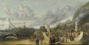
During the first intensive phase of the Spitsbergen whale fishery, Smeerenburg served as the centre of operations in the north. (The name Smeerenburg, in Dutch, literally means "blubber town"). The image at right shows the concretized remnants of whale oil that built up around the large (ca. 2-3m diameter) copper kettles in which the blubber was rendered. Leftover blubber was used as fuel for the fires.
The site of Smeerenburg was first occupied by the Dutch in 1614, when ships from the Amsterdam chamber of the Noordsche Compagnie (Northern Company) established a temporary whaling station here with tents made of canvas and crude, temporary ovens. In 1615, 1616, and 1618 the Dutch again occupied the site. In 1619, a 500-ton ship with timber and other materials was sent to Spitsbergen.[1] The tents and temporary ovens were replaced with wooden structures and copper kettles "set in a permanent fashion on a brick foundation, with a brick fireplace beneath and a chimney for the smoke."
In its first year only Amsterdam and the Danes occupied Smeerenburg, the former to the east and the latter to the west. In 1619 and 1620 the Danish ships that went to Smeerenburg were sent by merchants from Copenhagen, while those that went there in 1621 and 1622 were sent by a royal undertaking. In 1623 two Basque ships employed by the Danes arrived at Smeerenburg and began taking whaling gear from the Danish huts before they were driven away by the Dutch. In 1625, when the Danish-employed Basque ships arrived at their place in Smeerenburg they found that their station had been damaged, the work of the Dutch and English in the previous season.[2] After 1625 the Danes were expelled by the Dutch, their place being occupied by the Hoorn, Enkhuizen, and Vlissingen chambers. By 1626 there were five big "huts" at Smeerenburg, and by 1633 all the chambers of the Northern Company were represented at the settlement.[3]
In its heyday (1630s), Smeerenburg was made up of 16–17 buildings,[4] including a fort at its centre, built in or before 1631 to ward off the Danish and other interlopers.[5] The alleys between the buildings were cobbled with drainage gullies, allowing the men to walk dry-shod. There were seven double (and one single) ovens situated in front of the buildings. Amsterdam had three of the buildings and two of the double ovens, while to the west were the stations of the Middelburg, Veere, Vlissingen, Enkhuizen, Delft, and Hoorn chambers. During this time there were as many as 200 men[6] working ashore, boiling blubber into oil, flensing whales, and coopering casks to pour the oil into.
Following the destruction of a Dutch station in Jan Mayen by Danish-employed Basque ships in 1632, the Dutch sent seven men, led by Jacob Segersz. van der Brugge, to over-winter at Smeerenburg in 1633–34.[7] All seven men survived, prompting another wintering by another group of seven sailors in 1634–35.[8] Unfortunately, all of them died, and the experiment was abandoned.
Smeerenburg’s decline began in the early to mid-1640s.[9] We hear of it still in use by the Hoorn chamber as late as 1657.[10] Around 1660, with the transition to processing blubber into oil on return to port and expansion into pelagic whaling, the settlement was abandoned.[11]
In 1973 the ruins of Smeerenburg became part of Norway's North-West Spitsbergen National Park.[12]
Myth
The size of Smeerenburg has been greatly exaggerated by many authors. William Scoresby (1820) claimed 200 to 300 ships and 12,000 to 18,000 men visited Smeerenburg during the short summer season.[13] The Norwegian explorer Fridtjof Nansen (1920) made similar claims, stating that hundreds of ships anchored along the flat of Smeerenburg where ten thousand people visited a complete town with stalls and streets. Besides the tryworks, smithies and workshops, there were shops, churches, fortifications, gambling dens and even brothels.[14]
Such claims have no basis in reality, as noted above. No more than fifteen ships and 400 men[15] would have visited Smeerenburg during its peak in the 1630s. There were no shops, churches or brothels, though there was a single fort with two guns.[16] Unfortunately, despite the results of archaeological excavations that took place in the period 1979–81, modern authors still sometimes repeat the fabulous legends told of Smeerenburg.[17]
Notes
- ↑ Ellis (1991), p. 62
- ↑ Dalgård (1962), p. 146-47, 253
- ↑ Conway (1906), p. 135-37
- ↑ Prestvold (2001), p. 10
- ↑ Dalgård (1962), p. 164
- ↑ Ellis (1991), p. 64
- ↑ Conway (1904), p. 79-168
- ↑ Conway (1904), p. 169-72
- ↑ Conway (1906), p. 186-87
- ↑ Dalgård (1962), p. 258
- ↑ Prestvold (2001), p. 8
- ↑ Comments made on location by Oceanwide expedition guide, 3 August 2005; confirmed by Prestvold, p. 2
- ↑ Scoresby (1820), p. 143.
- ↑ Prestvold (2001), p. 12
- ↑ It is said that two hundred men slept or worked ashore at one time, but given the continual sunlight the men would have worked in shifts. So 200 men would have slept while a correspondent number would have worked.
- ↑ Vaughan (2007), p. 87.
- ↑ Archibald (Whalehunters: Dundee and the Arctic Whalers, 2004), p. 9; Francis (A History of World Whaling, 1990), p. 39-40; Roberts (Four Against the Arctic, 2005), p. 44; among others.
References
- Conway, William Martin (1904). Early Dutch and English Voyages to Spitsbergen in the Seventeenth Century. London.
- Conway, William Martin (1906). No Man's Land: A History of Spitsbergen from Its Discovery in 1596 to the Beginning of the Scientific Exploration of the Country. Cambridge, At the University Press.
- Dalgård, Sune (1962). Dansk-Norsk Hvalfangst 1615–1660: En Studie over Danmark-Norges Stilling i Europæisk Merkantil Expansion. G.E.C Gads Forlag.
- Ellis, Richard (1991). Men & Whales. Alfred A. Knopf. ISBN 1-55821-696-0.
- Prestvold, Kristin. 2001. Smeerenburg Gravneset: Europe's First Oil Adventure. Translated by Richard Wooley. [pamphlet]. Longyearbyen, NO: Governor of Svalbard, Environmental Section. (24 pp., no ISBN, available from the gift shop of the Svalbard Museum, Longyearbyen, NO.)
- Scoresby, William (1820). An Account of the Arctic Regions with a History and a Description of the Northern Whale-Fishery. Edinburgh.
- Vaughan, Richard (2007). The Arctic: A History. Stroud, Sutton.
Coordinates: 79°43′54″N 10°59′42″E / 79.73167°N 10.99500°E