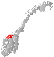
Smøla
| Smøla kommune | |||
|---|---|---|---|
| Municipality | |||
 | |||
| |||
 Smøla within Møre og Romsdal | |||
| Coordinates: 63°24′7″N 8°1′45″E / 63.40194°N 8.02917°ECoordinates: 63°24′7″N 8°1′45″E / 63.40194°N 8.02917°E | |||
| Country | Norway | ||
| County | Møre og Romsdal | ||
| District | Nordmøre | ||
| Administrative centre | Hopen | ||
| Government | |||
| • Mayor (2011) | Roger Osen (AP) | ||
| Area | |||
| • Total | 281.82 km2 (108.81 sq mi) | ||
| • Land | 270.44 km2 (104.42 sq mi) | ||
| • Water | 11.38 km2 (4.39 sq mi) | ||
| Area rank | 285 in Norway | ||
| Population (2013) | |||
| • Total | 2,180 | ||
| • Rank | 321 in Norway | ||
| • Density | 8.1/km2 (21/sq mi) | ||
| • Change (10 years) | -3.8 % | ||
| Demonym(s) | Smølværing[1] | ||
| Time zone | CET (UTC+1) | ||
| • Summer (DST) | CEST (UTC+2) | ||
| ISO 3166 code | NO-1573 | ||
| Official language form | Neutral | ||
| Website |
www | ||
|
| |||

Smøla is a municipality in Møre og Romsdal county, Norway. It is part of the Nordmøre region. The administrative centre of the municipality is the village of Hopen, other villages include Dyrnes, Råket, and Veiholmen.
General information
The municipality of Smøla was established on 1 January 1960 after the merger of the municipalities of Edøy, Brattvær, and Hopen. The initial population was 4,046. The boundaries have not changed since that time.[2]
Name
The municipality is named after the main island of Smøla (Old Norse: Smyl or Smjöl). The name is probably related to Modern Norwegian smule and smuldre which means "crumble", referring to the thousands of small islands and islets around the main island.[3] Researchers at the Technical University of Berlin have claimed that Smøla is the island which Pytheas called Thule (Greek: Θούλη, Thoúlē).[4]
Coat-of-arms
The coat-of-arms is from modern times; they were granted in 1989. The arms show two white seagulls on a red background. This design was chosen to highlight the fact that this is an island community.[5]
- See also: Coat-of-Arms of Hasvik
Churches
The Church of Norway has three parishes within the municipality of Smøla. It is part of the Ytre Nordmøre deanery in the Diocese of Møre.
| Parish (Sokn) | Church Name | Year Built | Location of the Church |
|---|---|---|---|
| Brattvær | Brattvær Church | 1917 | Brattvær |
| Edøy | Edøy Church | 1885 | Edøy |
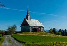
| Old Edøy Church | c. 1190 | Edøya | |
| Hopen | Hopen Church | 1892 | Hopen |
Geography

The municipality of Smøla is located north of the town of Kristiansund, off the western coast of Norway. The municipality consists of the main island of Smøla and more than 3,000 smaller ones. The 214-square-kilometre (83 sq mi) main island is very flat, the highest peak reaches 63 metres (207 ft) above sea level. Almost all of the land area consists of marshes and cliffs; only 5% is cultivated into agricultural land. Other minor islands in the municipality include Edøya, Kuli, and Veiholmen. The municipality is separated from the rest of Norway by the Edøyfjorden to the south.
Due to the vast number of small islands surrounding Smøla, there are several lighthouses. The three most notable ones are Haugjegla Lighthouse (north of Smøla), Skalmen Lighthouse, (northwest of Smøla), and Tyrhaug Lighthouse (southeast of Smøla in the Edøyfjorden).
Scientists of the Institute of Geodesy and Geoinformationtechnique of the Technical University of Berlin were testing the antique maps of Ptolemy and recognized a pattern of calculation mistakes that occurred when one tried to convert the old coordinates from Ptolemy into modern cartographical maps. The scientists believe that, when one compensates for these mistakes, the mythological location Thule corresponds to the island of Smøla.[6]
Energy

On 5 September 2002, Statkraft announced the opening of the Smøla Wind Farm, a 40-megawatt (54,000 hp) wind project comprising twenty 2 MW wind turbines by Norway's King Harald V. This corresponds to phase one of the wind project, which when completed will have a total installed capacity of more than 110 MW. Phase two was opened in September 2005 and included forty-eight 2.3 MW wind turbines. All in all, the wind energy production project consists of 68 windmills, making it among the largest wind projects in Europe. With a total generating capacity of 150 megawatts (200,000 hp), the Smøla wind farm's 68 turbines account for more than half of the installed wind power capacity in Norway. The total generating capacity is equivalent to 450 GWh of electricity per year, which corresponds to the average annual power consumption of 22,500 Norwegian households.[7]
Attractions
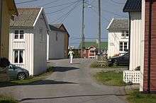
- Veiholmen is a large fishing village, north of the main island.
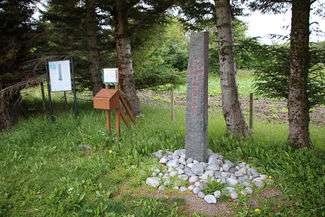
- Kulisteinen (the Kuli stone), probably one of the best remains which tells about early Christianity in Norway. On one side it has a large cross, which was well known for a long time. Less well known was a runic inscription on the rim of the stone.
- Old Edøy Church, a restored church dating back to about the year 1190.
- Deep-sea fishing is a part of the natural environment of Smøla. Smøla provides facilities, guided fishing trips and possibilities for renting fisherman’s boats and needed equipment. Participants can expect to catch a large selection of deep sea fish in this area: herring, cod, redfish, perch, monkfish, Atlantic halibut, plaice, carp, char, mackerel, and others.
References
- ↑ "Navn på steder og personer: Innbyggjarnamn" (in Norwegian). Språkrådet. Retrieved 2015-12-01.
- ↑ Jukvam, Dag (1999). "Historisk oversikt over endringer i kommune- og fylkesinndelingen" (PDF) (in Norwegian). Statistisk sentralbyrå.
- ↑ Store norske leksikon. "Smøla" (in Norwegian). Retrieved 2013-04-07.
- ↑ http://old.dagogtid.no/nyhet.cfm?nyhetid=1456%20
- ↑ "Møre og Romsdal fylke" (in Norwegian). Retrieved 2008-10-25.
- ↑ Kleineberg, Andreas; Marx, Christian; Knobloch, Eberhard; Lelgemann, Dieter (2010). "Germania und die Insel Thule. Die Entschlüsselung von Ptolemaios´ "Atlas der Oikumene"". Darmstadt: Wissenschaftliche Buchgesellschaft.
- ↑ "http://www.statkraft.com/presscentre/news/statkraft-takes-over-smola-ll.aspx". Statkraft. 25 August 2010. Retrieved 2010-12-12. External link in
|title=(help)
External links
| Wikivoyage has a travel guide for Møre og Romsdal. |
- Statkraft
- Veiholmen.com (Norwegian)
- http://www.smola.kommune.no