Slovene Istria
| Slovene Istria Slovenska Istra (Slovene) Istria slovena (Italian) | |
|---|---|
| Region | |
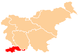 Map of Slovenia highlighting the region location | |
| Population (2002)[1] | |
| • Total | 93,089 |
| Time zone | CET (UTC+01) |
| • Summer (DST) | CEST (UTC+02) |
Slovene Istria (Slovene: Slovenska Istra, Italian: Istria slovena) is a region in southwest of Slovenia. It comprises the northern part of the Istrian peninsula, and it is part of the wider geographical-historical region known as the Slovene Littoral (Primorska). Its largest urban center is Koper. Other large settlements are Izola, Piran and Portorož. The whole region has around 120 settlements. In its coastal area, both the Slovene and Italian languages are official.
The Slovene Riviera (Slovenska obala in Slovene) is located in Slovene Istria; both terms are sometimes used interchangeably, especially in the media, although the Slovenian Istria includes a wider geographical area.
History

The Istrian peninsula was known to Romans as the terra magica. Its name is derived from the Histri, an Illyrian tribe who, as accounted by the geographer Strabo, lived in the region. Romans described them as pirates who were hard to conquer due to the difficulty of navigating their territory. After two military campaigns, Roman legions finally subdued them in 177 BC. A lot of remains of ancient harbours and settlements still remain today, mostly in Ankaran, Hrvatini, Izola, Koper and Piran.
With the fall of the Western Roman Empire in 476, Istria was conquered by the Goths, the Byzantines. With the end of the 6th century, Carantanians arrived and built their first permanent settlement around the year 700. During Byzantine rule, it was shortly ruled by Avars. Istria was annexed by the Lombards in 751 and by the Avars in 774. It came under Frankish rule during the reign of Charlemagne, when his son Carloman conquered the peninsula in 789, and was incorporated into the Carolingian March of Friuli.
In 952 King Otto I of Germany ceded Istria together with the vast March of Verona and Aquileia to the Dukes of Bavaria. From 976 Verona was ruled by the Dukes of Carinthia, until in 1040 King Henry III established the separate March of Istria, which thereafter successively was controlled by various noble dynasties such as the Bavarian House of Andechs (temporarily ruling as Dukes of Merania). In 1208/09 it fell to the Patriarchs of Aquileia, while large parts of the estates were held by the comital House of Gorizia.
From 1267 the Republic of Venice gradually annexed the Istrian coast, aided also by the strong presence of the autochthonous romance-speaking communities; the region regained the oversea ties which were loosened by the barbarian invasions. The coastal area somewhat reflowered, but the venetian government enmity with Austria and the Ottoman empire limited the relations with the hinterland. After Napoleon's triumph in Padania, the Treaty of Campo Formio in 1797 gave most of Venetian Republic and all of the peninsula to the Habsburg.

Between 1805 and 1813, it was under French rule, first as part of the Napoleonic Kingdom of Italy, then as a province within the Illyrian Provinces. In 1813, it became part of the Austrian Empire, which unified the whole peninsula under a single administration with the capital in Pazin. In 1860, Istria became an autonomous province within the Austrian Littoral, with its own Provincial diet (Assembly). What is today Slovenian Istria was divided among the administrative district of Koper and Volosko: the former extended to the present-day municipalities of Koper, Izola and Piran, while the latter extended to the present-day municipality of Hrpelje-Kozina.
After World War I, according to the peace Treaty of Rapallo, in 1920 Istria became part of Italy. Fascism and, later, Nazi occupation spoiled ethnic relations. After World War II, Istria was assigned to Yugoslavia. As a consequence, between 1945 and 1954, an estimated 350,000 ethnic Italians left the Slovenian Istria in the so-called Istrian exodus, together with several thousand Slovenes. Between 1947 and 1954, Slovenian Istria was divided between the Federal People's Republic of Yugoslavia and the Free Territory of Trieste. After the abolition of the Free Territory in 1954, the region became part of the People's Republic of Slovenia within Yugoslavia.
Between the 1950s and 1970s, the region experienced profound changes. A significant portion of the rural population moved to the coastal towns, which remained semi-deserted after the Istrian Exodus. The local Italian population shrank in number. Many villages were depopulated, while the towns grew in number. Koper developed in an important portal town, and one of the major centres of Slovenian economy.
Geography
The 43 kilometers long coastline of Slovenian Istria has numerous peninsulas and bays such as Piran peninsula and Gulf of Piran, Gulf of Koper and Ankaran peninsula on which is at the same time one of only two nature reserves on Slovenian coast, the other one being the Strunjan reserve.[2] In the Strunjan reserve lies the only coastal cliff in Slovenia which is at the same time the only cliff in Trieste Bay. The inner part of the region is more hilly, with various types of landscape, including the most known karst landscape in the Kras region.
The most important water-flows in Slovenian Istria are the Dragonja and Rižana rivers.
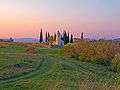 Rural landscape in Slovenian Istria
 Dragonja Valley
 Karst landscape near Osp
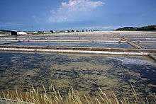
 Moon Bay, Strunjan
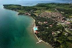 Ankaran Peninsula
 Škocjan Inlet
Economy and transportation
Slovenian Istria is the second most prosperous region in Slovenia after Central Slovenia. The two most important economic branches are transport and tourism, followed by services and industry.
The Port of Koper is the only international port in Slovenia and one of the largest in the Adriatic Sea. It is considered as one of the strategically most important firms in Slovenian economy.
Tourism
Tourism is one of the main branches of income on the Slovenian coast, especially in Portorož, Piran, Izola and Sečovlje,
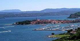
where the most important historical monument is the Venetian Gothic Mediterranean town of Piran. The neighboring town of Portorož is a popular modern tourist resort, offering entertainment in gambling tourism. The former fishermen town of Izola has also been transformed into a popular tourist destination; many tourists also appreciate the old Medieval center of the port of Koper, which is however less popular among tourists than the other two Slovenian coastal towns. Near the village of Sečovlje there is the Sečovlje Salina Nature Park, which is a cultural heritage site and a tourist attraction.
Among other less important are the Strunjan nature reserve, various small camps in the nature, village of Ankaran and Debeli Rtič.
Agriculture
Slovenian Istria is especially renowned for its wines and olive oil. The most common wine varieties are refosco (red) and malvasia (white). Other products include cherries, figs, and vegetables, such as radicchio, tomatoes and asparagus.
Language

In the Slovenian Riviera and some villages in the interior, both Slovene and Italian are official languages. In the rest of Slovenian Istria, comprising most of its rural area, only Slovene is recognized as official language.
According to the 2002 census, Slovene is spoken as the first language by 70,2% of the inhabitants of Slovenian Istria, Italian by 3,3%, and various forms of Croatian by 16% of the population. The highest percentage of Italian speakers is in the municipality of Piran (7%), while the highest percentage of Croatian speakers is in Izola (31%). Polls show that the majority of the population in Slovenian Istria is fluent in four languages: Slovene, Italian, Croatian and English.
Slovene-Italian bilingualism
Both Slovene and Italian are official in the municipalities of Piran, Izola and Koper. However, Italian is co-official only in the strip of land on the coast, traditionally inhabited by Istrian Italians. In the villages in the interior, only Slovene is official.
According to law, all official signs are to be written in both languages, as should all public notifications. Italian is to be used in all public offices in the bilingual area. For most jobs in the public administration and other public offices, the knowledge of both Slovene and Italian is required. Beside Slovene language schools, there are also elementary, high and grammar schools with Italian as the language of instruction. Pupils may choose between an education in Slovene or Italian; in either case, the other official language is being taught during the whole period of education, in order to provide that all residents speak both languages. At the state-owned University of Primorska, however, which is also established in the bilingual area, Slovene is the only language of instruction (although the official name of the university additionally includes the Italian version).
Italian may be used in the municipal assemblies of Koper, Izola and Piran, although in practice almost all discussions are carried out in Slovene.
Dialects
In the rural areas of Slovenian Istria, the Istrian dialect of Slovene is still spoken. It is divided into two sub-dialects: the Rižana subdialect, spoken in the northern areas, and the Šavrini Hills subdialect, spoken in the southern areas. In the municipality of Hrpelje-Kozina, the Inner Carniolan dialect is spoken. In a few villages on the border with Croatia, the Čičarija dialect is spoken, which is considered a transitional dialect between Slovene and Čakavian Croatian.
In the urban areas, a hybrid regional version of Slovene is spoken, which is phonetically very different from the rural dialects. It developed after World War Two, when new settlers from all Slovenia (many of whom from Slovenian Styria) moved into the towns, left by the Istrian Italians. Although it has borrowed many words from the Istrian dialect, it is markedly distinguishable from it.
Traditionally, the Istrian Italians living in Slovenian Istria have spoken the Venetian language, which is nowadays being increasingly replaced by standard Italian.
References
External links
Coordinates: 45°33′9.09″N 13°54′11.51″E / 45.5525250°N 13.9031972°E