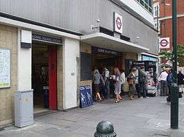
Sloane Square tube station
| Sloane Square | |
|---|---|
|
Entrance on Sloane Square | |
 Sloane Square Location of Sloane Square in Central London | |
| Location | Sloane Square |
| Local authority | Royal Borough of Kensington and Chelsea |
| Managed by | London Underground |
| Number of platforms | 2 |
| Fare zone | 1 |
| London Underground annual entry and exit | |
| 2012 |
|
| 2013 |
|
| 2014 |
|
| 2015 |
|
| Key dates | |
| 1868 | Opened (DR) |
| 1872 | Started "Outer Circle" (NLR) |
| 1872 | Started "Middle Circle" (H&CR/DR) |
| 1900 | Ended "Middle Circle" |
| 1908 | Ended "Outer Circle" |
| 1949 | Started (Circle line) |
| Other information | |
| Lists of stations | |
| WGS84 | 51°29′33″N 0°09′24″W / 51.4925°N 0.1566°WCoordinates: 51°29′33″N 0°09′24″W / 51.4925°N 0.1566°W |
|
| |
Sloane Square is a London Underground station in Sloane Square (Chelsea, district of The Royal Borough of Kensington and Chelsea). It is served by the District and Circle lines, between South Kensington and Victoria stations and is in Travelcard Zone 1.[2]
The entrance to the station is on the east side of Sloane Square (A3217). It is adjacent to the Royal Court Theatre and is the nearest station for Kings Road shopping, the Peter Jones department store and the Cadogan Hall.[3]
History
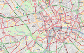
_p125_-_Sloane_Square_(map).jpg)
The station was opened on 24 December 1868 by the District Railway (DR, now the District line) when the company opened the first section of its line between South Kensington and Westminster stations.[4]
The construction of the station was complicated by the crossing of the site by the River Westbourne which ran through Hyde Park as the Serpentine Lake and was originally crossed by the Knight's Bridge at Knightsbridge. The River was carried above the platform in a large iron pipe suspended from girders. It remains in place today.[5]
The DR connected to the Metropolitan Railway (MR, later the Metropolitan line) at South Kensington and, although the two companies were rivals, each company operated its trains over the others tracks in a joint service known as the "Inner Circle".

On 1 February 1872, the DR opened a northbound branch from its station at Earl's Court to connect to the West London Extension Joint Railway (WLEJR, now the West London Line) to which it connected at Addison Road (now Kensington (Olympia)). From that date the "Outer Circle" service began running over the DR's tracks. The service was run by the North London Railway (NLR) from its terminus at Broad Street (now demolished) in the City of London via the North London Line to Willesden Junction, then the West London Line to Addison Road. Due to financial problems, the DR extended only one station further east, which is Mansion House[6][7] - the new eastern terminus of the DR.
From 1 August 1872, the "Middle Circle" service also began operations through Sloane Square running from Moorgate along the MR's tracks on the north side of the Inner Circle to Paddington then over the Hammersmith & City Railway (H&CR) track to Latimer Road then, via a now demolished link, to the West London Line to Addison Road and the DR to Mansion House. The service was operated jointly by the H&CR and the DR.
On 30 June 1900, the Middle Circle service was withdrawn between Earl's Court and Mansion House. On 31 December 1908 the Outer Circle service was also withdrawn.
In the late 1930s, the station building was rebuilt in the modern style and escalators were installed between the ticket hall and the platforms. The new station building did not last long as it was mostly destroyed during World War II. A German bomb that fell in November 1940 killed 37 and injured 79 passengers on a train[8] in the station and destroyed the ticket hall, escalators and the glazed roof over the tracks.
In 1949, the Metropolitan line operated Inner Circle route was given its own identity on the tube map as the Circle line. By 1951 the station had been rebuilt again in a similar style to the 1930s building. The arched glass roof was not replaced and the current station does not have the light open atmosphere of the original. The office building above the station entrance is a later addition.
Incidents and Accidents
On 5 April 1960, Peter Llewelyn Davies, one of the Llewelyn Davies boys who were the inspiration for the boy characters of J. M. Barrie's Peter Pan, or The Boy Who Wouldn't Grow Up, and who resented the public association with the character named after him, committed suicide by throwing himself under a train as it was pulling into the station.[9]
On 26 December 1973, a terrorist bomb exploded in the telephone kiosk in the booking office. No one was injured.[10]
The Station today
The station has ticket halls, escalators,[11] a Wifi service,[12] vending machines and a photo booth. It also has canopies over each platform.
Abandoned proposal
Sloane Square was going to be a stop on the long proposed Chelsea-Hackney line (a new London Underground line) but in the 2007 updating of safeguarding it was dropped. However it is planned to be re-introduced in the next safeguarding of the line. The Chelsea-Hackney line platforms would have been underground under the existing Circle and District lines tracks. Later, the proposal for both the building a station here was dropped and the London Underground was dropped once again in favour of a Crossrail line instead.[13]
Connections
London Bus routes 11, 19, 22, 137, 211, 319, 360, 452 and C1,[14] and night routes N11, N19, N22 and N137[15] serve the station.[16]
In literature
Sloane Square is one of two tube stations (the other being South Kensington) mentioned in the song "When you're lying awake" from the operetta Iolanthe by Gilbert and Sullivan.[17]
References
- 1 2 3 4 "Multi-year station entry-and-exit figures" (XLS). London Underground station passenger usage data. Transport for London. April 2016. Retrieved 3 May 2016.
- ↑ Transport for London (January 2016). Standard Tube Map (PDF) (Map). Not to scale. Transport for London. Archived (PDF) from the original on 3 January 2015.
- ↑ Google Maps - Sloane Square Tube Station
- ↑ Rose 2007.
- ↑ Jones, Ian. "69. The river over Sloane Square". 150 Great Things About the Underground. Retrieved 1 December 2012.
- ↑ Day & Reed 2008, pp. 25–26.
- ↑ Horne 2006, pp. 11–12.
- ↑
- ↑ Birkin, Andrew, J. M. Barrie and the Lost Boys, Yale University Press
- ↑ Terrorist Attacks on the London Underground
- ↑ "Avoiding Stairs Tube Guide" (PDF). Transport for London. December 2014. Retrieved 16 February 2015.
- ↑ Sloane Square Underground Station
- ↑ The Route - Crossrail 2
- ↑ "Buses from Sloane Square" (PDF). Transport for London. 26 September 2014. Retrieved 20 February 2015.
- ↑ "Night buses from Sloane Square" (PDF). Transport for London. January 2013. Retrieved 20 February 2015.
- ↑ Sloane Square Underground Station - Bus
- ↑ "When You're Lying Awake (lyrics)". Boise State University. Retrieved 4 February 2016.
External links
| Wikimedia Commons has media related to Sloane Square tube station. |
| Preceding station | Following station | |||
|---|---|---|---|---|
towards Edgware Road | Circle line | |||
| District line | towards Upminster |
|||
| Abandoned Development | ||||
| Preceding station | Following station | |||
towards Wimbledon | Chelsea-Hackney line | towards Epping |
||
| Stations |
| ||||||||||
|---|---|---|---|---|---|---|---|---|---|---|---|
| Rolling stock | |||||||||||
| History |
| ||||||||||
| See also | |||||||||||
| |||||||||||
| 2015 consultation route |
| ||||||||||||||||||||||||||||||||||||||||
|---|---|---|---|---|---|---|---|---|---|---|---|---|---|---|---|---|---|---|---|---|---|---|---|---|---|---|---|---|---|---|---|---|---|---|---|---|---|---|---|---|---|
| Previous proposals |
| ||||||||||||||||||||||||||||||||||||||||
| |||||||||||||||||||||||||||||||||||||||||