Slezská Harta Dam
| Slezská Harta Dam | |
|---|---|
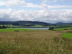 Slezská Harta Dam near Razová | |
| Coordinates | 49°53′25″N 17°34′53″E / 49.89028°N 17.58139°ECoordinates: 49°53′25″N 17°34′53″E / 49.89028°N 17.58139°E |
| Type | reservoir |
| Primary inflows | Moravice River |
| Primary outflows | Moravice River |
| Catchment area | 464.1 km² |
| Basin countries | Czech Republic |
| Max. length | 13 km |
| Max. width | 1.7 km |
| Surface area | 8.7 km² |
| Max. depth | 80 m |
| Water volume | 218 700 000 m³ |
Slezská Harta Dam (Czech: Vodní nádrž Slezská Harta) is a water reservoir and dam in the Nízký Jeseník mountain range, Moravian-Silesian Region, Czech Republic. The dam is built on upper course of the Moravice River. With the surface of 8.7 km² it is one of the largest reservoirs in the country. It was constructed in 1987-1998.
During the construction parts of six villages were demolished and subsequently flooded. The village of Karlovec was completely flooded and ceased to exist. Today only Saint John Nepomucen Church and several other abandoned buildings remain at the reservoir's shore.[1] Villages of Dlouhá Stráň, Nová Pláň, Razová, Roudno and Leskovec nad Moravicí were also partially flooded and are today located on the shore of the reservoir.
The dam is used mainly to generate electricity, supply drinking water to nearby towns and villages and to subdue floods on the Moravice River.
References
External links
| Wikimedia Commons has media related to Slezská Harta Reservoir. |
- (Czech) Entry at Odra Basin website