Slaidburn
| Slaidburn | |
 The 'Hark to Bounty', Slaidburn |
|
 Slaidburn |
|
| Population | 351 (2011 Census) |
|---|---|
| OS grid reference | SD715525 |
| Civil parish | Slaidburn |
| District | Ribble Valley |
| Shire county | Lancashire |
| Region | North West |
| Country | England |
| Sovereign state | United Kingdom |
| Post town | CLITHEROE |
| Postcode district | BB7 |
| Dialling code | 01200 |
| Police | Lancashire |
| Fire | Lancashire |
| Ambulance | North West |
| EU Parliament | North West England |
| UK Parliament | Ribble Valley |
|
|
Coordinates: 53°58′01″N 2°26′06″W / 53.967°N 2.435°W
Slaidburn is a village and civil parish within the Ribble Valley district of Lancashire, England. With a population in 2001 of just under 300, increasing to 351 at the 2011 Census,[1] the parish covers just over 5,000 acres of the Forest of Bowland.[2] Historically in the West Riding of Yorkshire, Slaidburn lies near the head of the River Hodder and Stocks Reservoir, both within the Forest of Bowland, an Area of Outstanding Natural Beauty. Farming is still a major employer, but the area attracts tourists; for walking in particular. The civil parish of Slaidburn shares a parish council with Easington, a rural parish to the north of Slaidburn.[3]
The parish church of St Andrew has a superb Jacobean screen and a fine Georgian pulpit. The brass band composer William Rimmer (1862–1936) composed the now-popular march, named Slaidburn after the village, for the Slaidburn Silver Band. A new village hall has opened to much fanfare and is being well used.[4] There is a local pub, the Hark to Bounty, which upstairs houses the ancient halmote or courthouse of the Manor of Slaidburn [5]
History
From early times, the Manor of Slaidburn formed part of the ancient Lordship of Bowland, being held in demesne from the second half of the 14th century.
The Lordship of Bowland comprised a royal forest and a liberty of ten manors spanning eight townships and four parishes and covered an area of almost 300 square miles (800 km2) on the historic borders of Lancashire and Yorkshire. The manors within the liberty were Slaidburn (Newton-in-Bowland, West Bradford, Grindleton), Knowlmere, Waddington, Easington, Bashall, Mitton, Withgill (Crook), Leagram (Bowland-with-Leagram), Hammerton and Dunnow (Battersby).
There was a major manorial reorganisation of Bowland in the second half of the 14th century, which may have been precipitated by a fall in population caused by the Black Death (1348–50) but was probably also a consequence of the absorption of Bowland into the Duchy of Lancaster. Among other changes, this saw Newton subsumed into the demesne of Slaidburn and the manorial caput shift from Grindleton to Slaidburn.[6]
Two of the Lord of Bowland's mesne manors - Battersby (Dunnow) and Knowlmere - fell within the bounds of the township of Newton but did not become part of the demesne of Slaidburn. See Newton-in-Bowland for further information.
According to a leading local historian, the historic Manor and Liberty of Slaidburn covered a wide area, not equivalent to the Slaidburn parish boundaries, but comprising the villages and town fields of Slaidburn and Newton-in-Bowland, including Ingbreak, a town field to the west of Slaidburn village; Raw Moor, part of the enclosed land of 1619 north of Slaidburn village in the Croasdale area; Brunghill Moor, Burn Moor and Dunsop, also enclosed in 1619 and near Back Lane and Burn Hill; Champion, also enclosed in 1619 and to the east of Slaidburn village; Woodhouse, to the north west of Slaidburn village; Youlstone Wood, also enclosed in 1619, and to the south of Newton village; and most of West Bradford and Grindleton villages and their town fields.[7]
Title to the Manor and Liberty of Slaidburn, West Bradford and Grindleton, including the township of Newton-in-Bowland, was bought by Tory MP, Ralph Assheton, later first Baron Clitheroe, in 1950.[8] In 1977, his second son, the Hon Nicholas Assheton, was granted title.[9] Since 2003, the Lord of the Manor and Liberty of Slaidburn has been Thomas Assheton, son of the Hon Nicholas Assheton and nephew of the second Baron Clitheroe.[10] Steward to the Manor of Slaidburn is Michael Parkinson. Parkinson, a land agent and chartered surveyor, also serves the Lord of Bowland as his Chief Steward of the Forest of Bowland.[11][12][13]
Governance
Along with Bowland Forest Low, Newton, Easington and Bolton-by-Bowland, the parish forms the Bowland, Newton and Slaidburn ward of Ribble Valley Borough Council. [14][15] The ward had a population of 1,243 in 2001,[16] rising to 1,325 in 2011.[17] The ward elects a single councillor, who currently is Joan Elms of the Conservative Party.[18]
Geography
The Roman road known as Watling Street, that runs from Manchester via Ribchester to Carlisle, passes in a NNE direction to the west of the village before turning NW on Low Fell. This section is also known as the Hornby Road.
The River Hodder flows through the parish, joined by Croasdale Brook on the eastern edge of the village.
To commemorate the 400th anniversary of the trials of the Pendle witches, a new long-distance walking route called the Lancashire Witches Walk has been created. Ten tercet waymarkers, designed by Stephen Raw, each inscribed with a verse of a poem by Carol Ann Duffy have been installed along the route, with the fifth located here.[19][20]
People
- Thomas Sanderson, (1793-1878) Farmer of Woodhouse, Slaidburn. He was also for many years Overseer of the Poor for the Slaidburn District and an Officer of HM Customs & Excise. In 1850, he and his wife Frances (née Bland - sister of the Rev Stephen Bland of St. Wilfrid's Church, Burnsall in Craven) and their children emigrated to Wisconsin, USA, on the SS Arctic where several of his sons rose to prominence - see below.[21]
- Robert B. Sanderson, (1825-1887) Wisconsin Senator who became one of the largest sheep breeders in Texas
- Thomas Sanderson (Wisconsin politician) (1827-1912) Farmer and State Legislator/Politician.
- Jonathan Sanderson, (1837-1914) He was known as the Pioneer Giant of Nebraska, standing six feet nine inches tall. Whilst he and his wife were still newcomers in Nebraska William F. Cody, (Buffalo Bill), and a scout stopped by and asked for shelter during a storm. They stayed two or three days playing cards and repairing and cleaning their guns. He was in the area as there had been some fighting on the little blue river about 20 miles south of the Sanderson home.[22]
- Joseph Sanderson, (1841-1914) Wisconsin farmer and State Legislator/Politician. He was very active in support of legislation beneficial to agricultural interests.
- Robert Parker (1731-1796) a prominent lawyer and attorney of Halifax, Yorkshire was born at Gamble Hole Farm in Newton in Bowland. He was baptised at Slaidburn Parish Church in March 1731 (1732 new style), the son of George Parker, a yeoman farmer. He is most famous for investigating and identifying the Cragg Vale Coiners who clipped gold and silver coins. He was also the attorney of choice for the owners of many of the large Yorkshire landed estates.[23]
- James Radley (1884–1959) one of the first English aviators, who was born at Dunnow Hall in Slaidburn.
- Tempest Slinger (1683-1728) a prominent lawyer and attorney of Gray's Inn and Lincoln's Inn, London and whose practice was the beginning of the law firm Farrer & Co, the Queen's solicitors. He was born at Dunnow Hall in Slaidburn in 1683, the son of Nicholas Slinger.
Ancient parish
The historic parish of Slaidburn comprised the townships of Bowland Forest High, Easington, Newton and Slaidburn itself.[24]
Church
The church of St Andrew was built in the Perpendicular style: the powerful stone tower contrasts with the long, low, rendered walls of the nave and aisles. There is a fine interior with a great variety of box and bench pews ranging in date from the 17th to the 19th century. The font-cover is Elizabethan, the screen Jacobean and the three-decker pulpit is Georgian.[25] The church is recorded in the National Heritage List for England as a designated Grade I listed building, having been listed in 1954.[26]
Media gallery
 Slaidburn Bridge
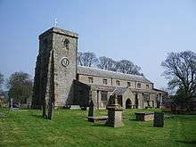 St Andrew's Church
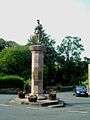 Slaidburn War Memorial
 Slaidburn from the north
 Slaidburn Village Hall
 Slaidburn Heritage Centre
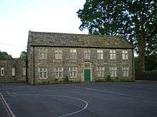 Brennand's Endowed School
See also
References
- ↑ "Civil Parish population 2011". Retrieved 23 January 2016.
- ↑ http://www.lancashireparishcouncils.gov.uk/documents/information/Parish_headcount.pdf
- ↑ "Parish Council Details: Slaidburn and Easington Parish Council". Lancashire Parish Portal. Lancashire County Council. Retrieved 2008-09-20.
- ↑ http://www.slaidburnvillagehall.com
- ↑ http://www.harktobounty.co.uk
- ↑ C J. Spencer and S.W. Jolly, 'Bowland: the rise and decline, abandonment and revival of a medieval lordship' The Escutcheon: Journal of the Cambridge University Heraldic & Genealogical Society 15, 2010 Download
- ↑ CJ Spencer Manor of Slaidburn Court Rolls
- ↑ HM Land Registry, 22 June 1950
- ↑ HM Land Registry, 26 August 1977
- ↑ HM Land Registry, LA937696, 1 June 2003; ownership of common land is registered under LA955806, LA955807, LA955808, LA955809
- ↑ "Michael Parkinson, Esq Authorised Biography – Debrett's People of Today". www.debretts.com. Retrieved 2011-04-05.
- ↑ Clitheroe Man is Chief Steward of All He Surveys, Lancashire Telegraph, 1 June 2011: http://www.lancashiretelegraph.co.uk/news/9059535.Clitheroe_man_is_chief_steward_of_all_he_surveys/
- ↑ "Lord of the Fells, Guardian of History" (PDF). Rural Life. November 2014.
- ↑ "Bowland, Newton and Slaidburn". MARIO. Lancashire County Council. Retrieved 25 March 2016.
- ↑ "Bowland, Newton and Slaidburn". Ordnance Survey Linked Data Platform. Ordnance Survey. Retrieved 25 March 2016.
- ↑ "Bowland, Newton and Slaidburn ward population 2001". Neighbourhood Statistics. Office for National Statistics. Retrieved 25 March 2016.
- ↑ "Bowland, Newton and Slaidburn ward population 2011". Neighbourhood Statistics. Office for National Statistics. Retrieved 25 March 2016.
- ↑ "Councillors by Ward: Bowland, Newton and Slaidburn". Ribble Valley Borough Council. Retrieved 23 March 2016.
- ↑ ""Tercet" waymarkers". Lancashire Witches 400. Green Close Studios. Retrieved 29 November 2015.
- ↑ "Lancashire Witches Walk: Day 4" (PDF). Forest of Bowland Area of Outstanding Natural Beauty. Lancashire County Council. Retrieved 29 November 2015.
- ↑ All of the material about the Sanderson family, and more, can be found in: The Garden Spot of the World - Sanderson Family History compiled by Edith Hurlbutt Sanderson 1971
- ↑ A Pioneer Life: The Story of Jonathan and Rebecca McCloughan Sanderson. Privately Published, May 1981.
- ↑ 'Robert Parker, Attorney' Parts I and II, by C D Webster MA, published by the Halifax Antiquarian Society, 1966 and 1967
- ↑ "GENUKI: Slaidburn". Extracts from Lewis's Topographical Dictionary of England 1835. Retrieved 2011-04-30.
- ↑ Betjeman, John, ed. (1968) Collins Pocket Guide to English Parish Churches: the North. London: Collins; p. 349
- ↑ Historic England. "Church of St. Andrew (1163738)". National Heritage List for England. Retrieved 30 April 2011.
External links
| Wikimedia Commons has media related to Slaidburn. |
- Slaidburn Conservation Area Appraisal
- Bell Sykes Meadow SSSI
- Langcliff Cross Meadow SSSI
- Myttons Meadow SSSI
- Standridge Farm Pasture SSSI