Skjervøy
| Skjervøy kommune Skiervvá suohkan Kieruan komuuni | |||
|---|---|---|---|
| Municipality | |||
|
Village of Årviksand | |||
| |||
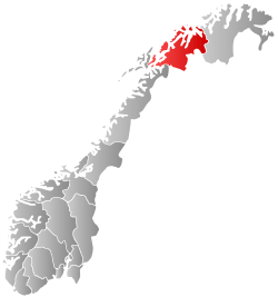
 Skjervøy within Troms | |||
| Coordinates: 70°5′7″N 20°39′34″E / 70.08528°N 20.65944°ECoordinates: 70°5′7″N 20°39′34″E / 70.08528°N 20.65944°E | |||
| Country | Norway | ||
| County | Troms | ||
| District | Nord-Troms | ||
| Administrative centre | Skjervøy | ||
| Government | |||
| • Mayor (2015) | Ørjan Albrigtsen (Coalition between KrF and Kp) | ||
| Area | |||
| • Total | 473.00 km2 (182.63 sq mi) | ||
| • Land | 464.27 km2 (179.26 sq mi) | ||
| • Water | 8.73 km2 (3.37 sq mi) | ||
| Area rank | 210 in Norway | ||
| Population (2012) | |||
| • Total | 2,880 | ||
| • Rank | 274 in Norway | ||
| • Density | 6.2/km2 (16/sq mi) | ||
| • Change (10 years) | -4.4 % | ||
| Demonym(s) | Skjervøyværing[1] | ||
| Time zone | CET (UTC+1) | ||
| • Summer (DST) | CEST (UTC+2) | ||
| ISO 3166 code | NO-1941 | ||
| Official language form | Bokmål | ||
| Website |
www | ||
|
| |||


Skjervøy (Northern Sami: Skiervvá suohkan; Kven: Kieruan komuuni) is a municipality in Troms county, Norway. The administrative centre of the municipality is the village of Skjervøy on the island of Skjervøya, where most of the inhabitants live. The main industries are fishing and shipbuilding.
General information

The municipality of Skjervøe (later spelled Skjervøy) was established on 1 January 1838 (see formannskapsdistrikt). In 1863, the southeastern (inland) part of the municipality (population: 1,677) was separated to form the new municipality of Kvænangen. This left 2,785 people in Skjervøy. Then on 1 January 1886 the southern part of the municipality (population: 1,057) was separated from Skjervøy to form the new municipality of Nordreisa. This left 2,096 inhabitants in Skjervøy.
On 1 January 1890, the Trætten and Loppevolden farms (population: 32) were transferred from Skjervøy to Nordreisa. On 1 January 1965 the Meilands area (population: 12) was transferred to Kvænangen. On 1 January 1972 the parts of Skjervøy lying on the mainland (population: 1,556) were transferred from Skjervøy to Nordreisa, and the uninhabited Mannskarvik farm was transferred to Kvænangen. Then on 1 January 1982 the southern part of Uløya (population: 128) was transferred from Skjervøy to Nordreisa.[2]
Name
The municipality (originally the parish) is named after the small island of Skjervøya (Old Norse: Skerføy), since the first church (Skjervøy Church) was built there. The first element is skerf which means "rocky ground" and the last element is øy which means "island". Before 1909 the name was written Skjervø, and earlier it was spelled Skjervøe.[3]
Coat-of-arms
The coat-of-arms is from modern times. It was granted on 27 March 1987. The arms show the black head of a cormorant on a silver background, partly canting since skarf means cormorant. The cormorant also symbolizes the coastal municipality, which, as the bird, is dependent on fishing for its living. The cormorant is also a common bird in the area.[4]
Churches
The Church of Norway has one parish (sokn) within the municipality of Skjervøy. It is part of the Nord-Troms deanery in the Diocese of Nord-Hålogaland.
| Parish (Sokn) | Church Name | Location of the Church | Year Built |
|---|---|---|---|
| Skjervøy | Arnøy Church | Arnøyhamn | 1978 |
| Skjervøy Church | Skjervøy | 1728 |
History
Skjervøy Church dates back to 1728 and it is the oldest wooden church in Troms county. The village of Maursund is an old trading post with well-preserved 19th-century houses.
Government
All municipalities in Norway, including Skjervøy, are responsible for primary education (through 10th grade), outpatient health services, senior citizen services, unemployment and other social services, zoning, economic development, and municipal roads. The municipality is governed by a municipal council of elected representatives, which in turn elect a mayor.
Municipal council
The municipal council (Kommunestyre) of Skjervøy is made up of 19 representatives that are elected to every four years. Currently, the party breakdown is as follows:[5]
| Party Name | Name in Norwegian | Number of representatives | |
|---|---|---|---|
| Labour Party | Arbeiderpartiet | 4 | |
| Progress Party | Fremskrittspartiet | 3 | |
| Conservative Party | Høyre | 1 | |
| Centre Party | Senterpartiet | 4 | |
| Socialist Left Party | Sosialistisk Venstreparti | 2 | |
| Local Lists | Lokale lister | 5 | |
| Total number of members: | 19 | ||
Geography
The island municipality is surrounded by the Norwegian Sea to the north, Ullsfjorden to the west, Lyngenfjorden to the southwest, Reisafjorden to the southeast, and Kvænangen fjord to the east. The municipality consists of several islands, the major one being Arnøya, with the villages of Årviksand, Akkarvik, and Arnøyhamn. Most people, however, live on the relatively small island of Skjervøya, where more than 2,316 people live in the central village of Skjervøy with its sheltered harbour.[6] The other islands include Haukøya, Kågen, Laukøya, Vorterøya, and the northern half of Uløya. Kågen and Skjervøya are connected by the Skjervøy Bridge. Kågen is connected to the mainland by the Maursund Tunnel.
Climate
| Climate data for Skjervøy | |||||||||||||
|---|---|---|---|---|---|---|---|---|---|---|---|---|---|
| Month | Jan | Feb | Mar | Apr | May | Jun | Jul | Aug | Sep | Oct | Nov | Dec | Year |
| Daily mean °C (°F) | −3.5 (25.7) |
−3.5 (25.7) |
−2.3 (27.9) |
0.7 (33.3) |
4.9 (40.8) |
8.8 (47.8) |
11.8 (53.2) |
11.1 (52) |
7.5 (45.5) |
3.4 (38.1) |
−0.5 (31.1) |
−2.5 (27.5) |
3.0 (37.4) |
| Average precipitation mm (inches) | 76 (2.99) |
75 (2.95) |
59 (2.32) |
51 (2.01) |
42 (1.65) |
52 (2.05) |
57 (2.24) |
73 (2.87) |
69 (2.72) |
107 (4.21) |
86 (3.39) |
83 (3.27) |
830 (32.68) |
| Source: Norwegian Meteorological Institute[7] | |||||||||||||
Transportation
The Hurtigruten (coastal express ferry) stops at Skjervøy. There is also a speedboat connection with Tromsø. The undersea Maursund Tunnel connects this island with the mainland. There is also a ferry connection to Arnøya and Laukøya. Sørkjosen Airport offers flights to Tromsø and several destinations in Finnmark.
Media gallery
 Part of Skjervøy village
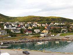 Part of Skjervøy village
 Old photo of Skjervøy Church
References
- ↑ "Navn på steder og personer: Innbyggjarnamn" (in Norwegian). Språkrådet. Retrieved 2015-12-01.
- ↑ Jukvam, Dag (1999). "Historisk oversikt over endringer i kommune- og fylkesinndelingen" (PDF) (in Norwegian). Statistisk sentralbyrå.
- ↑ Rygh, Oluf (1911). Norske gaardnavne: Troms amt (in Norwegian) (17 ed.). Kristiania, Norge: W. C. Fabritius & sønners bogtrikkeri. p. 176.
- ↑ Norske Kommunevåpen (1990). "Nye kommunevåbener i Norden". Retrieved 2008-12-07.
- ↑ "Table: 04813: Members of the local councils, by party/electoral list at the Municipal Council election (M)" (in Norwegian). Statistics Norway. 2015.
- ↑ Statistisk sentralbyrå (1 January 2012). "Urban settlements. Population and area, by municipality.".
- ↑ "eKlima Web Portal". Norwegian Meteorological Institute.
External links
- 41 kg cod caught on fishing rod April 2010 (with pictures) (Norwegian)
 Troms travel guide from Wikivoyage
 Media related to Skjervøy at Wikimedia Commons
 The dictionary definition of skjervøy at Wiktionary