Skejby
| Skejby | |
|---|---|
| Neighborhood | |
|
The old Skejby Church | |
 Skejby | |
| Coordinates: DK 56°11′26″N 10°10′41″E / 56.190680°N 10.178177°E | |
| Country | Kingdom of Denmark |
| Regions of Denmark | Central Denmark Region |
| Municipality | Aarhus Municipality |
| District | Aarhus N |
| Postal code | 8200 |
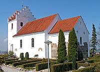
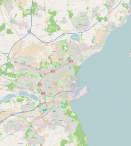
Skejby is a neighbourhood and former village in Aarhus, Denmark. The village was originally situated in the countryside north of Aarhus, overlooking the flat Egå Valley, but urban development has lately engulfed it, creating a new suburban neighbourhood by the same name. The old village is still distinctly visible, surrounding the old white village church.
Archaeological excavations have revealed, that the area has been settled since the early Iron Ages (c. 500 BC), but finds from the Stone Age has also been unearthed.[1][2] Søften and Lisbjerg north of Skejby, are important archaeological sites.
The neighbourhood of Skejby
The neighbourhood comprise a large business park, an industrial park, and several major institutions for education and business. Residential areas forms a large part of Skejby east of the expressway of Randersvej, while the old village is the only residential area west of the expressway, with the exception of a few new apartmentblocks near nature site of Vestereng.
Business Park Skejby stretches south from the village of Skejby towards Aarhus and continues into the neighbourhood of Christiansbjerg. In Skejby, it contains offices and business headquarters for companies such as Vestas, Rambøll, IBM, TDC Hosting and UNI-C and the Agro Food Park, with a focus on agriculture and foodstuff.[3] The headquarters of INCUBA Science Park, the educational institution of Professionshøjskolen VIA University College and the large regional Aarhus University Hospital is also located here.
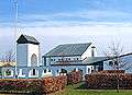
East of the expressway of Randersvej, in a low-rise residential area, is the mall of Skejby Centret and the headquarters of the television company department TV 2/Østjylland. North of here is a lightweight industrial park stretching eastward into the neighbourhood of Vejlby. The industrial park comprise large store departments of ILVA, IKEA and Silvan Byggemarked and a number of mixed industries, offices and warehouse facilities. The woodland of Mollerup Skov in the east, connects with the nature site of Egå Engsø.
Gallery
 The modern church of Skelager Kirke.
 Skejby Centret
_4.jpg) From Mollerup Skov.
From Mollerup Skov.
References
- ↑ "Prehistory is right here" (in Danish). DNU. December 7, 2010. Retrieved March 12, 2014.
- ↑ Moesgård Museum (2011): Craftsman of the Stone Age "Udgravning ved Skejby Universitetshospital", official archaeological blog from the excavations. Pictures and maps. (Danish)
- ↑ "Business Park Skejby". Retrieved 31 March 2016.
| Wikimedia Commons has media related to Skejby. |
Coordinates: 56°11′26″N 10°10′41″E / 56.190680°N 10.178177°E