Siu Sai Wan
| Siu Sai Wan | |||||||||||
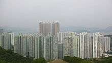
 Aerial View of Siu Sai Wan and Cape Collinson | |||||||||||
| Traditional Chinese | 小西灣 | ||||||||||
|---|---|---|---|---|---|---|---|---|---|---|---|
| Literal meaning | "small west bay" | ||||||||||
| |||||||||||


Siu Sai Wan (Chinese: 小西灣) is a newly developed residential area in the northeastern part of Hong Kong Island in Hong Kong. It is located in the eastern part of Chai Wan, and is administratively under the Eastern District. The population was 59,729 in June 2011.[1]
Location
The current perimeter of Siu Sai Wan includes the rest of Chai Wan east of Wing Tai Road. Prior to reclamation, Siu Sai Wan was a small bay east of Chai Wan. Chai Wan was once known as Sai Wan (西灣, sai1 waan1, Xīwān, West Bay), and the small bay as Siu Chai Wan (小柴灣, siu2 caai4 waan1, Xiǎocháiwān, Lesser Chai Wan) or Chai Wan Tsai (柴灣仔, caai4 waan1 zai2, Cháiwānzǎi, Child of Chai Wan), and over time the names combined into the current name Siu Sai Wan.
History
Siu Sai Wan was originally an intelligence gathering centre for the United Kingdom. In 1947, Britain, the United States, Australia, Canada and New Zealand signed an agreement to jointly pursue the gathering of intelligence. The British Armed Forces then set up an intelligence gathering centre in Siu Sai Wan, one of the largest in the Far East, to monitor wireless communications from the then Republic of China (ROC), present-day China (PRC). In 1985, shortly after the handover of Hong Kong to the PRC was agreed, the centre was dismantled.
At the same time, along with the development of the Mass Transit Railway, the resettlement estates in Chai Wan were to be demolished. To accommodate residents from these estates and from the expanding urban population, the government decided to develop Siu Sai Wan. At that time the name Siu Sai Wan was deemed "indecent" by the Government, who suggested to name the area "Siu Chai Wan" instead. This didn't sit well with local residents, and as a result when the Siu Sai Wan Estate was built a few years later, the name Siu Sai Wan was returned to the area. Nevertheless, taxi drivers are known to use a similar-sounding profane term when they refer to the area.
Siu Sai Wan faces Tathong Channel, an entrance to the Victoria Harbour, and promotes beautiful scenery. The government has built Home Ownership Scheme housing such as Harmony Garden.
Housing


Schools
A number of schools including both primary and secondary schools can be found in Siu Sai Wan.
- Secondary schools:
- Fukien Secondary School (Siu Sai Wan)
- Hon Wah College
- Lingnan Hang Yee Memorial Secondary School
- The Chinese Foundation Secondary School (CFSS)
- The Methodist Church Hong Kong Wesley College
- Primary schools:
- Pui Kiu Primary School
- Tung Wah Group of Hospitals Lee Chi Hung Memorial Primary School (Chai Wan) (Closed down on 31 August 2011)
- Kindergartens:
- Cannan Kindergarten (Siu Sai Wan)
- Gar Lam Anglo-Chinese Kindergarten (Siu Sai Wan)
Social amenities


- Siu Sai Wan Sports Ground
- Siu Sai Wan Promenade
- Siu Sai Wan Complex
Transport
With the Island Resort now constructed, the population of Siu Sai Wan has been steadily increasing, at present, both First Bus and Citybus extended routes end at Chai Wan (East) and Siu Sai Wan Estate and Island Resort.
The government suggested to the MTR Corporation (MTRC) in 2001 that they should consider extending the Island Line to Siu Sai Wan from Chai Wan. In June 2005, the MTRC revealed that they had started planning for the extension.
Main roads
- Siu Sai Wan Road
Public transportation
There's currently no MTR service in Siu Sai Wan.
- Buses
- New World First Bus:8P, 81S, 82, 82M, 82S, 82X, 88X, N8P
- Citybus: 8S, 8X, 19, 85, 85P, 314, 788, 789, A12, N8X
- Cross-harbour routes: 106, 106P, 118, 118P, 606, 606X, 682, 694, 802, N118
- Minibuses
- Green Public Light Buses
- 44M, 47M, 61, 62, 62A
- Green Public Light Buses
Only full-time serviced routes are listed above.
References
- ↑ "LCQ11: Study on the construction of the MTR Siu Sai Wan extension". Hong Kong Government. 7 November 2012.
| Wikimedia Commons has media related to Siu Sai Wan. |
 |
(Victoria Harbour) | | ||
| Wan Chai District | |
Tathong Channel | ||
| ||||
| | ||||
| Southern District |
Coordinates: 22°15′42″N 114°14′57″E / 22.2617°N 114.2492°E