Sirolo
| Sirolo | |
|---|---|
| Comune | |
| Comune di Sirolo | |
 Sirolo Location of Sirolo in Italy | |
| Coordinates: 43°32′N 13°37′E / 43.533°N 13.617°ECoordinates: 43°32′N 13°37′E / 43.533°N 13.617°E | |
| Country | Italy |
| Region | Marche |
| Province / Metropolitan city | Ancona (AN) |
| Frazioni | Coppo, Fonte d'Olio, Madonnina, San Lorenzo |
| Area | |
| • Total | 16.68 km2 (6.44 sq mi) |
| Elevation | 125 m (410 ft) |
| Population (February 2009) | |
| • Total | 3,747 |
| • Density | 220/km2 (580/sq mi) |
| Time zone | CET (UTC+1) |
| • Summer (DST) | CEST (UTC+2) |
| Postal code | 60020 |
| Dialing code | 071 |
| Patron saint | Saint Nicholas |
| Saint day | 9 May |
| Website | Official website |
Sirolo is a comune (municipality) in the Province of Ancona in the Italian region of Marche. As of 28 February 2009 it had a population of 3,747 inhabitants and an area of 16.68 square kilometres (6.44 sq mi).
The town is situated near Monte Conero and in medieval times it was a castle which belonged to the Conti Cortesi family. It is a tourist destination, especially in summer times and it has been awarded one of the eleven blue flags in the region of Marche. It features a restored medieval town centre, which culminates with a particular little square with view on the sea and on the Monte Conero. It also regularly hosts Miss Italia which provides much entertainment. Being a relatively popular tourist destination, it has many restaurants and bars. From the main piazza there is a 10-minute walk to the beautiful beach.
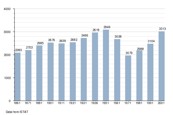
Demographic evolution