Sipaliwini District
Coordinates: 3°46′37″N 56°01′40″W / 3.77694°N 56.02778°W
| Sipaliwini | |
|---|---|
| District | |
 | |
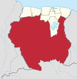 Map of Suriname showing Sipaliwini district | |
| Coordinates: 3°47′N 56°02′W / 3.783°N 56.033°W | |
| Country |
|
| Area | |
| • Total | 130,567 km2 (50,412 sq mi) |
| Population (2012 census) | |
| • Total | 37,065 |
| • Density | 0.28/km2 (0.74/sq mi) |
| Time zone | ART (UTC-3) |
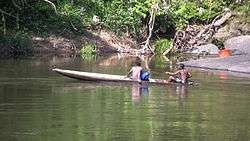
Sipaliwini is the largest district of Suriname, located in the south. Sipaliwini does not have a regional capital as it is directly administered by the national government in Paramaribo. The main villages in the district are Apetina, Apoera, Bakhuys, Bitagron, Pokigron, Kajana, Kamp 52, Pelelu Tepu, Cottica, Anapaike, Benzdorp, Kwamalasamutu, Nieuw Jacobkondre, Aurora, Botopasi, Goddo, Djumu and Pontoetoe.
Sipaliwini has a population of 37,065 and an area of 130,567 km². The district is larger than the other 9 districts of Suriname put together; however, most of the Sipaliwini is unused (it was specifically stated when the district was formed that it would encompass the unused land in Suriname's south) except for the north and the west.
It is thought by archaeologists that hunter-gatherers lived in what is today Sipaliwini district during the Paleolithic period.
The region was largely left alone during the colonial period, as the Dutch that controlled Suriname were fearful of the Portuguese in Brazil, and it was not until the 20th century that development projects began.
Sipaliwini district has seen occasional fighting between Guyanese and Surinamese troops over border disputes in the south-west Tigri Area of the Coeroeni resort.
Resorts
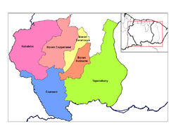
Sipaliwini is divided into 6 resorts (ressorten):
| Brokopondo District |  | |
|---|---|---|
| Commewijne District | ||
| Coronie District | ||
| Marowijne District | ||
| Nickerie District | ||
| Para District | ||
| Paramaribo District | ||
| Saramacca District | ||
| Sipaliwini District | ||
| Wanica District | ||