Sint-Katelijne-Waver
| Sint-Katelijne-Waver | |||
|---|---|---|---|
| Municipality | |||
 | |||
| |||
 Sint-Katelijne-Waver Location in Belgium | |||
|
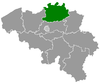
Location of Sint-Katelijne-Waver in the province of Antwerp  | |||
| Coordinates: 51°04′N 04°32′E / 51.067°N 4.533°ECoordinates: 51°04′N 04°32′E / 51.067°N 4.533°E | |||
| Country | Belgium | ||
| Community | Flemish Community | ||
| Region | Flemish Region | ||
| Province | Antwerp | ||
| Arrondissement | Mechelen | ||
| Government | |||
| • Mayor | Kristof Sels (NVA) | ||
| • Governing party/ies | CD&V/N-VA, independent | ||
| Area | |||
| • Total | 36.12 km2 (13.95 sq mi) | ||
| Population (1 January 2016)[1] | |||
| • Total | 20,609 | ||
| • Density | 570/km2 (1,500/sq mi) | ||
| Postal codes | 2860, 2861 | ||
| Area codes | 015, 03 | ||
| Website | www.sint-katelijne-waver.be | ||

Sint-Katelijne-Waver (Dutch pronunciation: [sɪnt kɑtəˌlɛi̯nə ˈʋaːvər], old spelling: Kathelijne-Waver, French Wavre-Sainte-Catherine) is a municipality located in the Belgian province of Antwerp. The municipality comprises the towns of Onze-Lieve-Vrouw-Waver and Sint-Katelijne-Waver proper. On January 1, 2006 Sint-Katelijne-Waver had a total population of 19,577. The total area is 36.12 km² which gives a population density of 542 inhabitants per km². Roosendael, a ruined relic of a cistercian abbey is situated here and host today a youth and touristic centre with pleasant walkways.
Economic activities
Sint-Katelijne-Waver is a centre for market gardening and hosts a lot of greenhouses. The Mechelse Veilingen [2] in Sint-Katelijne-Waver is the largest co-operative vegetable auction in Europe.
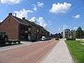
Pictures
 Leliestraat
 Town hall
 Church
 Town centre
References
External links
 Media related to Sint-Katelijne-Waver at Wikimedia Commons
- Official website - Available only in Dutch
 |
Rumst | Duffel, Lier | | |
| Mechelen | |
Putte | ||
| ||||
| | ||||
| Bonheiden |