Simeto
| Simeto | |
|---|---|
 | |
| Country | Italy |
| Basin | |
| Main source |
Nebrodi Mountains about 1,700 m (5,600 ft) |
| River mouth | Ionian Sea |
| Basin size | 4,186 km2 (1,616 sq mi) |
| Physical characteristics | |
| Length | 113 km (70 mi) |
| Discharge |
|
The Simeto (Italian pronunciation: [siˈmɛːto]; Sicilian: Simetu Latin: Symaethus; Greek Σύμαιθος) is a 113-kilometre (70 mi) long river in Sicily, southern Italy. It is the second longest river on the island after the Salso (also known as Southern Imera), but the most important in terms of watershed and for the population of the nearby areas. All of its course is included in the province of Catania.
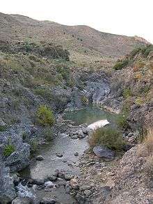
Its source is located near Bronte, from the union of several streams of the Nebrodi Mountains. After receiving its first affluence, the Troina, the river starts running southwards into a spectacular canyon of lava from eruptions of Mount Etna. Near Adrano, Simeto constitutes the boundary between the province of Catania and that of Enna, and receives the Salso,[1] then flows near Paternò.
Simeto's final course is slower and twisting, being all included in the plain of Catania; its last confluences are with the Dittaino and the Gornalunga, before flowing into the Ionian Sea south to the metropolitan area of Catania.
Notes
- ↑ Not to be confused with the largest Salso River of western Sicily.
Coordinates: 37°24′N 15°06′E / 37.400°N 15.100°E