Sils im Domleschg
| Sils im Domleschg | ||
|---|---|---|
|
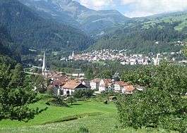
Sils im Domleschg (foreground) | ||
| ||
 Sils im Domleschg | ||
|
Location of Sils im Domleschg  | ||
| Coordinates: 46°42′N 9°27′E / 46.700°N 9.450°ECoordinates: 46°42′N 9°27′E / 46.700°N 9.450°E | ||
| Country | Switzerland | |
| Canton | Graubünden | |
| District | Hinterrhein | |
| Government | ||
| • Mayor | Rudolf Hans Künzler | |
| Area[1] | ||
| • Total | 9.32 km2 (3.60 sq mi) | |
| Elevation | 633 m (2,077 ft) | |
| Population (Dec 2015[2]) | ||
| • Total | 927 | |
| • Density | 99/km2 (260/sq mi) | |
| Postal code | 7411 | |
| SFOS number | 3640 | |
| Surrounded by | Fürstenau, Mutten, Rongellen, Scharans, Thusis, Vaz/Obervaz, Zillis-Reischen | |
| Website |
www SFSO statistics | |

Sils im Domleschg (Romansh: Seglias) is a municipality in the district of Hinterrhein in the Swiss canton of Graubünden.
History
Sils im Domleschg is first mentioned in 1149 as de Sillas.[3]
Geography

Sils im Domleschg has an area, as of 2006, of 9.3 km2 (3.6 sq mi). Of this area, 14.9% is used for agricultural purposes, while 68.6% is forested. Of the rest of the land, 8% is settled (buildings or roads) and the remainder (8.5%) is non-productive (rivers, glaciers or mountains).[4]
The municipality is located in the Domleschg sub-district, of the Hinterrhein district. It is a linear village between the Albula and Hinterrhein rivers. It consists of the village of Sils im Domleschg and the hamlets of Freihof, Campi and Albula.
Demographics
Sils im Domleschg has a population (as of 31 December 2015) of 927.[2] As of 2008, 11.6% of the population was made up of foreign nationals. Over the last 10 years the population has decreased at a rate of -2.3%.[4]
As of 2000, the gender distribution of the population was 48.5% male and 51.5% female.[5] The age distribution, as of 2000, in Sils im Domleschg is; 220 people or 10.4% of the population are between 0 and 9 years old. 106 people or 5.0% are 10 to 14, and 139 people or 6.6% are 15 to 19. Of the adult population, 248 people or 11.7% of the population are between 20 and 29 years old. 334 people or 15.7% are 30 to 39, 306 people or 14.4% are 40 to 49, and 278 people or 13.1% are 50 to 59. The senior population distribution is 201 people or 9.5% of the population are between 60 and 69 years old, 154 people or 7.3% are 70 to 79, there are 115 people or 5.4% who are 80 to 89, and there are 21 people or 1.0% who are 90 to 99.[6]
In the 2007 federal election the most popular party was the SVP which received 43.4% of the vote. The next three most popular parties were the SPS (27.4%), the FDP (19.7%) and the CVP (8.1%).[4]
In Sils im Domleschg about 73.3% of the population (between age 25-64) have completed either non-mandatory upper secondary education or additional higher education (either university or a Fachhochschule).[4]
Sils im Domleschg has an unemployment rate of 1.55%. As of 2005, there were 22 people employed in the primary economic sector and about 9 businesses involved in this sector. 209 people are employed in the secondary sector and there are 26 businesses in this sector. 70 people are employed in the tertiary sector, with 27 businesses in this sector.[4]

From the 2000 census, 700 or 33.0% are Roman Catholic, while 1,176 or 55.4% belonged to the Swiss Reformed Church. Of the rest of the population, there are 43 individuals (or about 2.03% of the population) who belong to the Orthodox Church, and there are 13 individuals (or about 0.61% of the population) who belong to another Christian church. There are 21 (or about 0.99% of the population) who are Islamic. There are 1 individuals (or about 0.05% of the population) who belong to another church (not listed on the census), 97 (or about 4.57% of the population) belong to no church, are agnostic or atheist, and 71 individuals (or about 3.35% of the population) did not answer the question.[6]
The historical population is given in the following table:[3][5]
| year | population |
|---|---|
| 1803 | 277 |
| 1850 | 295 |
| 1900 | 621 |
| 1910 | 541 |
| 1950 | 590 |
| 1960 | 737 |
| 1970 | 762 |
| 1980 | 826 |
| 1990 | 794 |
| 2000 | 880 |
Languages
Most of the population (as of 2000) speaks German (86.8%), with Serbo-Croatian being second most common ( 3.3%) and Italian being third ( 2.8%).[4]
| Languages in Sils im Domleschg | ||||||
| Languages | Census 1980 | Census 1990 | Census 2000 | |||
| Number | Percent | Number | Percent | Number | Percent | |
| German | 612 | 74.09% | 646 | 81.36% | 764 | 86.82% |
| Romansh | 56 | 6.78% | 34 | 4.28% | 14 | 1.59% |
| Italian | 104 | 12.59% | 60 | 7.56% | 25 | 2.84% |
| Population | 826 | 100% | 794 | 100% | 880 | 100% |
Heritage sites of national significance
Ehrenfels Castle, Carschenna (pre-historic petroglyphs), the ruins of Hohenrätien Castle and the ruins of Campell or Campi Castle are listed as Swiss heritage sites of national significance.[7]
 Carschenna petroglyphs
 Burg Ehrenfels
 Ruins of Hohenrätien
 Ruine Campi (or Campell)
References
- ↑ Arealstatistik Standard - Gemeindedaten nach 4 Hauptbereichen
- 1 2 Swiss Federal Statistical Office - STAT-TAB, online database – Ständige und nichtständige Wohnbevölkerung nach institutionellen Gliederungen, Geburtsort und Staatsangehörigkeit (German) accessed 30 August 2016
- 1 2 Sils im Domleschg in German, French and Italian in the online Historical Dictionary of Switzerland.
- 1 2 3 4 5 6 Swiss Federal Statistical Office accessed 05-Oct-2009
- 1 2 Graubunden in Numbers (German) accessed 21 September 2009
- 1 2 Graubunden Population Statistics (German) accessed 21 September 2009
- ↑ Swiss inventory of cultural property of national and regional significance 21.11.2008 version, (German) accessed 05-Oct-2009
| Wikimedia Commons has media related to Sils im Domleschg. |