Sillees River
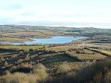
The Sillees River (Irish: Abhainn na Sailchis meaning "the sally kesh river") is located in south west County Fermanagh. Its origins lie in Lough Ahork, which is located in Lough Navar Forest (Coill Loch na bhFear). From here it continues through Correl Glen, Derrygonnelly and the Boho countryside passing through both Carran and Ross Loughs where it ends in Lower Lough Erne.[1][2]
There are a few tributary streams and rivers that flow into the Sillees river, amongst them, the Boho River, the Screenagh which emerges from the Arch cave and the Reyfad stream which enters Pollytullybrack of the Reyfad cave system.[3]
Folk tales associated with the river
The river is famous for the curse which was given by St Faber when she changed its direction, making the river bad for fishing and good for drowning.[4]
In another tale of the river, there is a Highwayman known as Black Francis Corrigan, who leaps the Sillees in a single bound with his horse after a famous robbery.[5]
Geological and palaeontological interest
The Sillees River has the distinction of having a species of brachiopod named after it, namely Rugosochonetes silleesi.[6] Indeed, some 56 species of early Carboniferous brachiopods alone were discovered in this area as well as 69 species of bryozoans.[6][7]
References
- ↑ "The Sillees Valley Geodiversity Profile". Northern Ireland Environment Agency. Retrieved 2009-05-03.
- ↑ "Lough Navar Forest". Department of Agriculture and Rural Development, Forest Service. Retrieved 2009-05-03.
- ↑ "Earth Science Conservation Review". National Museums Northern Ireland.
- ↑ Glassie, Henry (1998). Irish Folk History: Tales from the North. University of Pennsylvania Press. p. 176. ISBN 9780812211238.
- ↑ Henry H. Glassie, Doug Boyd (2006). The stars of Ballymenone. Published by Indiana University Press. p. 574. ISBN 9780253347176.
- 1 2 Simms, Michael J. "Carrick Lough, Bunnahone Lough and the Sillees River". Northern Ireland Environment Agency. Retrieved 2009-05-03.
- ↑ Brunton, C.H.C. (1968). "Silicified Brachiopods from the Visean of County Fermanagh (II)". Bulletin of the British Museum. British Museum of Natural History. Geology Volume 16 (i).
| Wikimedia Commons has media related to Sillees River. |
Coordinates: 54°20′N 7°38′W / 54.333°N 7.633°W