Siliguri Corridor
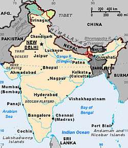
The Siliguri Corridor, or Chicken's Neck, is a narrow stretch of land, located in the Indian state of West Bengal, that connects India's northeastern states to the rest of India, with the countries of Nepal and Bangladesh lying on either side of the corridor. The kingdom of Bhutan lies on the northern side of the corridor.
The city of Siliguri, in the state of West Bengal, is the major settlement in this area and the central node that connects Bhutan, Nepal, Bangladesh, Sikkim, Darjeeling hills, Northeast India and the rest of India.
History
The Siliguri Corridor was created in 1947 after the partition of Bengal between India and Pakistan (former state of East Bengal, now independent Bangladesh).
Importance
Although the Siliguri Corridor is an especially important and sensitive territory for India, its location has created a political reality that is also important for Bangladesh. The partition of India into India and Pakistan occurred as a result of hostility between the Indian National Congress and the Muslim League. From the very beginning, the relationship between these two new states was marked by hostilities and confrontations.
The formation of East Pakistan created a geographical barrier to the northeastern part of India. The narrow Siliguri Corridor (which at one point is less than 17 miles (27 km) wide) remained as the only bridge between the northeastern part of India and the rest of the country.
Wedged between Bangladesh to the south and west and hostile China to the north, the region has no access to the sea closer than Kolkata, on the other side of the corridor.[1] Between Sikkim and Bhutan lies the Chumbi Valley, a dagger-like slice of Tibetan territory. A Chinese military advance of less than 80 miles (130 km) would cut off Bhutan, part of West Bengal and all of North-East India, an area containing almost 50 million people. This situation arose during the war between India and China in 1962.[2]
Current situation
As a sensitive area amidst three countries, the strip is heavily patrolled by the Indian Army, the Assam Rifles, the Border Security Force and the West Bengal Police. In recent times, the area has become the focus of illegal crossings by Bangladeshi rebels and Nepali Maoist insurgents, both in search of refuge from their country. A flourishing narcotics and weapons traffic also takes place in this region.
All land transportation between mainland India and its far northeastern states uses this circuitous corridor, as there is no free-trade agreement between Bangladesh and India. The Tatulia Corridor, an alternative to the Siliguri Corridor, is proposed under Article VIII of the India–Bangladesh Trade Agreement 1980, which states that "The two governments agree to make mutually beneficial arrangements for the use of their waterways, railways and roadways for commerce between the two countries and for passage of goods between two places in one country through the territory of the other". However, the proposal is still in the initial stages of negotiation.
The route has a major broad gauge railway line. Electrification of this double-track corridor is in progress with assistance from CORE (Central Organization for Railway Electrification). Additionally, the old metre gauge line (recently converted to a 1.676 metres (5 ft 6.0 in) broad-gauge line) connects Siliguri Junction with Islampur in North Dinajpur District of West Bengal, via Bagdogra (the only airport of national interest in the corridor) and the bordering towns of Adhikari, Galgalia, Thakurganj, Naxalbari and Taiabpur with Nepal. National Highway 31 connects Siliguri to Guwahati in Assam, which is the most critical highway in the region, owing to insurgents operating in the vicinity.[3]
Free trade zone proposal
In 2002, India, Nepal, Bhutan and Bangladesh studied a proposal to create a free trade zone in the area, which would enable all four countries to connect directly with each other without restrictions.[4]
Notes
- ↑ Marcus Franda, "Bangladesh, The First Decades", South Asian Publishers Pvt. Ltd, New Delhi,1982, p-126
- ↑ Partha S. Ghosh, "Cooperation and Conflict in South Asia", UPL, Dhaka,1989,p-43
- ↑ "Chicken's Neck, All choked up." Outlook. 13 July 1998. Accessed 27 February 2011.
- ↑ "Nepal, Bangladesh, Bhutan and India to set up FTA." Federation of Nepalese Chambers of Commerce and Industry News & News. July–August 2002. Accessed 30 May 2008.
Coordinates: 26°35′N 88°15′E / 26.583°N 88.250°E